Hiking is many different things to people—a way to escape the rush of city life and get in touch with oneself, aerobic exercise for the calorie counters, a wellspring of content for the selfie seekers…
But for us at 57hours, it is first and foremost a celebration of nature.
Our mission is to inspire you to get outside and explore the outdoors on unique, exciting, and sustainable adventures alongside expert local guides who act as stewards of the world’s most beautiful trails.
With that in mind, we’ve pooled together a list of the best hikes in Europe to help whet your wanderlust.

Your Guide to the Best Hikes in Europe
After showing you where you can find the best hiking in the world, we’ve decided to narrow our scope and focus on a single continent instead.
With 10 major and 100 minor mountain ranges, countless islands, beaches, forests, rivers and valleys spreading across more than 40 countries, Europe is a treasure trove of geographical and cultural diversity.
From the windswept cliffs of Norway to the rustic villages of the Italian Riviera, from soaring Alpine peaks to the deepest ice caves of Iceland, the opportunities for adventure are endless. Deciding on our favorites wasn’t an easy task, but it’s one that needed to be done. Without further ado, here’s what we’ve prepared for you.
Best hiking trails in Europe (single and multi-day):
Easy:
-
- Laugavegur Trail, Iceland — Top choice for volcanic landscapes
- Kungsleden Trail, Sweden — Top choice for trekking with the family
- Blue Trail, Italy — Top choice for seaside hiking
- Alpe-Adria Trail, Austria-Slovenia-Italy — Top choice for pleasure hikers
Moderate:
-
- Alta Via 1, Italy — Top choice for limestone lovers
- Camino de Santiago, Spain — Top choice for a historic hike
- Quiraing Walk, Scotland — Top choice for fantasy landscapes
- Villingardalsfjall Peak Hike, Faroe Islands — Top choice for a remote hike
- Samaria Gorge Hike, Greece — Top choice for gorgeous cliffs
Strenuous:
-
- GR 20, France — Top choice for the toughest of the tough
- Tour du Mont Blanc, France-Italy-Switzerland — Top choice for an Alpine classic
- The Walker’s Haute Route, France-Switzerland — Top choice for a Tour Du Mont Blanc alternative
- Trolltunga, Norway — Top choice for an unforgettable photo-op
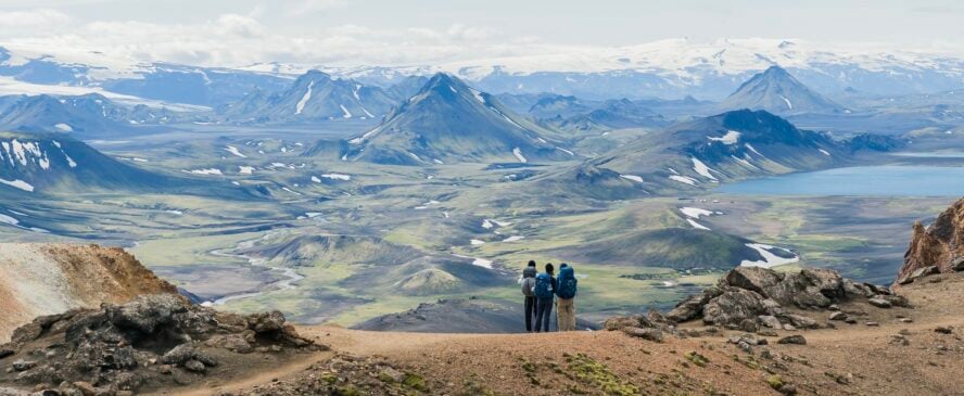
1. Laugavegur Trail, Iceland

The 55-kilometer (34 miles) Laugavegur Trail is a multi-day hiking route in Iceland that takes hikers through a series of otherworldly landscapes which feature volcanic mountains, lava fields, glaciers, geysers, black sand desert, lakes, geothermal pools and so much more.
The hike starts in the Landmannalaugar area, known for its colorful rhyolite mountains, and ends in the Thórsmörk Valley. Along the way, you’ll experience some of Iceland’s most iconic sights, including the Hrafntinnusker geothermal area, the Fjallabak Nature Reserve, and the Eyjafjallajökull glacier.
The trail is well-marked with cairns and signs, and there are mountain huts and campsites along the way where hikers can rest and spend the night. Just be aware that the weather in Iceland can be extremely unpredictable, sometimes going through all four seasons in a single day, so always be prepared for sudden changes.
The Laugavegur trek thrusts you into the mythical heart of Iceland, surrounded by contrasting scenery, colors, and landform. But luckily, you don’t need the strength and endurance of the Gods to enjoy it.


Laugavegur Trail, Iceland - Good to Know
Easy
4-6 days, depending on how much sightseeing you plan on doing.
Mostly undemanding, with the occasional steep hill or unbridged river crossing.
1,700 m (5578 ft)
Casual hikers looking for extraordinary views.
The Landmannalaugar area in the Fjallabak Nature Reserve in the Icelandic Highlands.
From late June through mid-September.
2. Kungsleden, Sweden

Kungsleden, meaning King’s Trail, is the longest and most popular hiking trail in Sweden. It stretches for 440 kilometers (273 miles) from the village of Abisko to the village of Hemavan in the Arctic wilderness. Along the way, the route passes through four national parks, vast expanses of wilderness (including Kebnekaise, the highest mountain in Sweden), and culminates in the northernmost province of Lapland.
The trail features remote and rugged terrain, with snowy mountains, dense birch forests, moorland, glaciers, lakes, and offers exhilarating views of Sweden’s wildest landscapes. Low altitudes and flat terrain coupled with well-maintained trails make Kungsleden suitable for all hikers, even kids. Every 10-20 kilometers you’ll find a mountain hut offering simple accommodation and respite for the night.
There’s plenty of flexibility here; the trail can be hiked both ways, all at once or in sections. If you’re looking for the classic approach, the northernmost section of the trek is the most popular, as it takes hikers through Abisko National Park—famous for its mountain scenery and the Aurora Sky Station, a prime location for viewing the Northern Lights.
Kungsleden, one of the world’s most beautiful hiking trails, passes through one of the least populated regions in Europe.
– 57hours


Kungsleden, Sweden - Good to Know
Easy to moderate
The full hike takes about a month to complete.
Mostly flat and undemanding, with a fairly gentle elevation profile.
Around 200 m (656 ft) per day on average.
Families and casual hikers.
Either of the two terminus villages—Abisko in the north or Hemavan in the south.
Mid-July to the end of August.
3. Blue Trail, Italy

Cinque Terre is a series of five colorful fishing villages perched on the cliffs above the Ligurian Sea in Italy. Most of the hikes here are relatively easy and can be done in a day, the Blue Trail (Sentiero Azzurro) being no exception. This 12-kilometer (7.5 miles) point-to-point path connects all five communities into possibly the brightest jewel of Mediterranean hiking.
The Blue Trail takes 2-4 hours to complete, but we encourage you to take your time and give ample attention to each village, paying visits to local shops and restaurants to sample the delicious seafood and wine the region is known for. There are also plenty of rest stops and scenic viewpoints along the way.
Because of the Mediterranean climate, the trail is open year-round, but some sections may be closed due to landslides or other natural hazards, so it’s important to check the conditions before starting your hike.
Cars have been banned within the villages for more than a decade, which means that the best way to travel along Cinque Terre’s hiking trails is on foot, just as famous poets have done over the centuries.
– Stefano Lera in Why The Hiking Trails of Cinque Terre Are Poetry in Motion


Blue Trail, Italy - Good to Know
Easy
2-4 hours
Mostly flat, with the occasional steep hill or set of stairs.
524 m (1720 ft)
Hikers looking for a soothing Mediterranean vibe.
The village of Monterosso.
Spring or fall, when the weather is mild and the crowds are smaller.
4. Alpe-Adria Trail, Austria-Slovenia-Italy

The Alpe-Adria-Trail is one of the latest additions to Europe’s constellation of long-distance treks. Passing through Austria, Slovenia and Italy, the route consists of 43 stages, each around 20 kilometers long (6-8 hours of walking time). Its name comes from the fact the trail starts on Grossglockner (the tallest mountain in Austria) and ends in the seaside town of Muggia in Northeast Italy.
Contrary to what its name might suggest, the trek features few Alpine stages, with most of them winding through open countryside, along pristine lakes and rivers, through verdant forests and picturesque towns. Similar to how geographical features transcend borders on a map, here languages, traditions, and cuisine spill over national lines and create unique blends of influences.
Along the way, you’ll visit the sites of famous WW1 battles, historic castles and medieval churches, go wine tasting in local vineyards, and sunbathe on the Adriatic coast. Completing the entire 750-kilometer (466 miles) trek would take a month and a half, so most hikers opt for completing a section or two at a time.
One of Europe’s newest long-distance hiking routes, the project was designed for pleasure and convenience from the get-go.
— Martina Kosmina in The Ultimate Pleasure Hiker’s Delight: Meet the Alpe Adria Trail


Alpe-Adria Trail, Austria-Slovenia-Italy - Good to Know
Easy to moderate
1.5 months for a thru-hike, 6-8 hours for each of the 43 individual sections.
Quite easy, without any significant technical portions.
Around 26,000 m (85,300 ft)
Casual hikers and families (especially for a day hike).
The trail starts at the foot of Mount Grossglockner in the Austrian region of Carinthia.
Anywhere between April and October. Peak season runs from July to August.
5. Alta Via 1, Italy

We can’t talk about the best hiking in Europe without mentioning Alta Via 1. This long-distance hiking trail is located in the Dolomites, also known as the “Pale Mountains”, which occupy an area of around 16,000 km2 (6,177 sq mi) in Northeast Italy. The trail is considered to be one of the most beautiful and challenging hikes in Europe, offering hikers panoramic views of the surrounding peaks and pristine alpine lakes.
Despite its difficulty, Alta Via I is still one the most approachable of all the high routes in the area. Starting from Lago di Braies in South Tyrol and ending in the province of Belluno, it covers a distance of approximately 120 kilometers (75 miles) and takes between 7 to 14 days to complete. Sections of the trail are punctuated by quaint rifugios or huts where local delicacies are served.
The trek will take you through some of the most dramatic landscapes in the Dolomites, including high-altitude meadows, deep valleys, and massive limestone formations. To complete it, you’ll need a good level of fitness and experience in mountain hiking, as there are some steep ascents and descents, as well as exposed sections that require careful attention. And if you want more of a challenge, go for the Alta Via 2 next!
When it comes to trekking in the Dolomites, the Alta Via 1 is number one (pun intended) for a multi-day hut-to-hut adventure.
— Augustina Lagos Marmol in The Best Hiking in the Dolomites: A Legacy of Limestone


Alta Via 1, Italy - Good to Know
Moderate
7-14 days
Steep and rocky, with some ladders and cables thrown in for good measure.
7,700 m (25,260 ft)
Backpackers looking for a real challenge.
The Alpine lake of Lago di Braies, one of the most photographed spots in Italy.
May or June, right before summer break hits its peak, or in the fall, when temperatures are lower.
6. Camino de Santiago, Spain

Camino de Santiago, also known as the Way of St. James, is a pilgrimage route that leads to the city of Santiago de Compostela in northwestern Spain, where the remains of the apostle St. James are believed to be buried. The route has been walked by pilgrims for over a thousand years, first by Christian pilgrims, then by the eager hikers of the modern world.
There are several ways to reach the terminus from various parts of Europe. The most popular route is Camino Francés, which starts in the French town of Saint-Jean-Pied-de-Port and covers a distance of approximately 800 kilometers (500 miles) over the course of several weeks.
The hike is both a cultural and historical experience, with diverse landscapes, medieval architecture, and charming communities strewn along the trail. Many hikers embark on the journey for spiritual reasons, while others do it for the physical challenge and sense of adventure.
The route is marked by yellow arrows and the famous scallop shells. You’ll never find yourself in the middle of nowhere as there are many albergues (hostels for pilgrims) where you can grab a bite and spend the night.
Are you ready to become a modern-day pilgrim? Embark on your Camino adventure and earn your compostela—certificate for accomplishment given to hikers who have walked at least 100 km (62 miles).
— 57hours


Camino de Santiago, Spain - Good to Know
Moderate
The Camino Francés route usually takes 30-35 days to complete.
Combination of woodland paths, hills, mountains, and paved roads.
Around 20,000 m (65,616 ft)
Experienced long-distance hikers with an interest in history, religion, or architecture.
There are various possible starting points in Spain, Portugal or France. Camino Francés begins in Saint-Jean-Pied-de-Port, a French village at the foot of the Pyrenees.
April through June; September-October.
7. Quiraing Walk, Scotland

The Isle of Skye feels like a portal to another dimension where giants roam the land and dinosaurs lay their bones in misty lochs. This majestic Scottish island is home to the looping 6.8-kilometer (4.2 miles) Quiraing Walk, one of the most dramatic day hikes in the world.
The trail begins at a nearby car park and follows a path up the hillside towards the Quiraing plateau. As you ascend, you’ll be rewarded with panoramic views of the Trotternish Ridge and the Inner Hebrides, an archipelago off the west coast of Scotland. Some of the most famous features of the Quiraing are the Needle—a tall, narrow pinnacle of rock that juts out from the plateau—and the Prison—a jagged tower of grass and rock dominating the skyline.
Also notable is the Table, a flat-topped rock formation that offers a great spot to rest and take in the view. Once you reach the top of the hill, you’ll find yourself on the Quiraing plateau, which is a unique landscape of rocky outcrops, deep gullies, and steep cliffs. The trail follows the edge of the plateau, offering sweeping views of the surrounding terrain.
Quiraing is a massive landslide with cliffs that slump down and create a really bizarre landscape of looming towers and pinnacles that guard hidden valleys.
– Gareth Williams in Why the Magical Isle of Skye Should Be Your Next Hiking Adventure


Quiraing Walk, Scotland - Good to Know
Moderate
2-4 hours
Undemanding, pleasant first half; the second half can get quite muddy.
392 m (1,286 ft)
Hikers looking for the most dramatic photo-ops
The trail begins at the car park on the east side of the road.
The best time to visit the Isle of Skye is spring, summer, and early fall.
8. Villingardalsfjall Peak Hike, Faroe Islands

The Villingardalsfjall Peak Hike is a popular hiking trail on the Faroe Islands known for its scenic beauty and challenging terrain. The hike starts at Viðareiði, the northernmost settlement in the Faroe Islands, where you’ll follow a path that winds up the side of the mountain. As you ascend, you’ll be treated to panoramic views of the vast landscape—deep fjords, smooth green-carpeted hillsides, and Viðareiði below.
The trail is quite steep in places, and you’ll need to scramble over rocks and boulders as you climb. Luckily, it’s also well-marked and maintained, so you shouldn’t have any trouble finding your way. As you near the top of the mountain, the markings will become less clear. Don’t follow the cairns to the left, but rather continue pushing up towards the summit.
At the top of Villingardalsfjall Peak, you’ll be rewarded with a 360-degree view few hiking trails can match. The Faroe Islands are like an enchanted fairytale land hidden from the rest of the world, and its unique setting makes it one of the best places to hike in Europe.
All the culture, history and traditions are connected to the island’s nature. No matter where you are in the archipelago, you can feel the force of the sea and smell the sea salt and grasses. It’s unlike anywhere else I’ve been.
– Albert Ojembarrena in Hiking in the Faroe Islands is Your Next Must-Do Adventure


Villingardalsfjall Peak Hike, Faroe Islands - Good to Know
Moderate
Around 4 hours
Steep rocky terrain all the way to the top.
890 m (2,920 ft)
Hikers (and photographers) looking for dramatic landscapes.
The Villingardalsfjall hike starts in Vidareidi village, the northernmost town in the Faroe Islands.
May to August, when the weather is at its most stable.
9. Samaria Gorge, Greece

Located on the Greek island of Crete, Samaria is the longest gorge in Europe, stretching for a whopping 16 kilometers (10 miles). As one of the biggest hiking attractions in a country filled with natural and historical wonders, it frequently sees hundreds, sometimes even thousands of visitors per day.
Hiking through the Samaria Gorge can be challenging, as it involves walking on rocky terrain and navigating steep descents and ascents. The trail gets quite narrow in some sections where the gorge cuts deep into Lefka Ori, the White Mountains of Crete.
This 5-7-hour hike begins at an altitude of 1,200 meters (3,937 feet) at the Omalos Plateau and descends towards the coast, where it ends at the village of Agia Roumeli. The whole way down, the trail is framed by rugged cliffs, pine forests, and the crystal-clear waters of the Samaria River. If you can handle the steepness, you’ll be rewarded with one of the best day hikes in Europe.
The Samaria Gorge is a veritable haven for biodiversity. Over 300 species and subspecies of plants and 900 animal species call it home.
— 57hours


Samaria Gorge, Greece - Good to Know
Moderate
5-7 hours
Downhill walk on rough terrain full of rocks, dirt, and several river crossings.
2,636 m (8,649 ft)
Competent hikers who enjoy biodiversity and can handle elevation change.
The Omalos Plateau, a tableland surrounded by the Lefka Ori mountain range.
You can only hike in the Samaria Gorge during late spring and summer.
10. GR 20

GR20, the twentieth “Grande Randonnée” or “great hike”, is a long-distance trail that crosses the French island of Corsica north to south. It’s considered by many to be the most challenging hike in Europe, with rugged terrain, steep ascents and descents, and narrow ridges which define the island’s jagged spine. Walking it is already challenging enough, but some hardcore athletes go as far as running it in hopes of breaking the speed record.
The trail covers approximately 180 kilometers (112 miles) and can take up to two weeks to complete. Divided into 16 stages, it takes hikers through some of the most beautiful landscapes in Corsica, including snow-capped peaks, rocky ridgelines, dense forests, and crystal-clear lakes.
To complete the thru-hike, you’ll need a very high level of fitness and experience with hiking on mountainous terrain, as there are some technical sections that require a good deal of scrambling. The trail is well marked with red-and-white stripes and there are refuges and campgrounds along the way where you can rest and spend the night.
Once you enter this alpine labyrinth, you’ll likely forget you’re on an island in the middle of the Mediterranean.
— Anthony Laplagne in GR20: Ultimate Guide for the Toughest Trail in Europe


GR 20 - Good to Know
Very strenuous
Around 2 weeks
Extremely rugged, full of steep ascents and descents.
10,500 m (34,500 ft)
This is a trek only for the fittest, most experienced and tenacious hikers.
Although it’s possible to do the trek in both directions, most hikers start in the village of Calenzana in the north.
from the end of June until the beginning of October.
11. Tour du Mont Blanc, France-Italy-Switzerland

The 170-kilometer (105 miles) Tour du Mont Blanc, one of the most celebrated (and trafficked) long-distance trails in the world, circumnavigates the Mont Blanc massif, passing through France, Italy, and Switzerland. Filled with iconic Alpine vistas and enough rustic charm to fill a dozen photo albums, it’s a staple of any self-respecting hiker’s bucket list.
Although there are many different starting points you can choose from, the trek traditionally begins and ends in Chamonix. Every day of the Tour is a new feast for the senses—from the cold granite spires of the Aiguilles to the sun-kissed slopes of Les Contamines; from the whistling of high winds above Mer de Glace, the largest glacier in France, to the jingle of cow bells in Val Ferret.
Throughout these 6-12 days, you’ll pass through picturesque villages and mountain huts, where you can rest and recharge with local delicacies belonging to three different cultures. The trail involves some steep ascents and descents, so you should have a reasonable level of fitness and endurance to complete it.
Each pass of the Tour du Mont Blanc is different. While the itinerary of the days might be similar—starting in a valley, heading over a pass and back down to a different valley—the views on the Tour du Mont Blanc never cease to amaze me.
— Natalie Mirzoeff in Tour du Mont Blanc Hike: Route, Preparation & Tips for 2023!


Tour du Mont Blanc, France-Italy-Switzerland - Good to Know
Strenuous
6-12 days
Very diverse—paved roads, flat dirt trails, steep rocky paths, narrow mountain passes, stream crossings…
around 10,600 m (35,000 ft)
Fit long-distance hikers looking to bag a classic trek.
There are many different options, but most people start in the Chamonix Valley, right under Mont Blanc.
The summer months, from late June to early September.
12. The Walker’s Haute Route, France-Switzerland

Stretching from the base of Mont Blanc in Chamonix, France, to the striking fin of Matterhorn in Zermatt, Switzerland, the Walker’s Haute Route combines rolling pastures and high mountain passes to form one of the best multi-day treks in the world. With only a fixed starting and ending point, it can take anywhere between 7 to 14 days to complete the trek.
The hike takes you through both serene and dramatic Alpine landscapes, stringing together massive glaciers, verdant meadows, and picturesque villages. Along the way, you’ll encounter challenging terrain, including steep ascents and descents, snowfields, and exposed ridges. The reward for this challenge is access to unparalleled views of some of the tallest mountains in the world.
Along with other determined hikers, cows, ibex, and chamois will keep you company throughout your trek. To successfully complete the Walker’s Haute Route, you’ll need plenty of energy, which is where the hotels and huts come in. Do yourself a favor and try the local delicacies—this is also a culinary journey!
Brace yourself for long daily hikes; patchworks of dramatic landscapes leading you from glaciated mountains reflecting in crystalline lakes to verdant valleys and meadows beneath 9,500-foot mountain passes.
— 57hours


The Walker’s Haute Route, France-Switzerland - Good to Know
Strenuous
1-2 weeks
Wide forest tracks, zig-zagging hillside paths and steep, rocky mountain paths.
Around 12,600 m (41,340 ft)
Tough trekkers looking for an alternative to the Tour du Mont Blanc.
Chamonix, France
Mid-July to mid-September, when the weather is mild and the snow has melted.
13. Trolltunga, Norway
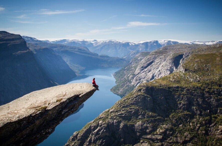
When it comes to trekking in Europe, the Trolltunga trail in Western Norway stands with the best of them. This scenic 28-kilometer (17.4 miles) out-and-back trail will take you through the Nordic wilderness and up to a majestic cliff jutting out 700 meters (2,300 feet) above Ringedalsvatnet Lake.
The trail can be challenging, especially during bad weather, as it involves some steep climbs and river crossings. However, most of the difficulty stems from the length of the trail. If you’re planning on doing it one day, make sure to start early. But if you’d like to immerse yourself in the untouched nature, consider camping under the northern sky.
The name Trolltunga translates to Troll’s tongue. Why, you ask? According to legend, there once was a troll who, thinking himself immortal, stuck out his tongue to mock the sun and was in turn petrified. As you journey through Norway’s vast landscapes shaped by ancient glaciers, you will be humbled just the same. Deep fjords, valleys, and waterfalls—this unique hike has them in spades.
The Trolltunga hike in Norway is one of those hikes where the end destination is phenomenal, but the journey itself is just as extraordinary and rewarding.
– Stian Ruud in Trolltunga Hike: Itinerary, Useful Info & Tips


Trolltunga, Norway - Good to Know
Strenuous
8–12 hours
The first section of the trail is a steep ascent on stone and gravel. After that it gets mellower, with smaller climbs here and there.
800 meters (2,625 feet)
Hikers with good endurance who aren’t terrified of heights.
The hike usually starts at the village of Skjeggedal in Vestland county. Alternatively, you can start at Mågelitopp.
Mid-June to mid-September, when the warm weather makes for ideal hiking conditions. Outside of this time window, you must go with a guide.
Good-to-know Info for Hiking in Europe
When traveling to a different continent for outdoor adventures, there’s a lot of different factors to consider: available budget, destinations, what your goal is, season and weather, accommodation… But as we all know, preparation is the key to success—so you want to do it well. To help you plan your trip to Europe, here’s some information you might find useful before booking your flight.
What’s the best season for hiking in Europe?
The answer to this question, of course, depends on where you’re going. There are beautiful hiking destinations around Europe available at any time of the year. Come springtime, the hidden trails of Tuscany are in full bloom. In summer, we love hiking the Via Dinarica, which runs from Slovenia to Albania. The mild temperatures of Portugal’s fall season are perfect for hiking the Rota Vicentina. And don’t get us started on winter hiking in Iceland under the northern lights!
As you can see, there’s no shortage of options. As a rule of thumb, however, try to aim for summer if you’re going to hike in Northern Europe or in the Alps. In Mediterranean countries, where summers get prohibitively hot, spring and fall are your best bet. Winter months are great for scenic lakeside hikes, snowshoeing tours in the mountains, and trips to sunny islands such as Malta, Madeira, or the Canaries for rejuvenating walks without crowds or scorching heat.
What’s the best country for hiking in Europe?
It’s impossible to pick the best country for hiking in Europe. However, strong cases could be made for Italy, France, and Iceland, which all appear on our list and include many other world-class trails that deserve honorable mentions. Too many to count!
What are some cheap hiking destinations in Europe?
If you’re hiking in Europe on a budget but still want to experience a first-class adventure, some destinations you should definitely check out are Georgia’s Caucasus mountains, the Tatra Mountains between Slovakia and Poland, or the Julian Alps in Slovenia—recently we fell in love with hiking the Juliana Trail. Whichever one you choose, you can’t go wrong!
The Best Hikes in Europe At Your Fingertips
There we go, the hardest part of the job is done. The list of the best hikes in Europe is finally in your hands—now it’s your turn to go out and enjoy what many consider to be hikes of a lifetime. Start with our suggestions and curate your own best-of list. We can’t wait to hear what you come up with.
Psssst, by the way… If you happen to see someone wearing a red hoodie with “57hours” emblazoned on their back out there in the great outdoors, don’t be shy, give us a holler! You never know, we might just let you in on what’s the next big thing in the hiking world.