Ah, Arizona—the Grand Canyon State! Home to captivating desert vistas and… even more desert? Given Arizona’s dry climate, most people envision a gorge here, a rock there, a cactus or two, and nothing in between. But, as is the case with the best Joshua Tree hikes, that’s a common misconception.
Coming from a lush place like Colorado, I was skeptical at first too. When I encountered the forested mountains and glittering lakes that decorate Arizona—if you know where to look—all my worries melted away (in that hot, hot sun, of course).
Crossing the border between the state’s two tectonic provinces, I came to appreciate the nuances of its ever-changing terrain. To my surprise, more than half of Arizona consists of mountains and plateaus! For a hiker like me, that’s great news, especially when most of it is 4,000 feet above sea level. To top it off, the dramatic landscapes culminate in the Grand Canyon—one of the most spectacular sights on Earth.
Sure, unlike the ever-popular hiking in San Diego, the hikes in Arizona may be an acquired taste, but its beauty is plain to see. For me, there’s nothing like it.

Pros and Cons
With the third highest level of biodiversity in the U.S., six national forests (one of which holds the world’s largest stand of ponderosa trees), and a climate that allows expansive desert too, this land is an interplay of contrasts to rival the backpacking in Big Sur.
Nowhere is this more evident than on the longest and hardest hike in the state: the Arizona Trail. An 800-mile thru-hike, it stretches from Mexico to Utah, crossing grasslands, isolated mountain ranges, forested plateaus, and the Great Canyon.
Luckily, you don’t need to take two-months off to see all that’s on offer—there’s plenty of day hikes in Arizona too. Without further adieu, consider this your A-to-Z guide to the best trails in AZ.
1. Grand Canyon: The Grand-Daddy of the American Outdoors
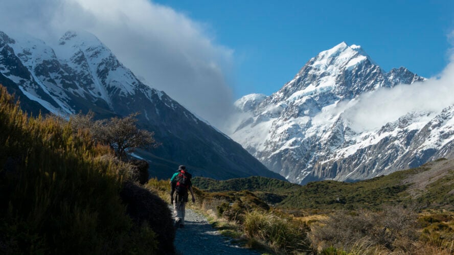
If you’re in Arizona, you owe it to yourself to go hiking in Grand Canyon National Park. This enormous gorge was formed a whopping six million years ago by the Colorado River cutting into its namesake plateau. (Fun fact: six million is also the number of visitors it receives every year.) It’s home to colorful flora, abundant wildlife, and exposed rock layers charting the history of the Earth.
There’s not much to say about the Big Ditch that hasn’t been mentioned six million times—except that no other national park compares. For example, the hiking in Yellowstone is iconic in its own right, but I consider vast areas like that more as drive-throughs, one-and-done trips you can experience from the comfort of your car.
The hiking tours in the Grand Canyon, however, are a walk-and-gawk type of deal. You can’t just peer out over the edge, take a photo, then drive off into the sunset feeling satisfied. To take in the magnitude of this geological marvel, you have to go down and immerse yourself.

Into the belly of the beast… And out again
For first-time visitors, choosing from the area’s huge number of hiking trails can feel like a daunting task. To help you get started, here’s a list of the five best hikes in the Grand Canyon.
However, if you’re looking for the full Grand Canyon experience, the rim-to-rim tour is the only answer. Traditionally, it’s a four-day backpacking trip taken from the North Rim to the South Rim. The challenges along this 24-mile trail include oppressive heat, treacherous terrain, and sharp elevation changes.

Over the first two days you’ll descend 6,000 feet into the canyon, stopping at Cottonwood Campground and Phantom Ranch along the way. The next two days feature similar elevation gain over the course of fewer miles, which feels like climbing up a never-ending staircase.
When you get to the end, standing along the top of the South Rim, seeing the canyon’s prominent rock layers enveloped in an enchanting purple haze is the kind of image that stays with you for the rest of your life. Then, you will know why many consider Grand Canyon one of the best hiking destinations in the US.
2. Phoenix Has a Burning Passion for Hiking
Arizona’s scorching and sprawling capital is located in one of the world’s sunniest regions. Phoenix’s long, hot summers and short, mild winters make it a popular year-round destination for outdoor enthusiasts, but what really won me over is the proximity to… well, pretty much everything, including some of the best hikes in Arizona located within city limits.
One of the classic Phoenix spots is Camelback Mountain, named after its two peaks resembling a head and a hump. Once a sacred site of the ancient Hohokam culture, the tallest peak in the area is now a popular destination for hikers and rock climbers.
There are two main trails leading to the summit—the Cholla Trail and the Echo Canyon Trail, each about a 2-3-hour round trip. The Cholla Trail on the east side of Camelback is a longer, more gradual climb, while the Echo Canyon Trail is a steep, expert-level hike. Characterized by a lot of scrambling, this route often surprises tourists looking for a quick climb to the top.
Many warning signs exist along the two trails, and they’re there for good reason. In summer, temperatures soar into the triple digits, and unprepared hikers lose their lives to heat exposure every year.

The Superstition Mountains—tall tales you have to see to believe
A volcanic range located 50 miles east of Phoenix, the Superstition Mountains are my favorite spot in this part of the state. Although only 6,000 feet above sea level, its jagged peaks jut out of flat desert, making them appear colossal.
The range is part of the Superstition Wilderness Area, which spans over 160,000 acres. Cacti, wildflowers, and occasional trees freckle the arid landscape. Native to the Sonoran desert, the rare saguaro cactus grows at lower elevations in this region—an iconic symbol of the state.
These menacing peaks have been the subject of many legends dating back to the 19th century. The Pima natives used to speak of unexplained disappearances and mysterious deaths that occurred here. The most famous tale, however, is that of the Lost Dutchman’s Gold Mine. Although it’s never been found, it’s believed to be hidden in a secret cave somewhere in the mountains. While the Superstitions remain a treasure unto themselves, the thought of a legendary gold mine adds a degree of intrigue.

Scrambling along the Supes
It’s hard to go wrong when choosing a hike through the ‘Supes’. While most of the trails are lengthy and moderately difficult, starting on the north side of the mountain, the Hieroglyphic Canyon Trail is one notable exception. This family-friendly option starts in the south and winds through a bouldery canyon filled with pools of water.
At the end of the trek, you’ll find 1,500-year-old petroglyphs believed to be created by the Hohokam people. Although there’s a difference between hieroglyphs and petroglyphs, the rock carvings gave the trail its name.
One of my favorites hikes in Arizona is the moderately-rated Fremont Saddle via the Peralta Trail. This trail winds up switchbacks through a gorgeous canyon before reaching the eponymous saddle. Here, you’re treated to an arresting view of Weavers Needle, a 1,000-foot volcanic monolith that pierces the sky.
There isn’t enough space to mention all the great hiking in the area, but I’d be remiss to leave out the gripping scramble-fest, Siphon Draw Trail. This 6-mile round trip leads to the top of the Flatiron and takes an average of four hours. Considered the hardest hike in the Superstitions, it’s unclear whether reaching the summit is coveted more for the bragging rights or the views.

3. Contrary to Tracy Byrd, It’s Never Too Soon for Hiking in Tucson
If you’re not in the mood for the Phoenix crowds, then you might want to check out Tucson for some of the more relaxing hikes in Arizona.
The two cities share the same hot climate, but unlike Phoenix’s urban trails, Tucson offers true wilderness escapes. It’s surrounded by five mountain ranges and home to Saguaro National Park, which holds 165 miles of hiking trails. In the span of 45 minutes, you can go from a desert ecosystem filled with cactus and shrubs to full-blown forests of aspens.
Whether Phoenix or Tucson is a better hiking destination is an ongoing local debate. Between the former’s diversity of trails and the latter’s landscapes, it’s hard to say. I prefer both, to put it diplomatically.

The forks, forests and falls of Tucson’s hiking zones
Thanks to its easy mountain access, Tucson is blessed with some of the best day hikes in Arizona. A popular local spot is Sabino Canyon in the Colorado National Forest, home to 14 scenic trails with options for families and hardcore hikers alike—with my suggestion for must-do hikes being Bear Canyon and Blackett’s Ridge.
The Pusch Ridge Wilderness Area in Santa Catalina’s Coronado National Forest is another notable spot. It has some of my favorite trails in Tucson, including the Pima Canyon Trail. This is a moderate 10-mile out-and-back trek with some rocky sections, as well as beautiful views of the city and distant mountains.
For something more strenuous, check out the Ventana Canyon Trail to Window Peak. This (very) rocky hike passes the Maiden Pools en route to the massive rock formations above. If you manage to make it up there, you’ll see a fascinating round opening in the looming structure atop the Santa Catalina Mountains.
Finally, why not check out Saguaro National Park while you’re here? The well-maintained Bridal Wreath Falls Trail is a lovely hike punctuated with moderately graded climbs to the base of—you guessed it—Bridal Wreath Falls. This is a great place to cool off and snag a couple of photos before heading back down.
4. Sedona’s Red Rock Country Holds My Favorite Hikes in Arizona
In the heart of the Coconino National Forest, 100 miles south of the Grand Canyon, lies Sedona. This red rock oasis is famous for its spectacular sandstone formations and vortex sites—and for my money, where you can find the best hiking trails in Arizona.
When a community of 10,000 people receives over 3 million visitors per year, you know it must be special. As the sunlight hits the mountains, buttes and mesas, the smooth sandstone emits a glow unlike anywhere else on earth, especially in contrast to the juniper and sagebrush that line the trails. When I stand on top of Airport Mesa and look down on Sedona—over that landscape painted in swathes of bright red and green—it feels like Christmas in the desert.

The finest sunset views in the country
I love taking my guests to see Cathedral Rock, an imposing sandstone butte in southern Sedona. Most people take a short scenic tour of the front side, but I prefer a secret trail that goes behind the rock towards Oak Creek.
There’s some scrambling involved to the spectacular 360-degree view at the top, where you can see the Chapel of the Holy Cross, a fascinating piece of architecture and hands down the most beautiful church in Arizona.
The 11-mile round trip on the Wilson Mountain Trail is a good option for more experienced hikers. The trail begins steadily before rising through a dense oak grove, ultimately giving way to a forested plateau. This is where you’ll catch your breath before that final push to the Sedona Overlook.
Take a hidden trail to Sedona’s secret cave
For a more relaxing outing, consider the 7-mile out-and-back Boynton Canyon Trail. It’s mostly flat terrain capped with a short climb leading to a scenic viewpoint. This is a popular trail in part because dogs are allowed (on a leash) and there’s plenty of shade.
The other reason for the traffic is the unmarked side route that veers off the official trail towards the coveted Subway Cave. What was once a well-kept local legend is now the target of eager hikers from all over the world—and one of the most photographed spots in Sedona.

5. The River-Made Miracles of the North
Canyon hikes in Arizona: Stotting and slotting through Antelope
If you’ve ever stumbled upon photos of hip people walking through psychedelic corridors of wavy orange sandstone, chances are they were taken at Antelope Canyon. Located in the vast Navajo Nation on the border of Utah, this stunning slot canyon is separated into five scenic areas—and is one of the most popular destinations for hiking in northern Arizona.
An interesting thing about hiking tours in Antelope Canyon is that it’s mandatory to have a Navajo guide. This part of Arizona is prone to flash floods, which are especially dangerous in the long, narrow slot canyons. For safety reasons, having an experienced local guide by your side is a must.
Upper Antelope Canyon (also known as The Crack) is famous for the beautiful display of light rays dancing on the canyon walls. The only downside is the unavoidable crowds.
Lower Antelope Canyon and Rattlesnake Canyon aren’t blessed with pretty lights, but they make up for it with even more undulating rock formations and trippy colors. If you’re looking for something more adventurous, don’t miss the long and rugged Mountain Sheep Canyon.

Basking in the glory of the Colorado River
Located near Page and Antelope Canyon, a certain curvy meander of the Colorado River draws two million tourists every year. I’m talking, of course, about Horseshoe Bend. To get there is less of a hike and more of a 1.5-mile walk from the parking lot. But what a sight—I’ll never get tired of sitting on the edge of that cliff and watching the sun sinking into the horizon.
I usually end my hiking tours by checking out Lake Powell and the 710-foot Glen Canyon Dam, one of the largest man-made reservoirs in the country.
There are different ways to continue your adventure from there. You can take a canoe trip to Lees Ferry, a small settlement that marks the official start of the Grand Canyon, while whitewater rafting and fly fishing are also popular. You might even catch a glimpse of high-spirited adventurers finishing their multi-day trips through the Paria Canyon Wilderness, which holds some of the best backpacking trails in Arizona.

Good-to-know Info for Hikes in Arizona
When is the best time to visit Arizona?
The best time to visit Arizona is spring or fall. The Grand Canyon State is notorious for its blistering summers, which have more than 50 dangerous heat days per year—defined as a heat index above 105 F—the second highest total in the country. In the spring and fall, temperatures are cool in the mountains and reasonably warm in the desert, making for a pleasant hiking experience.
What clothes to wear for hiking in Arizona?
The two main things you have to worry about are heat and sunburn. When hiking in the desert, you need long-sleeved shirts and pants to shield your skin from the sun. Your clothing should be lightweight, light-colored, breathable, and loose-fitting in order to prevent dehydration.
Can you hike in the summer in Arizona?
There’s plenty of locations where you can enjoy summer hiking in Arizona. Early morning hikes in the Phoenix area can be completed before the heat picks up, for example. The best place for day trips are the mountains around Tucson and especially the Flagstaff area, where the high elevation and cooler temperatures will keep you more protected from dehydration and heat stroke.

The Sizzling Hikes in Arizona Will Leave You Hot and Bothered
There’s a lot to appreciate about Arizona’s sublime scenery. When I first got here, the rock formations that decorate this vast desert caused me to fall in love with the terrain.
Now, as a guide, I can show my favorite places to other people and share in that same glee. It’s a feeling that never, ever gets old. Even as I’m writing this, my feet are itching to get back out there. So, what are you waiting for? Get your boots on, grab some sunscreen, and I’ll meet you out on the trails!