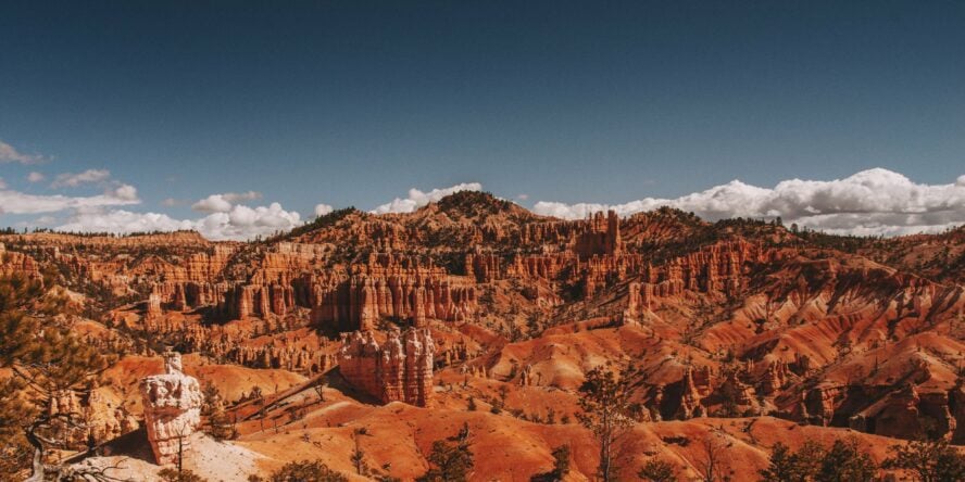
Like Senators in an ancient Greek amphitheater, the hoodoos huddle as if conferring important matters of the third kind.
These whimsically arranged spires are the star of the show, but they aren’t the only thing that make the hikes in Bryce Canyon so unique.
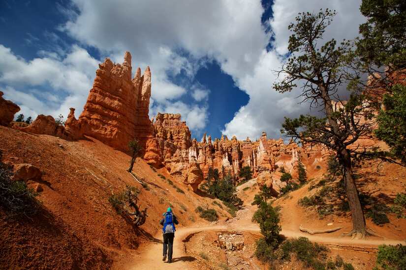
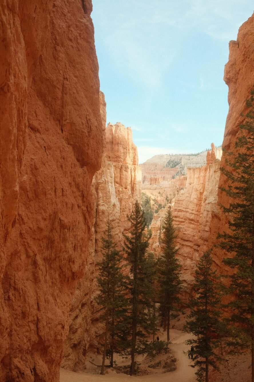
When I first came to the park I was shocked—not by the hoodoos, mind you—but by the descent! From the entrance, hikers retreat from the rim, hovering around 9,000 feet above sea level, into a maze of thin slots, cavities, portals, fins, and bizarre towers. These features provide an endless array of seemingly subterranean landscapes to explore.
While neighboring Zion National Park might get all the limelight (and the crowds), Bryce Canyon stays just enough under the radar. That’s why I consider this horseshoe-shaped venue of weathered mudstone a must visit destination for a day trip or backpacking adventure.
I Learned a Long Time Ago: Hiking Is the Best Way to Explore an Area
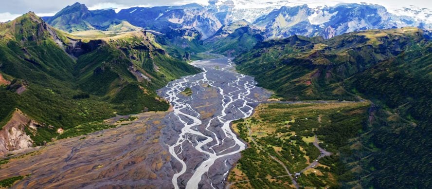
Growing up in St. George, Utah, being in the outdoors literally came with the territory. From Zion National Park, an hour from home, to the towering crack climbing in Indian Creek, and the remote backpacking of Paria Canyon, I have made every effort to see it all.
From an early age, I’ve been hooked on sharing my passion for our national parks with others. I personally think there’s no better way to enjoy your environment than by hiking through it, so I joined Zion Guide Hub as a way to not only improve my guiding skills but welcome more people to the beauty of the area.
Since then, I’ve done tons of hikes in Southern Utah, but without a doubt, my favorite place to hike is Bryce Canyon National Park.
Bryce Canyon’s Hikes are Unlike Any Other
Apart from the hiking in San Diego, nothing can match the accessibility of Bryce Canyon’s hikes. The park’s relatively small size—56 square miles containing just 11 trails—gives the area an approachable, choose-your-own-adventure feel. Four of the trails are rated as easy, four are moderate, while three are considered strenuous, and they can be effortlessly connected to create your own journey. There are plenty of permutations to keep you coming back too.
It’s important to note that there is no large tourist town nearby, or the amenities that come with it. Bryce Canyon City (shown on some maps as just “Bryce”), has a modest population of 228; about the capacity of a typical movie theater. That means lodging and food are scarce, but it also keeps the area relatively quiet.
Compared to Zion National Park—which was the third most visited national park in 2020 with over 4.2 million visitors—Bryce Canyon had just 1.4 million guests. What I’m getting at is this hoodoo haven offers all of the spectacular views that Zion has, but with a fraction of the crowd. You’ll see what I mean on some of my favorite hikes.
The Best Hiking Trails in Bryce Canyon National Park
If you’re looking for what hike to do in Bryce Canyon, my best answer would be: all of them! However, we have to be realistic, which is why I’ve narrowed it down to my six favorite trails.
Easy Hikes in Bryce Canyon:
-
- Sunset Point to Sunrise Point – 1.1 miles out-and-back, best for small children
- Bristlecone Loop – 1 mile loop, best for wildlife watching
- Mossy Cave Trail – 0.8 mile out-and-back, best for families
Moderate-To-Strenuous Hikes in Bryce Canyon:
-
- Queen’s Garden Trail and Navajo Loop – 2.9 mile loop, best for seeing it all
- Fairyland Loop – 8 mile loop, best for a longer hike
- Rim Trail – 11 miles out-and-back, best views in the park
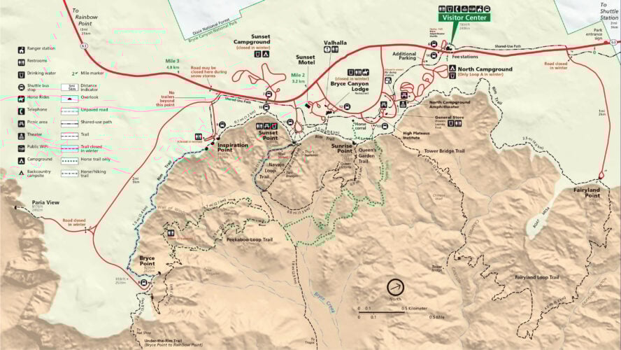
Map of Bryce Canyon’s hikes
1. Sunset Point to Sunrise Point Trail

This has got to be one of the best hikes in Bryce Canyon because it gives you an aerial view of the sprawling hoodoos below, with an easy approach. The trademark of the trail is the park’s heroic hoodoo, Thor’s Hammer, a fiery heavy-headed mace that brushes the sky above.
An easy hike in Bryce Canyon, it’s a one-mile, out-and-back that is suitable for all skill levels. In particular, it’s gentle on the knees because it is one of the only flat paths in the park (most other trails descend into the canyon, which then requires some climbing to get back out). As part of the paved portion of the Rim Trail, this area is wheelchair accessible and allows leashed dogs.
Fair warning: because of the accessibility, this is one of Bryce Canyon’s busiest trails.
Sunset Point to Sunrise Point Trail - Good to Know
1.1-mile (1.8 km) out-and-back
Negligible
Easy
20-30 minutes
From the Visitor Center, head south down Bryce Canyon Scenic Drive, take a left onto Sunset Point Road, and park at the Sunset Point parking lot, where you’ll find the trailhead.
During winter, you’re likely to encounter black ice on the trail. Make sure to bring grippy hiking boots, and even microspikes.
2. Queen’s Garden Trail and Navajo Loop

If you only have one day to hike in Bryce Canyon, the Queen’s Garden-Navajo Loop is my suggestion. It’s the biggest bang for your buck in terms of seeing much of the park in a short amount of time.
Passing through you see layers of limestone, like rings on a tree trunk, that mark geological time. Iron oxide expresses in the warm reds, oranges, and yellows on the lower portions with the occasional dash of pink or purple from manganese oxide. The upper regions fade from orange to white where the limestone doesn’t contain minerals.
The beauty of this moderately strenuous, 2.9-mile hike is you start above the hoodoos and descend through them as if you are walking through a forest of trees; except it’s rock. At the end of the Queen’s Garden portion, you’ll find a feature that resembles Queen Victoria, before ascending back out of the canyon via the Navajo Loop Trail.
Queen’s Garden Trail and Navajo Loop - Good to Know
2.9-mile (4.6 km) loop
600 ft (183 m)
Moderate
2-3 hours
Clockwise: Start at the Sunrise Point parking lot, and walk east toward the rim. Near the Rim Trail, turn right and follow the path until the junction with Queen’s Garden trail.
Counter-clockwise: From Sunset Point, descend a paved path with safety railings. After about 100 feet, turn left at the junction to access the eastern leg of the Navajo Loop.
Doing the loop clockwise is recommended, as the views of the Bryce Amphitheater are more prominent that way. Plus, Queens Garden is less steep than Navajo Loop, making the descents safer.
3. Fairyland Loop

Fairyland is one of the top hikes in Bryce Canyon if you’re looking for solitude. This eight-mile loop is one of the park’s more strenuous hikes outside of the main artery, and it feels about as remote as hiking in the Canadian Rockies. It descends nearly 1,800 vertical feet, so be prepared to make up the difference on the way back!
Relative to more difficult hikes, like Zion’s infamous Angel’s Landing—which are not only steep but incredibly narrow and uneven—all of the grades in Bryce Canyon are easy to moderate. Rather than proffering a physical challenge, Fairyland teases up a magical world of geological nuances, from the Bristlecone pines at the rim down to the harrowing hoodoos and past the ever so slowly eroding thin rock walls known as fins.
From the bottom of Fairyland follow a short spur trail to gaze at the Tower Bridge—a double-arched feature with a tall spire on the right side. Unlike many of the other hikes here, there’s a good chance that you won’t stumble upon a single person, as if you were hiking in Alaska.
Insider tip: be sure to do this hike early in the morning or pack plenty of sunscreen, as there is very little shade cover!
Fairyland Loop - Good to Know
8 miles (13.4 km)
1,800 ft (550 m)
Moderate to challenging
3-5+ hours, depending on your fitness level
The hike starts at Fairyland Point, just south of the park entrance.
Bring plenty of water, snacks, and electrolytes. Also, keep an eye out for snakes on the trail, especially in the sunny months.
4. Bristlecone Loop

If you drive on the rim all the way to the south end of Bryce, you’ll come up to the highest elevation point in the entire park. A short, one-mile loop trail leads to 1,800-year-old bristlecone pines and vistas that expand as far as the eye can see.
Swing your head around and look out clear over the Grand Staircase-Escalante in the east, peer towards Zion in the southwest, and gaze at the mountains north of Bryce, including Boulder Mountain and Mount Ellen, for a 360-degree view of the state!
Lush with Blue Spruce, Douglas Fir, and White Fir, this area of the park is a preferred habitat for a variety of wildlife including grouse, woodpeckers, owls, and a variety of small mammals. Remember, never feed any wildlife and do not approach them!
A note about access: this trail is a top choice for family hikes in Bryce Canyon, as it’s suitable for most anyone, including young kids and the elderly. However, it’s not paved like the Sunset-Sunrise portion of the Rim Trail, so it is not wheelchair accessible nor does it allow dogs.
Bristlecone Loop - Good to Know
1 mile (1.6 km)
89 ft (27 m)
Easy
25-30 min
From the Visitor Center, drive 16 miles south to the Rainbow Point parking lot. At the southeast side of the lot, you’ll find the Bristlecone Loop trailhead.
Feeding the wildlife is strictly forbidden. Make sure not to harm the fragile ecosystems thriving along the trail
5. Mossy Cave Trail

You weren’t expecting a waterfall hike here, were you? Fun fact: the Mossy Cave Trail is one of the lowest-elevation hikes in Bryce Canyon, and one of the only ones that start with a climb and end with a descent. It’s a straightforward, fairly easy trek that’s doable with young kids.
The meat of the trail meanders below some hoodoos in desert landscapes similar to what you get on Joshua Tree hikes. In all honesty, isn’t much to talk about. However, the finale is where it gets cool: reach the end of the path, and you’ll find the titular mossy cave (which is more of an overhang) and a small, scenic waterfall.
Artificially created by the pioneers as an irrigation source, the waterfall is now a sensation in the warmer months. When it gets hot, many hikers choose to stand or sit under it, seeking refuge from the summer heat. It does an admirable job, and the kids love it.
Be warned: the Mossy Cave area is very popular, so the parking lot gets busy during the day. I recommend planning your visit for the early morning or, since the hike takes less than an hour, late afternoon. Also, there’s no potable drinking water along the trail and no trash receptacles, so pack your waste out.
Mossy Cave Trail - Good to Know
0.8 miles (1.3 km) out-and-back
300 ft (91 m)
Easy
Less than 1 hour
From the Visitor Center, follow the UT63 north for 4 miles to the junction with SR 12, then turn right and drive another 3.5 miles. The parking for the trek will be on the right-hand side.
The parking lot and the waterfall are busy during the day, so plan your hike for early in the morning or late in the afternoon.
6. Rim Trail

With panoramas to rival the best hikes in Arizona, the Rim Trail follows the edge of the Bryce Canyon amphitheater, encompassing Fairyland, Sunrise, Sunset, Inspiration, and Bryce Point. The elevation changes may be steep and some of the switchbacks are strenuous, but the views more than make up for the effort.
Starting at Fairyland Point, you’ll follow the rim in the shape of a deranged crescent from up north at Fairyland Point, passing by the Bryce Canyon Lodge, and reaching the end at Bryce Point. Seeing the park’s finest landmarks from diametrically different perspectives evokes the coolest parts of Grand Canyon hiking.
This is one of the most fun and flexible hikes in the park. Most of the trails in Bryce Canyon start at the viewpoints and parking lots near the rim, which means it’s easy to mix and match other trails with this one. You could spend the whole day just doing detours.
The section of the trail between Sunrise and Sunset Point is paved and wheelchair accessible. It’s also the only part of the hike that allows dogs. If you’re looking to sample the Rim but you can’t commit to a full thru-hike, it’s the way to go.
Rim Trail - Good to Know
11 miles (18.5 km) roundtrip
200 ft (60m) overall, but with several steep uphills and downhills
Moderate to challenging
4.5-5 hours
The hike starts at Fairyland Point, just south of the park entrance.
You can theoretically start and end this loop at either Fairyland, Sunrise, Sunset, or Inspiration Point, and many people choose to add some of the nearby loop trails to the hike.
A Few Tips to Enjoy Your Bryce Canyon Hiking Trip
What is the best time to visit Bryce Canyon National Park?
Depending on your preferred weather, you can hike Bryce Canyon National Park any time of the year. Summer, May through September, is the busiest and hottest, with highs in the 80s. Winter comes to Bryce early, usually snowing in October.
Snowshoeing and cross-country skiing are allowed in the park, and the stark contrast of brilliant red sandstone adorned with a crisp white coat fills me with a bit of holiday joy. Spring often feels like winter, with snow storms hitting as late as April.
When should I visit Bryce Canyon National Park for hiking?
For me, the best time to visit Bryce Canyon for hiking is probably the fall, winter, or spring — i.e. any time that isn’t summer. This is because I prefer to avoid the crowds and the summer heat makes many of the more exposed trails along the rim much less enjoyable. However, your choice of season matters much less here than in most other parks. Come whenever, and you’ll have a good time.

What are the best places to sleep near Bryce Canyon National Park? Can you backcountry camp there?
Looking for the best lodging in Bryce Canyon? Don’t expect too many options — there is Bryce Canyon Lodge within the park and then there’s only one hotel in Bryce Canyon City, Ruby’s Inn.
The Inn has 368 guest rooms and free buffet breakfast for guests, and for those who want to “rough it” there are RV hookups and campsites too. The best full-on camping near Bryce Canyon National Park is close to the Visitor Center: the North campground is first-come-first-served while the Sunset campground takes reservations. Camping outside of the designated campsites is not allowed.
What are the best places to fuel up on some delicious food and drinks?
There isn’t a large tourist town outside of the park, which means there aren’t a lot of amenities. However, for restaurants close to Bryce Canyon, Ruby’s Inn features three dining establishments: Cowboy’s Buffet & Steak Room, Canyon Diner, and Ebenezer’s Barn and Grill.
There is also Bryce Canyon Coffee Company for a hot cup of joe and a pastry, and Stone Hearth Grille for a bit of a swankier meal. The Bryce Canyon General Store has all the camping food basics if you’re just looking for one last ingredient to complete your stovetop meal.
Where can I get some hiking essentials?
This is not the place to forget your hiking boots. Since you’re about two hours from a major gear shop, Ruby’s Inn is really your only option. Their General Store carries everything from produce and snacks to hats, toiletries, and hiking supplies.
Parking and passes in Bryce Canyon National Park
There are designated parking lots inside Bryce Canyon park. If you do not park in a designated spot you will be subject to a ticket and potential tow. Bryce Canyon is a national park, which means there’s an entrance fee to enter, no matter the time of year, or you can purchase an annual park pass.
Do I need a permit for hiking and camping in Bryce Canyon National Park?
Permits are required for overnight visits to the park. Beginning December 2022, overnight visitors to Bryce Canyon can reserve permits for peak-season trips (March through November) up to three months in advance via the Recreation.gov website, as well as on a walk-in basis in the visitor center. Permits for winter trips will remain on a walk-in basis only.
A permit will set you back $10, plus $5 per person listed on the permit, and overnight stays are limited to a maximum of 14 nights. Keep in mind that, even if you book your permit online, you’ll still have to check in at the visitor center so you can review backcountry regulations and rent a bear canister or get the one you brought inspected.
Bryce Canyon Is a Welcome Escape From the Ordinary
Immersing yourself in the peculiar pigmented landscape and walking among the ancient giants etched from water and wind is an experience unlike any other. No matter how many times I visit, I never get tired of hiking the trails of Bryce Canyon. It’s a great way to get away.