The giant fish raged against the might of a demi-god. Māui tightened his grip on the braided flax cord and pulled, sweat flinging from his brow and back into the cosmic ocean. The canoe teetered and splashed but didn’t tip, anchored as it was to a large stone at its stern.
Waves crested and crashed from the rising sea as Te Ika a Māui was hauled from the water by a fishhook lodged in its lip: a land-sized fish.
Māui the trickster, the clever one, had done it again—he’d raised an island.
According to Māori mythology, the vestiges of the beast make up the mountainous terrain of the North Island that we know today. The South Island is the canoe from where Māui and his brothers fished, with its anchor at Stewart Island.
That’s the backdrop: wherever you go hiking in New Zealand you will find folklore deep-rooted in tribal culture coupled with unspoiled and unpopulated landscapes.
It is a world where existential stories are for the heart and wilderness for the soul.
In the Corner of the Globe Rises a World Treasure
From a U.S. or European perspective, New Zealand is an island that occupies a far flung part of the map, and imagination.
Located 2,000km (1,200 mi) east of Australia in the southwestern Pacific Ocean, the country is divided between the North and South Islands, plus 700 tiny islands (for a total landmass larger than Great Britain). Formed by lunar-like landscapes, active volcanoes, and undulating lanes of tundra and tropical forests, every twist and turn is a bewitching plot fit for myth, or the movies.
All about Aotearoa
New Zealand, or Aotearoa in Te Reo Māori (the Māori language), is considered one of the last places humans set their eye on. Polynesian navigators began migrating to the “land of the long white clouds” between 1250 and 1300 and they came upon a region that had flourished in solitude—with 80 million years of geographic isolation there are animals and plants that you won’t find anywhere else on the planet.
In some sense, the islands are like a breathing reservoir of biodiversity: one-third of the country is under national parks in order to sustain the unique biomes.
In the Land of the Lord of the Rings
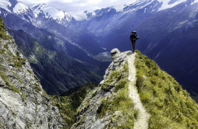
Today, these conserved realms are open to travelers, many who come to see the exemplary Lord of the Rings backdrops made famous when the trilogy came out in the early 2000s. Luckily, the infrastructure is well designed: there is an extensive network of tracks, swing bridges and public backcountry huts, which makes hiking the best way to see New Zealand’s nature, and the country one of the best hiking destinations in the world.
The Great Walks: The Best Hikes in New Zealand
2022 is the celebration of three decades of the Great Walks initiative. The Department of Conservation (DOC) has formulated an array of tramping trails through the country—and what is special about each one is that they are rooted in the heritage and distinctiveness of place, from the coastline to rain forests to its alpine terrain.
Most of these hiking trails in the North island of New Zealand range from 32 to 82km (20 to 51 mi) and usually take 3-6 days to complete. Along the way you’ll engage with a rich tapestry of Māori culture and landscape—the long and skinny islands are transected by steep mountains and sit between seas which make it wild, windy and wet at times.
Discover the best of New Zealand by hiking the North Island
I consider myself lucky to be born in Tamaki Makaurau (Auckland) because the city is the gateway into the rest of the country, from both a logistical and cultural sense (it has the largest Polynesian population in the world, for example). After spending my childhood discovering the volcanoes and coastlines of the area, I knew that I was meant for the backcountry life.
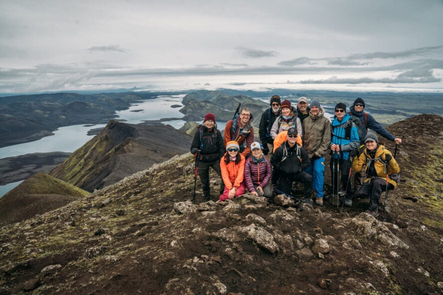
From there, I spent 15 years teaching outdoor education in New Zealand, Australia, Scotland, and the U.S. In 2018, I returned to guide with Hiking New Zealand, in order to help introduce more people to our outdoors and culture, both the South and the North Island. The Great Walks are one of the best ways to do that.
The 10 Great Walks in New Zealand
The Great Walks are one of the best ways to get to know New Zealand’s outdoors and culture. Below are all of the options; pick any and you are in for an unbelievable adventure:
North Island:
-
- Lake Waikaremoana Track
- Tongariro Northern Circuit
- Whanganui Journey
South Island
-
- Abel Tasman Coastal Track
- Heaphy Track
- Kepler Track
- Milford Track
- Paparoa Track
- Routeburn Track
Stewart Island
-
- Rakiura Track
Map of the North Island Hikes
Below, each marker indicates the Great Walk we’ll be sharing more about.
You can read more details about each track on the Department of Conservation website. I’m going to focus on four of my favorite Great Walks on the North Island below.
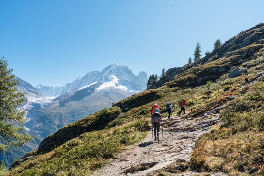
1. Tongariro Northern Circuit, Central North Island
The first of the overnight hiking adventures on the North Island of New Zealand that I would recommend is the Tongariro Northern Circuit, which is the most renowned Aotearoan adventure.
Hike around the warrior mountain
The active volcano, Tongariro, rises over the landscape of North Island watching like a ruler over its homeland. Per the Ngāti Tūwharetoa legend, the four pillars of the central plateau once flocked together. Tongariro, Taranaki (Mt. Egmont), Tauhara and Pūtauaki (Mt. Edgecumbe) were head over heels in love with Putauaki which led to a war. Tongariro came out victorious and remained forever close to his beloved maunga (“mountain”) while the other three slunk away, still moldering in grief at their present day coordinates west, north and east.
Because of the Māori cultural and spiritual significance, Tongariro National Park was established in 1894—the fourth in the world and the country’s first. The 25,000 hectares of park was announced as a UNESCO dual World Heritage site in 1993.
Walk into the belly of Māui’s fish
In the Māori tradition, the mountainous land and valleys are a result of Māui’s greedy brothers hewing and scraping flesh from the captured fish. From frozen snow summits to evaporating mountain fumes, reddish mountain hues to turquoise waters, barren wildlands to lively weald, you’ll encounter outdoor phenomenons as compelling as the legends themselves.
Traditionally the trail begins and ends at Whakapapa Village and encircles Mount Ngauruhoe (Mount Doom in the Lord of the Rings). The circuit is usually covered in 3-4 days with halts at the Mangatepopo, Oturere and Waihohonu huts.
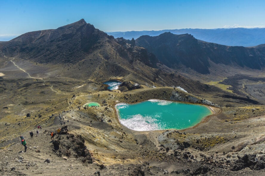
Leaving the starting point, you trudge into a volcanic world of eroded lava flow. The conical Mount Ngāuruhoe dominates the view, even after you have crossed the high point, Red Crater at the pass between Mt. Tongariro and Ngāuruhoe. What seems like a strenuous uphill is actually a tiny challenge compared to the delightful Emerald (Rotopounamu) and Blue (Te Wai-whakaata-o-te-Rangihiroa, “Rangihiroa’s Mirror”) lakes you’ll find. The water accumulated in the craters gets its teal identity from dissolved minerals from the thermal activity higher up.
The down climb from the lakes takes you through loose scree, and high-quality ankle-length shoes prove useful here. Here you come across the Tongariro Alpine Crossing trail, the shorter version of this multi-day hike (I will cover that in the following section).
As you move ahead from Oturere you will notice the shift in spectacles. The desert-like rocky patches now blossom with beech forests and bushes of daisies bundled with babbling streams. The green shade is refreshing as you move towards the end of the circuit. Stepping out from the volcanic world, make sure to take in the oxidized red crown of Ngāuruhoe with views of Mt. Ruapehu behind it.
Other things to do
You can also take a short detour to the Tama lakes and have a picnic at the foot of Taranaki Falls. The conserved area is known for its ski fields at Whakapapa and Tūroa on Mt. Ruapehu. If mountain biking interests you, be sure to visit the famous Old Coach Road track on the volcano. Only 4km from Whakapapa habitat is Tawhai Falls (featured as Gollum’s Pool in the LOTR). Additionally, check out Waitonga Falls and Silica Rapids not far from the village.
A word of precaution
Due to the geothermal activity, and for respect of Māori culture, do not touch the lake water or go near any steam vents. You also want to stick to the marked trails to avoid injury. Lastly, this is an active volcanic area: Te Maari, Red Crater and Ngāuruhoe vents have all been active within the last 100 years (the most recent eruption occurred from Te Maari in 2012).


Tongariro Northern Circuit, Central North Island - Good to Know
44.9km (27.9mi) loop. You can hike this in either direction
From 1,100m (3,609 ft) at Whakapapa Village to Emerald lakes at 1,886m (6,188 ft)
3-4 days
Moderate to Difficult
Rocky, loose scree to cemented trails
Late October to April or May. Winter crossings in the highpass get tricky due to heavy snow
Access from four locations: Whakapapa Village (SH48), Mangatepopo Road (off SH47), Ketetahi Road (SH46) and Desert Road (SH1, 35 km south of Turangi)
Huts (no camping allowed). Visit the Department of Conservation for booking
2. Tongariro Alpine Crossing, Central North Island
The Tongariro Alpine Crossing exemplifies what hiking in New Zealand is all about, which makes it not just our favorite but one of the best day hikes in the world.
Experience the red planet on green planet
The Tongariro Alpine Crossing offers many of the highlights of the Tongariro Northern Circuit in one of the best day hikes in New Zealand. This end-to-end trail typically begins from Mangetepōpō Hut and ends at the Ketetahi Hot Springs, which cuts off 8.5km (5.3 mi) of hiking from the beginning of the circuit. Starting this way requires less climbing than going in the other direction.
From the Mangatepopo Valley, pass through a tranquil landscape filled with pumice and lava streams. It is often sunny so be prepared to avoid sun burns. The first transition is up the Devil’s Staircase, a fairly challenging uphill climb, towards South Crater. Then the trail again goes into a small window of relief as you are strolling around huge open grounds with Mount Tongariro and Mount Ngauruhoe looking out for you.
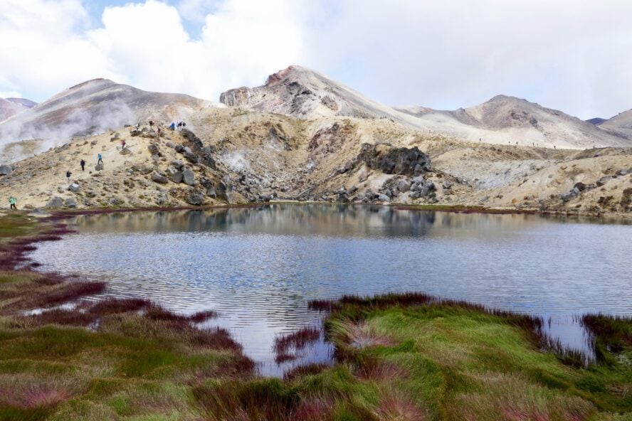
Following this is the hardest section leading to the Red Crater, the highest point on the crossing at 1,886m (6,188 ft). The climb is full of gravel and often, loose mud. Use the metal cable anchored on the sides as protection. Another breather comes with a small plateau and scenic views of the landscape.
If the up was hard you might feel climbing down even harder due to frequent erosion caused by hikers. A good pair of shoes, trekking poles and self-confidence is your best safety tool here. However, the moment you witness the heavenly water bodies all of the anxiety will fade away. It is amazing to find lavish teal and blue lakes amidst barren land.
Walking back through Rotopaunga Valley to Ketetahi Hut, you will instantly notice the dramatic switch in scenery. The tasaki grasslands with white daisies flowering and bunches of tussock will marvel, while the sunny weather typically turns windy and cloudy post-noon. By the time you finish you will be amazed at the diverse experience you just had: subtropical, desert, alpine and celestial in just 8 hours.


Tongariro Alpine Crossing, Central North Island - Good to Know
19.4 km (12 mi) one way
776 meters (2,546 ft), but depends on which direction you go
8-9 hours
Moderate
Rocky, loose scree to cemented trails
Late October to April or May. Winter crossings in the highpass get tricky due to heavy snow
Nearest entry point is Whakapapa village
Huts (no camping allowed). Visit the Department of Conservation for booking. Note that the Ketetahi Hut no longer offers accommodations after it was damaged following the 2012 volcanic eruptions
You need to hire shuttle to drop you off at the starting point
3. Lake Waikaremoana Track, East Coast
After circling the highlands this hike is more of a lowland, long-distance backcountry exploration along the western edge of Lake Waikaremoana and through the misty forests of New Zealand. Despite the popularity of the Great Walks, this is less visited which means no herds of photobombers for you.
A unique union
Te Urewera in the eastern part of North Island is home of the Ngai Tūhoe people (“children of the mist”) and nurtures millions of untouched species, podocarp forests (tall conifers and short hardwood trees with shrubs, ferns, grasses growing under their shelter) and beech greenery found nowhere on the globe. It is well known for its many lakes, the biggest and deepest of which is Lake Waikaremoana.
The National Park was formed in the 1950s, but was later dissolved. Since 2013, the joint board of Tūhoe and the Crown co-manage the conservation of their ancestral heritage with a unique partnership—it’s no longer overseen solely by the government. Now the forest is an independent legal entity unlike traditional government-run parks.
Here you’ll find a remarkable union of traditions with modern amenities (not luxurious, but certainly comfortable) with bush style camping, home cooked food and Haumapuhia legends.
Rainforest and ridges right from the lake
The trail does not round the whole lake, rather it tends the western edge in a semicircle starting from Onepoto in the south to Hopuruahine in the north. The reverse is also possible, although less popular.
You begin with a steep climb to the Panekire Bluff with magnificent vistas. The scary ridgewalk leads to Puketapu Trig, a bald knob that sits at 1,180 meters (3,871 ft), then on to the Panekire Hut. The next day will be underneath dark shades of beech, kamahi and moss-cloaked rimu trees, with lake glimpses in between, that sure feels like an avatar movie setup.
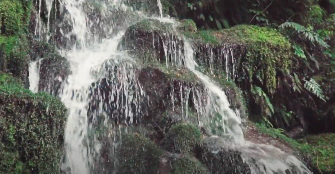
After climbing over Whakaneke Ridge, strolling on open grasslands and jumping over brooks you will land up on the lakeshore at Marauiti Hut. From here, you can take a short hike to Korokoro Falls—the water falling seamlessly like a thin white sheet, a definite must-go. Listen to the birds chirping, especially kiwi calls as you head towards the Puketukutuku Peninsula. After Tapuaenui Campsite, you finally stop at Hopuruahine Landing where the forest-walk ends.
Mind the weather
Waikaremoana, means “sea of rippling waters”, likely due to heavy winds over the lake that can bring sudden changes in weather. Along those lines, you might encounter knee-deep mud and snow patches, which is to say, plan for an unplanned adventure at any minute.
Other things to do
If there is a lake, how can there not be fishing? You can rent rods and enjoy a peaceful day out with a local fisherman. Make sure to get a fishing license beforehand though. Some other spots for you to check out are Wairoa Lighthouse, Te Reinga Falls, Kaitawa Power Station (for an olive green pool) and the Onepoto Caves.


Lake Waikaremoana Track, East Coast - Good to Know
46 km (28.6 mi) one way
600 meters (1,968 ft)
3-4 days
Easy to Moderate
The season generally runs from November and March
Waikaremoana is accessible by the SH38 which runs from Waiotapu in the north to Wairoa on the East Coast. Note that the highway is a gravel surface for a long stretch between Murupara and Tuai. You can also take a water taxi from Tūhoe to and from each end of the hike
There are five huts and five campsites on Lake Waikaremoana. They must be booked in advanced
4. Whirinaki Track, East Coast
If you are a regular hiker or climber you might have had one of those awakening moments of feeling negligible compared to gigantic mountain peaks. The Whirinaki Track offers another (yet similar) take on scale as you’ll walk among 65 meter (213 ft) mammoth trees, and under a towering primeval canopy.
Go green
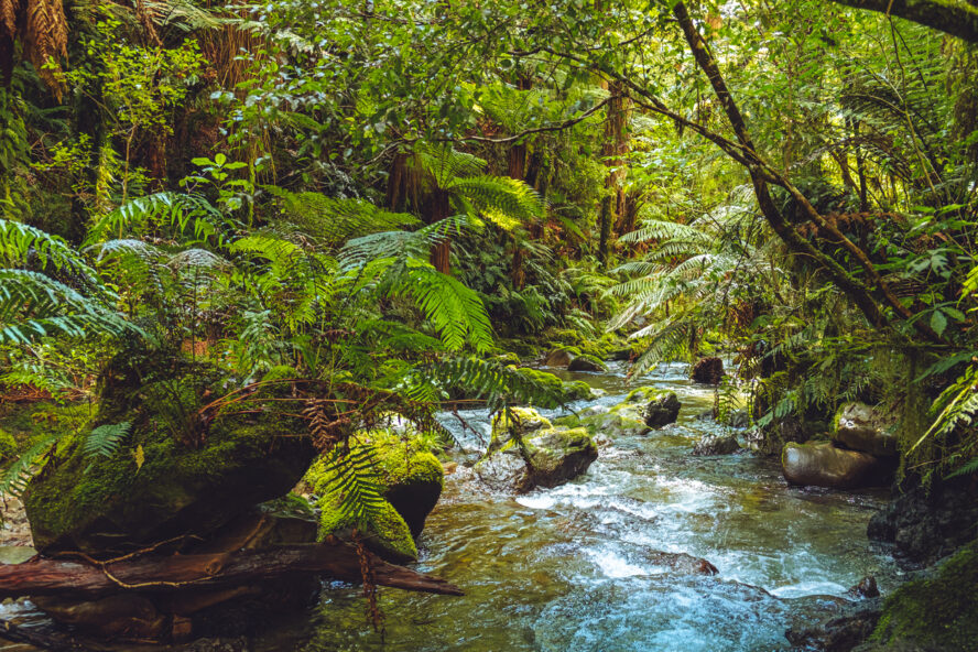
Whirinaki Te Pua-a-Tāne Conservation Park is considered one of the great forests of the world, with a well-graded path that takes you directly into the heart of dense stands of native podocarps, including kahikatea, rimu, miro, totara and matai. Among the primordial cone-bearing forests are innumerable plants, varieties of ferns, and rare birds, such as the whio (blue duck). It is particularly known for growing rongoā (“medicines”) still in use today.
Starting at the southern entrance at Plateau Road, you’ll follow a steady decline across the entirety of the 25.6km (16 mi) one way trek, with small climbs sprinkled here and there. The hike itself commences with a crossing of the Caves swing bridge along Plateau Road, named after a massive cave in the area that is silhouetted against a massive green backdrop.
Trudge along the right bank of the river to cross Taumutu bridge, then make your way to the Central Whirinaki Hut. Most people choose to stay here overnight, as it is the largest in the park. In the evening, head out to peep pekapeka (long-tailed bats) flying about.
The next day, continue north towards Vern’s Camp along an undulating path deeper into the forest full of waterfalls and mossy rock stairways. Keep a keen ear for songbirds such as kākā (parrots) and the friendly “cheet cheet” of the pīwakawaka (fantail). The trail is a mixture of dirt and layers of dry leaves like an aisle of potpourri specially curated by nature.
A few kilometers on, we recommend you take a 200 meter detour to Whirinaki Waterfall, an alluring spectacle. What comes next is Te Whaiti-Nui-a-Toi Canyon with remarkably stacked columns cloaked in a thick layer of moss, decorated with vines and white-water gushing below. There is a stairway to get into the canyon, just be cautious as it may be slippery. From here, take the bridge over the canyon to escort yourself to the finish at River Road.
Other things to do
The entire forest is a hub to explore, similar to some of the best hikes in Oahu. Arohaki Lagoon Track takes you to a shallow rain-fed pond and is a great chance to see birdlife such as blue duck, North Island kākā, red and yellow crowned kākāriki, kiwi and kererū. If you like waterfalls, you can hike to Waiatiu and Whirinaki falls.
Jump back in time to a Jurassic-like world of towering trees and million year old rocks.


Whirinaki Track, East Coast - Good to Know
25.6km (16 mi) one way
If you follow the route above, you will mostly be descending the whole way
2 days
Easy to Moderate
Lush forest, flat trail
The Track is 90km (56 mi) south of Rotorua. There is a northern entrance at the River Road car park, and a southern entrance at the Plateau Road car park
The Central Whirinaki Hut is the only serviced hut on the trail and it has bunk space for 25 people. Booking is required
Tips to Know Before Hiking in New Zealand’s North Island
The rule for hiking on the Great Walks in New Zealand is to prepare for all conditions. Along with that, here are some more things to know before you venture on an epic tramping adventure on the North Island!
What is the best time to go hiking in New Zealand?
The best time to go on New Zealand hikes is from mid-October to April, the spring, summer, and fall seasons in the Southern Hemisphere. Typically, during the summer, the west is more moist and experiences winds across the Tasman Sea. The east tends to be more dry. (This will reverse in the winter).
The following information is for the North Island.
Spring Hiking in New Zealand
Average temperatures run between 16-20°C (60-68°F) with an average rainfall of 9-12cm (3.5-4.7 in) per month. Days are getting longer and wind is starting to pick up from the west.
Summer Hiking in New Zealand
Average temperatures run between 20-24°C (68-75°F) with an average rainfall of 6-10cm (2.4-3.9 in) per month. January and February are the warmest months, with the sun hanging around up until 10pm at night.
Fall Hiking in New Zealand
Average temperatures run between 17-22°C (62-71°F) with an average rainfall of 9-13cm (3.5-5.1 in) per month. It is still often warm enough to go swimming, though nights are now getting chilly. By May, snow is starting to settle on mountain tops.
Winter is a popular season for skiing, but the hiking routes will often be covered in hard ice and snow.
What equipment should you bring on North Island hikes?
As the temperature can change in a matter of minutes you need to carry all the equipment you would for an alpine trek. From sun-protection against harmful and hot sun rays to extreme cold and winds (up to 65km/h). It can pour anytime so keep your waterproofs ready. Carry enough bottles for water to prevent heat exhaustion.
For multi-day hikes you want to be able to walk with 10-12 kgs (22-26 lbs.) on your back.
Here’s a list of the gear you want to bring:
-
- Backpack with a minimum 60L capacity and small day pack
- Day pack with a 25-40L capacity
- Sleeping bag (minimum 3-season, preferably down, lightweight)
- Hiking poles (optional)
- Gaiters (optional)
- Water bottle or CamelBak (2L capacity)
- Hiking boots or good hiking shoes
- Spare lightweight shoes or sandals
- Spare clothes for layering
- Thermal underwear (top and bottom)
- Shorts or lightweight hiking trousers (preferably quick-dry)
- Short-sleeved shirts (quick-dry, polypropylene, or wool)
- Warm fleece or wool jersey
- At least 3 pairs of socks
- Raincoat (Goretex or similar)
- Sunhat
- Warm hat or balaclava
- Gloves or mittens (wool or fleece)
- Swimwear
- Toiletries (sunscreen, hand sanitizer, bug spray, toilet paper, etc.)
- Headlamp or flashlight
- Sunglasses
- Camera (optional, but recommended)
How is the volcanic activity on the North Island?
Owing to the hanging danger of volcanic eruptions and geothermal activity, you must always follow the marked tracks. I suggest going with a group or a guide instead of venturing solo. Keep a safe distance from steam vents or lakes. Unless directed by a guide do not go for a swim in lakes or hot springs.
Why go hiking in New Zealand with a guide?
Because of the ever-changing weather and potential dangers from volcanic activity, I do recommend going with a guide, at least for part of your trip.
When the weather does not cooperate, your guide will know the correct course of action to take and they can update the day’s plans to take you to a more favorable location. Guides can also cater hikes to your fitness level and sense of adventure, and they often have working knowledge of the local customs, plants and animals, and history, so you can appreciate a deeper understanding and connection to the landscape.
Some New Zealand hiking etiquette to take note of?
New Zealanders are particular and proud of their ecosystem and are keen on building tourism while preserving the motherland. The “Tiaki Promise” is their way of involving each person as a guardian to protect and hike responsibly. It primarily focuses on the discipline of leaving no trace, respecting the local culture and caring for all. Kiwis present the Tiaki as a vero (“challenge”) to retain your commitment towards nature.
If you’re newer to hiking, we recommend you review these hiking tips for beginners to learn more about how to prepare, the principles of Leave No Trace, and other important details, such as how to layer your clothing.
It is also important to note that you need to book accommodation at huts or campsites in advance as there is no independent camping allowed—unless you are with registered tour operators. The entire Great Walks system is so in place that thousands of outdoor lovers around the globe sojourn for the gems of the eastern country.

What are the other activities to do in New Zealand?
There’s plenty more activities here. One of the most popular sports is mountain biking in New Zealand, which you can actually do in several of the locations I mentioned above. If you’d like to experience winter hiking in the summer, a heli hiking tour in Fox Glacier will take you into the foothills of the Southern Alps to explore the country’s longest glacier.

To stick with trekking, the New Zealand uncut hiking adventure will guide you to the highlights of both the North and South Island over two weeks. And if you’d like to just see more of Māui’s “boat”, try hiking and exploring the South Island which will have you canoeing in Milford Sound by Waka (traditional Māori rowboat) and circumnavigating in glacial lakes at Aoraki (Mt. Cook).
The People of the Land Are Inviting You
In this land of mythic proportions, it takes real care and stewardship to protect these places that spur imagination. New Zealand welcomes you to the country as manuhiri (“guests”) and kaitiakitanga (“guardians”) to contribute your bit to the conservation of world heritage, while enjoying the treasures of the Great Walks in New Zealand.