

The snowmobile tracks cut across the meadow like blackened road lines against a fuzz of green.
It takes moss decades to recover from human trammeling and while these fading marks were probably made twenty years ago the unfortunate blemish is a reminder of the landscape’s fragility. Think of a mosaic marred by graffiti or a broken marble sculpture in Greece or Italy. In our country the legacy isn’t built into the manmade architecture, it’s in nature itself.
While the island was forged by the harsh extremes of fire and ice, the landscape can be easily damaged. That’s why a quarter of Iceland’s territory belongs to national parks—and wild camping is strictly forbidden. Perhaps more than other nation, Icelanders share a special connection with their natural surroundings and take a great deal of pride in protecting them.
Case in point: this summer, I was guiding a group and we shared a hut with some locals. Among them was Iceland’s Minister of Foreign Affairs, of all people. Pleased to see visitors hiking in remote parts of the country, she talked about nature, for hours, with ease.
Hiking tours in Iceland aren’t just a gateway to experiencing its bewitching terrain, they’re also a way to understand the country and culture.

The Best Hiking is Found in Iceland
After hiking and guiding across the globe through places like Nepal, Greenland and South America, I have no qualms making a bold statement about the country I’ve been calling home since 2015: hiking in Iceland is unlike anywhere else.
Something new every day—or every few centuries
There is hardly any other place with such geological and visual variety. One day you are straddling a contrast of color—on a glacier in a sea of jet black sands—the next morning you are making your way through a remote trail carved by sheep—and enclosed by 6-foot walls of evergreen moss.
You could say the sheep themselves have explored more of the landscape than humans. There were, and still are, a myriad of places that are little known (or understood) by Icelanders—places surrounded in myths full of elves, giants, and other supernatural creatures. Walking in the Highlands and seeing all of these rock formations, lava fields, steaming vents, you cease to wonder why these myths were created in the first place. Due to the stories fueled by Nordic mythology and their general remoteness, many locations in Iceland have only been (scientifically) documented in the 19th and 20th centuries.
In other words, hiking in Iceland means discovering the lands for yourself.
Map of Hiking in Iceland
Below, each marker indicates a hiking area I’ll be chatting about.
Here you can see the locations we’ll cover below, and the sheer size of Vatnajökull National Park.
1. Vatnajökull Glacier
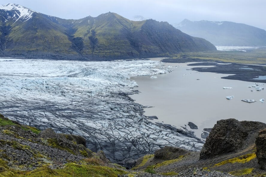
Hiking in Iceland is hardly imaginable without experiencing Vatnajökull—partly because it’s hard to miss. Covering almost ten percent of Iceland’s territory, it’s the largest glacier in Europe and boasts some of the world’s most beautiful glacial landscapes. In turn, the Vatnajökull National Park (around 15 percent of Iceland) encompasses the areas around Skaftafell (including the famous Jökulsárlón glacial lagoon) in the southwest and Jökulsárgljúfur in the north.
Now for some potentially disappointing news: hiking here is mostly confined to the areas around the glacier. If you want to go on the glacier, you need to be prepared for technical glacial travel aided by ice axes, crampons, and ropes. This is done only during summer and even then there are no guarantees that you will be able to experience Vatnajökull in all its frozen glory due to bad weather conditions.
But now for the good news: hiking around Vatnajökull is easily accessible and can take you to various outlet glaciers, ice caves, and waterfalls. For my money, it’s one of the best places in Iceland for day hikes.
Where to hike in Vatnajökull National Park
Close to the Skaftafell Visitor Center, you can find one of the highest concentrations of hiking trails in Iceland. I recommend you go to the outlet glaciers Morsárjökull and Skaftafellsjökull, the Svartifoss waterfall, and the climb up the Kristínartindar mountain.
You can also take separate hikes to the famous Jökulsárlón glacial lagoon with its luminous blue floating icebergs, or the Diamond beach—one of the most photographed (and photogenic) places in Iceland. Even though visiting these locations is better described as sightseeing than hiking, they are well worth your time. Other options include going to one of the ice caves around Vatnajökull. Note that you can only go to them with a certified guide!
A different Vatnajökull for all seasons
I want to add that there is no best season for visiting the Vatnajökull National Park—it depends on what you want to experience. Ice caves, for example, are only formed during the winter. You can also expect different landscapes in different seasons—icebergs turn from white to blue during the winter, while waterfalls have a lot more discharge during the summer.
If you want to go on the glacier, you basically need to be a diehard hiker ready to take on an expedition-style traverse. For others, hiking around Vatnajökull is easily accessible and still yields great experiences of glacial landscapes.


Vatnajökull Glacier - Good to Know
Easy to difficult
Most people stay in the area for one day, which is sufficient for one or two shorter hikes. If you want to do other activities, like visiting the Jökulsárlón glacial lagoon, the Diamond beach, or one of the ice caves, I recommend you stay for at least 2 days
Quite flat most for the most part. Hikes get more difficult because of their length, not the difficult terrain
Seals in the Jökulsárlón glacial lagoon
To get to the Vatnajökull National Park, most people fly into Keflavik International Airport, a 4.5-hour drive from the Skaftafell Visitor Center
Year-round
Camping available at the Skaftafell Visitor Center. If you don’t want to camp, you can find accommodation in Höfn, a two-hour drive from Skaftafell
The Skaftafell Visitor Center includes a cafeteria
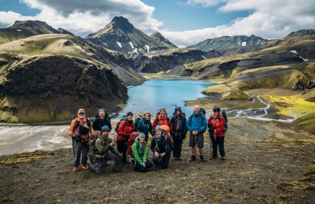
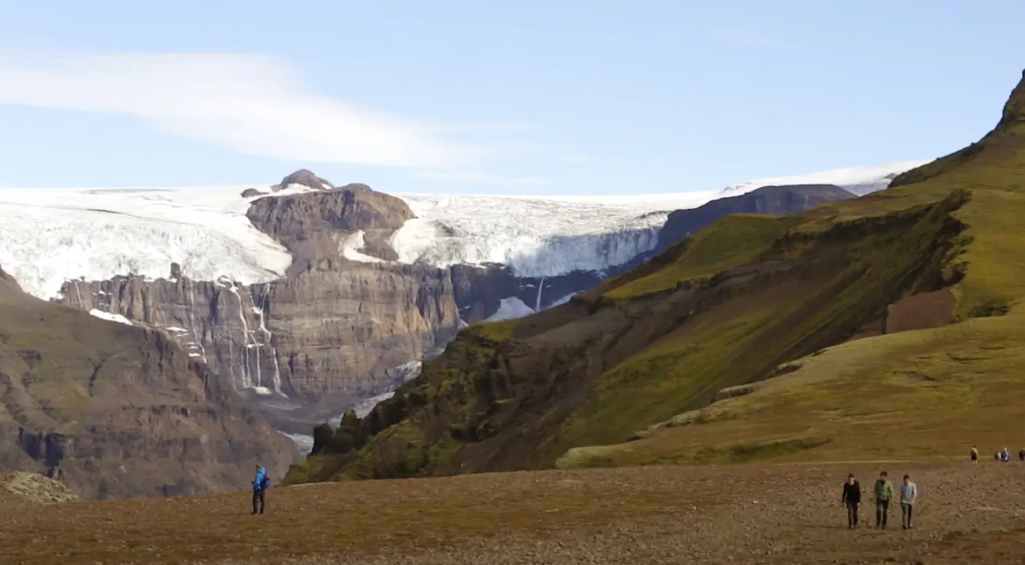
2. Langisjór

For me, Langisjór is the most beautiful place in the Highlands. Add to that its seclusion and you’ve got yourself some of the best hiking in Iceland.
Take a long look at Langisjór—from above
Translated as the “long sea”, this lake in the western part of Vatnajökull National Park is 14 miles (20km) of turquoise waters enclosed by mountain ridges.
Driving through the ancient moraines, you reach mossy slopes, yellow-black deserts, and patches of azure hues—occupied by a few birds, sheep and you (hopefully).
Since staying by the lake doesn’t grant the best views, you have to go up.
Traversing the slopes surrounding Langisjór is best described as uncovering one of the hidden hiking trails of Iceland. Hikes here can range between 6 and 22 miles (9.6 and 35 km) in length. I recommend you reach the highest point: Sveinstindur (3,580 ft / 1,093m). The elevation gain is only going to be around 1,150 ft (350m) though, since you start at 2,200 ft (670m). The hike starts near the campground (located by the westernmost tip of the lake) and will take you around one and a half hours to finish.
Beware that you’ll encounter cliffs and steep terrain—if you’re afraid of heights. Once you reach the top though, you’ll be rewarded with the best views of the lake, the Highlands (including Hvannadalshnúkur—the highest peak in all of Iceland), and even the Vatnajökull glacier (if weather permits).
And if you do like heights, consider climbing two other iconic Icelandic peaks to the west near Reykjavík: Mt. Hengill, for views of Lake Þingvallavatn and the distant Vestmann Islands, and the tempestuous 1,651m (5,417 ft) Eyjafjallajökull volcano, which last erupted in 2010.
A short and tempestuous season
As for the weather, don’t take it lightly. It is volatile and treacherous. A common thing that happens is that you get favorable skies and temperatures in the first part of the day, but then everything changes (it can happen in a minute)—you can get strong winds or easily get caught up in hail—even in late July!
Go off the grid
If you want to stay in the area for the night, make sure to have everything well-prepared in advance as it is one of the most remote areas in the Highlands. No phone connection, no restaurants, one toilet, one campground and that is it. The campground is literally a flat surface with no one working there. Oh, there is also one fishing cabin by the shores of the lake. If you want to stay there, make sure to book it well in advance!
No phone connection, no restaurants, one toilet, one campground—that is it. 14 miles of turquoise waters enclosed by mountain ridges—and occupied by a few birds, sheep and you (hopefully).


Langisjór - Good to Know
Moderate to challenging. Hikes are generally quite long
1-2 Days
Steep terrain with many cliffs. Not appropriate for children, people with no hiking experience, or people who are simply afraid of heights
The area is reached by a 4×4 vehicle, either on your own or as part of an organized hiking tour. It will take you around 4 hours from Reykjavik
June through mid-September. Langisjór is virtually unreachable past September
A campground or a fishing cabin (book in advance!) by the shores of the lake
You can’t buy food or drinks in Langisjór
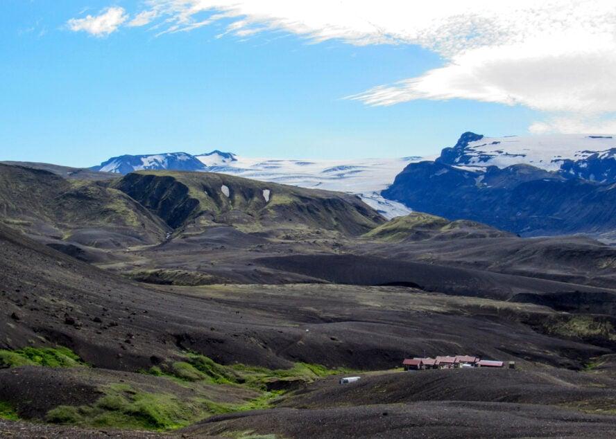
3. Landmannalaugar Valley

As the start of the Laugavegur Trail, Landmannalaugar Valley is possibly the best-known place in the Highlands, and generally one of the best places for hiking in Iceland.
It was created by a collapse of an enormous caldera a few thousand years ago, involving the eruptions of rhyolite lava—resulting in today’s orange, red, and yellow mountains There used to be a large ice cap covering the valley, the geothermal activity leaving its legacy in the form of hot pools. The subsequent eruption constituted the more common basalt—the black lava fields.
Historically, the area has been used as an oasis by shepherds traveling on horsebacks as Landmannalaugar is also full of pastures—and because they learned the advantages of hot pools early on.
More than just the start of the Laugavegur Trail
I used to work as a warden here and I know every single nook and cranny of Landmannalaugar. You can basically stay in the area for a week without having to repeat a single hiking route.
Most people visit by bus for a day trip from Reykjavik and stay in Landmannalaugar for some 5 hours, or to begin the Laugavegur Trail. That’s fine since there are great hikes that can be done in 2 to 3 hours by everyone—even the elderly. Taking a Landmannalaugar day hiking tour is also the simplest and the cheapest option as you don’t need to rent a car and equipment, or pay for accommodation.
Nevertheless, I suggest devoting at least two days. You should definitely hike up the Blahnúkúr—“Blue Peak”—one of the most fascinating sights in the area. Also, make sure to get some views of the Laugahraun lava field, traverse the colorful rhyolite mountains, and, of course, take a dip in the hot springs. If you seek the best possible views, you will have to go on more challenging—and much longer—hikes.
You can stay at the campground or in a mountain hut—book in advance and don’t expect luxury. There is a kitchen, a toilet and a shower, but unlike many huts in other parts of Europe, meals aren’t provided. If you are camping, you can still use the shared kitchen, but make sure to bring your own utensils.
Occasional storms
One of my most memorable experiences in the area was a storm which lasted for approximately 15 hours. Tents were broken and drenched and the campground looked like a battlefield—overnights sometimes get rough.
I used to work as a warden here and I know every single nook and cranny of Landmannalaugar. That said, I can tell you that the options are endless—you could basically stay in the area for a week without having to repeat a single hiking route.


Landmannalaugar Valley - Good to Know
There are many hikes which can be done by virtually anyone, but there are also longer and challenging hikes for experienced outdoor enthusiasts. One of the main things to watch out for are the weather conditions. You don’t want to get caught up in a storm anywhere but the campground/hut—it can be extremely dangerous
I suggest that you stay for two days
It can get quite steep, but really it depends on the hikes
You can get to Landmannalaugar by bus (a 3-hour ride from Reykjavik) or by a 4×4 vehicle (on your own or as part of a hiking tour)
June through mid-September. Winter in Landmannalaugar is reserved only for the bravest—or the craziest—as the area is regularly covered in 10 ft (3m) of snow. You can see pockets of snow in the valley even in the middle of summer
Mountain hut (book in advance!) and a campground. If you are traveling by yourself, there is another mountain hut 45 minutes away (by car). The second hut normally has more availability
During summer, you may stumble upon the Mountain Mall—three family-owned green school buses which serve soups and hot dogs. There is also one tiny store, one shelter, and a small cafeteria

4. Thórsmörk

Jagged black mountain ridges veiled in lush green moss. Electric blue rivulets set against black sand deserts. Powerful waterfalls overshadowed by mighty volcanoes. All on a backdrop of ever-white glaciers resting in the distance. Which is to say, Thórsmörk is probably the place that best encapsulated what people might imagine hiking in Iceland would look like.
One of the most striking aspects is how the landscapes change over the course of a year—something that is not as pronounced in other parts of the country. Here you can observe how native forests turn red during fall, search for wildflowers in spring and summer, and enjoy the most serene and downright gorgeous winter wonderland (good luck reaching Thórsmörk past October though).
Don’t I know that name from somewhere?
The story goes that Thor struck his hammer and—boom!—Thórsmörk was created. The common misconception is that its name translates into “Thor’s Valley,” but it is actually “Thor’s Forest”. It is located in the southern Highlands—at the end of a fjord and enclosed by mountain ridges. It is not particularly easy to reach as driving to it involves a few river crossings. However, it is one of the most popular hiking destinations in Iceland—also being favored by Icelanders themselves.
Inside the valley there are two mountain huts, but you can also find the “Volcano Huts” located on the other side of the valley. In my opinion, staying inside is a must if you want to truly experience this Icelandic gem.
Thunderstruck by uniquely gorgeous landscapes
Hiking here offers everything from easy half-hour strolls to moderate or even challenging climbs. One of the best hikes I recommend to everyone is the Útigönguhöfði peak from the Básar hut. The hike is not very technical, but it is quite steep and might take you a total of 4 hours or more to complete. Your reward will include some of the best vistas of the surrounding deep canyons and braided rivers.
For those with a bit more time, I highly recommend the 15-mile Fimmvörðuháls trail, which includes hiking up to the craters Magni and Móði (both were created in the 2010 eruption—the one that caused chaos in air travel). A general piece of advice is to seek hikes which allow you to experience the canyons (Stakkholtsgjá canyon in particular) and waterfalls (for example, the Skógafoss waterfall), and see the native forests and hanging glaciers.
The story goes that Thor struck his hammer and—boom!—Thórsmörk was created. A valley of mythic proportions fit for the gods.


Thórsmörk - Good to Know
It depends on the hike as there are hikes for all skill levels
At least two days
It can get quite steep. Make sure to check if the hike you are planning on doing is appropriate for your skill level
Thórsmörk is difficult to reach due to river crossings. You can take a bus from Reykjavik or go there by a 4×4 vehicle (either on your own or as part of a hiking tour). Many people also reach the area by hiking the Laugavegur Trail as Thórsmörk is its last section. If you go on your own, take extra caution as floods sometimes make the aforementioned river crossings impossible
Late spring through early fall
Two mountain huts “inside” the valley and the Volcano Huts located on the other side
Unless you are lodging in the Volcano Huts, you should bring your own food and drinks

5. Laugavegur Trail
Hiking the famous Laugavegur Trail is considered by many to be THE quintessential experience, and it is certainly one of the best hikes in Iceland. Its 35 miles (56km) are traversed over 5 or 6 days (seasoned hikers can finish it in as little as 3 though) on hut-based trips and are probably the best exemplar of my initial point about experiencing diverse landscapes.
Apart from the starting and ending points—Landmannalaugar and Thórsmörk—which are both covered separately above, every day makes you feel like you are on a different planet than yesterday. From luscious green canopies and colorful mountains, to turquoise lakes and obsidian fields as black as solar eclipse. Oh, I’ve forgotten about hot pools, gorges, petrified lava, ashen fields—and active volcanoes. In short, brace yourself for a sensory overload.
A good way to experience even more of Icelandic is by combining both hiking in Laugavegur and the South Coast of Iceland.
The best season to hike is from late June through mid-September. You can expect around 20 hours of light, temperatures around 50-55° F (10-13°C), and—as elsewhere in Iceland—highly varying conditions. Even snow is not unheard of.
Every day makes you feel like you are on a different planet. From luscious green canopies and colorful mountains, to turquoise lakes and obsidian fields as black as solar eclipse.


Laugavegur Trail - Good to Know
Easy to moderate. The trek is made easier by extending the duration
3 to 6 days, depending on your skill level
The terrain can get pretty difficult as there are some steep areas, as well as crossing glacial streams
The trail usually starts in Landmannalaugar and ends in Thórsmörk. You can do it in the opposite direction as well. You can get to either of these places by bus (from Reykjavik), a privately rented 4×4 vehicle, or as part of a guided tour
Late June through mid-September
Hrafntinnusker Hut, Alftavatn Hut, Emstrur Botnar Huts, huts in Thórsmörk (or the Volcano Huts)
You can’t buy food and drinks in most huts, so you should bring your own food and drinks for the entire duration of the adventure

Additional Information to Help You Prepare for Hiking in Iceland
We’ve covered a lot so far, but here are more general details to help you plan your trip.
When is the best time to hike in Iceland?
There is no “wrong” time to visit, it’s more a matter of preference—and cold tolerance.
Spring: April and May are considered the spring season, and this is when you’ll start to see migrating birds and early flowers, such as crocus and Easter lilies, appear. At this time you’ll have normal daylight hours, crisp weather (average of 39° F (4° C) in early April to 50° F (10° C) in late May), and less precipitation than winter or summer.
Summer: This is the prime time for hiking in Iceland, and when most people visit. From late June through mid-September, there are 24 hours of light and day temps are around 10-13°C (50-55° F)—though it can reach 77° F (25° C)—while the evening can get down to 41° F (5° C).
Fall: Autumn is another shorter season in Iceland, and generally runs from late August until late October or early November. Temperatures average between 32-50° F (0-10° C) and it tends to be more overcast and rainy. This is the best time for mushroom hunting and berry picking.
Winter: Ah, this is for the hardy, but also a great chance to see Iceland as most tourists don’t; when it’s a winter wonderland. The season is the longest, from November to March, with only about 4-5 hours of daylight, snow (of course), and it tends to be windier. The average temperature around Reykjavik is 32° F (0° C), though it can go as low as 23° F (-5° C), and sometimes up to 41° F (5° C). The more north you go, the colder it will be.
With all that said, you must plan for the extremes and varying weather conditions. Vedur and Belgingur are useful websites for checking the weather.
Can I hike anywhere in Iceland?
The short answer is no—you can’t just hike anywhere—but there are plenty of places where it is allowed. With three massive national parks and established long trails like the Laugavegur, you can find everything from short day hikes to multi-day treks in Iceland.
Is wild camping allowed in Iceland?
Remember, wild camping is not allowed in Iceland, per the terms of conservation legislation that was passed in 2015. With that ruling, it is now illegal to spend the night in tents, caravans, caravans, motorhomes or the like outside organized campsites or urban areas, unless the land owner or right holder has given their permission.
Do I need a guide to hike in Iceland?
The short answer is no, but you may want to. Going on guided hikes in Iceland is generally recommended here as it allows for a fuss-free experience and increases your safety. Guides can take you to places you would never discover otherwise (and which most locals don’t even know about, as you will find exploring the secret hikes of Iceland or on a hike and drive through the isolated parts of Iceland), or arrange easier alternatives if you are feeling tired one day. They can also estimate your skill level, and adjust the hiking accordingly.
In the winter, you should go with a guide. For starters, you absolutely need what I deem Super Jeeps (modified 4×4 vehicles designed to handle arduous off-road and winter conditions) to even drive on most of the roads (by law). To go on a winter hiking adventure in Iceland requires much more planning, skill at navigating icy roads and conditions, and specialized equipment. But it’s also when you are likely to have the trails to yourself.
Going on a guided hike in Iceland solves most of the problems around reachability or finding off the beaten path places.
What about gear?
You don’t need any special equipment or technical gear for most hikes—just your standard backpacking and hiking gear. The weather is extremely volatile, so make sure to dress in layers. You’ll alway need to have a base layer that wicks sweat off your skin; a middle layer that insulates and retains body heat; and an outer layer, or shell layer, that shields you from rain and wind; as well as a warm hat, sunglasses, and hiking boots. Depending on the location and duration of your hikes/treks and you may also need a large 30-45L backpack to carry your:
-
- Sleeping bag (good for 5-10℃)
- Spare clothes
- Proper hiking socks
- Compass and map or GPS
- Personal first aid kit
- Sandals or booties for river crossings
- Trekking poles
- Water bottle (you can often refill it from the glacier water)
- Headlamp
- Camera!
Safety advice
As was previously mentioned, I used to work as a warden at the Landmannalaugar mountain hut, and I have a few pieces of advice when it comes to safety. Hiking in Iceland is not like other places. Even seasoned hikers may be challenged by conditions found here; I’ve seen people that thought they could out hike a storm. They couldn’t. It is much better to wait it out in Iceland and return safely than risk injury in this kind of remote environment.
There are a few essential safety tips I tell everyone. Carry a GPS or map and compass, and know how to use it! If you are hiking unguided, load your GPS prior to traveling and have your hike planned out. Wikiloc.com shows great trail maps for Laugavegur and surrounding Highland areas. Submit your travel plan to SafeTravel.is. Check weather conditions at vedur.is. Notify the wardens or rangers before going to the next hut and bring telecommunication. Make sure you have the appropriate equipment, always bring food supplies, and never hike alone.
Understanding Icelandic culture and heritage
Hiking in Iceland is a must for those who are passionate about the outdoors, but also for those interested in learning about other cultures. Nature is their greatest heritage and, more than in any other country I’ve been to, experiencing it means understanding some core aspects of the country’s psyche. We can all learn from their example of respecting and preserving land; it’s all part of our identity after all.


