

It takes a lot to surprise me these days.
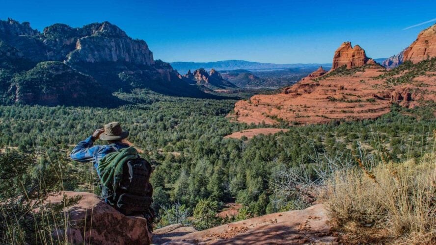
When a buddy of mine invited me to hike in Sedona, I expected little more than flat deserts rolled to the horizon… Instead, I was struck by the serenity—and variety—of it all.
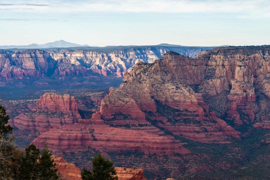
Located in the heart of the Coconino National Forest, the town is warded by massive sandstone formations glowing in brilliant orange and reds. Set against a blue sky, they look like fiery curtains of an ancient world. Turn any which way and you’ll see buttes and mesas rising out of the pine-dotted landscape, skirted by sage-scented trails that carry whispers of history.
Having traveled across 40 states and 15 countries, I thought I’d seen everything. But when I got my first taste of Sedona’s classic hikes, I became a convert to the Red Rock life.
Located 30 miles south of Flagstaff, Sedona is known among locals as a cathedral without walls. Looking out onto the arid landscape, there’s an air of the surreal—mystical even—in the intensity of colors and strange shapes. That may explain why Sedona has been the New Age capital of the US since the 1980s, with thousands of tourists flocking here every year in search of enlightenment, peace and spiritual healing.
You see, some people believe Sedona to be the site of mysterious vortices (or vortexes, as the locals prefer to pluralize it), swirling centers of energy flowing through the earth. These are located in Sedona’s most scenic spots, such as Airport Mesa, Cathedral Rock, Bell Rock and Boynton Canyon.
Spiritual or not, it’s hard to deny the impact of Sedona’s sandstone monoliths on the senses. On my first trip, all it took was a drive through Oak Canyon to seal the deal—I was going to move here and explore every corner of this astonishing place!
The Joy of Discovery In Sedona’s Rust-Laden Oasis
People in Sedona rarely spend their time holed up indoors; having world-class hiking and MTB trails right outside your door—and the Grand Canyon a 100 miles away—tends to do that.
Once I made the move, I wasted no time chatting up the locals to find out about the best trails, then trying them out one by one (the widely trafficked hotspots and unearthed gems alike). Soon I came to realize that each one holds little secrets: hidden caves, soaring pillars or new views that reward the adventurous—many of which we’ll talk about shortly.
Your Guide to the Best Hikes in Sedona
To help you plan your next trip, I’ve compiled a list of the best Sedona hiking trails.
While you can’t go wrong with any of these, you can make a mistake by underestimating the dry desert climate. Since you’ll mostly be walking among rocks and low bushes, make sure to stay hydrated and wear sunscreen. I suggest going on hikes early in the morning, when the temperatures are lower.
Easy Hikes in Sedona:
-
- Cathedral Rock Trail – 1-mile loop, best for butte lovers
- Devil’s Bridge Trail – 2.2 miles out-and-back, best for photo ops
- Boynton Canyon Trail – 6 miles out-and-back, best for shaded hiking
- Birthing Cave Trail – 2 miles out-and-back, best for hiking with your dog
Moderate Hikes in Sedona:
-
- Bell Rock Trail – 2-mile loop, best for vortex chasers
- Airport Mesa Loop – 3.2 miles out-and-back, best for panoramic views
- Soldier Pass Trail – 4.5-mile loop, best for diverse sights
Strenuous Hikes in Sedona:
-
- Bear Mountain Trail – 5 miles out-and-back, best for high mountain views
- Hangover Loop – 8.2 miles, best for hardcore hikers
1. Cathedral Rock

A sandstone shrine worthy of reverence
Cathedral Rock is a sandstone butte commanding the skyline in the southern part of Sedona. Just one look at its red-tinged cliffs is enough to make your heart race. Many tourists opt for a one-hour trip to the top to snap their photos as soon as possible, but I like to take clients on a more scenic tour. This includes a side trip to Oak Creek Village’s swimming hole for a refreshing dip, which adds a few hours and plenty of sights others often miss.
Making your way through the juniper and pinyon pines, you reach the bottom of Cathedral Rock. Here a dry wash marks a noticeable change in the terrain. The sandstone under your feet, worn out from the onslaught of tourist traffic, suddenly turns slippery. Then the toughest stretch: head up a steep cracked boulder and scramble over loose rock. This is the section where some beginners start to get discouraged. Luckily, the last push is rewarded with one of the most inspiring (and Instagrammable) views in the entire Southwest.
There’s another way of enjoying the beauty of Cathedral Rock: admiring it from the nearby Baldwin Loop Trail. This 3-mile hike explores the less-seen “backside,” an option for communing with the scenery away from crowds.
If you’re looking for classic Sedona hikes, you can’t go wrong with Cathedral Rock.
Andy Pickreign


Cathedral Rock - Good to Know
Moderate to strenuous
1 hour out-and-back, but can be extended with various side trips.
1 mile (1.6 km) loop
744 ft (227 m)
There are two designated parking lots at the Cathedral Rock trailhead. If there’s no space, you can try Yavapai Point Parking Lot, located around two miles south on Highway 179.
2. Devil’s Bridge Trail

Devil’s Bridge foretells trouble, but evokes delight
Considering how extensively photographed this bad boy is, chances are you’ve already seen it on a screensaver or a coworker’s new profile picture (inspirational quote and all).
Devil’s Bridge, the largest natural sandstone arch in the area, may seem intimidating at first, but don’t mistake its name as an indicator of difficulty. This staple Sedona hike is largely a casual affair with breathtaking views of Red Rock country and plenty of opportunities for wildlife watching.
It’s not long either, but just like Cathedral Rock Trail, it features a steep climb at the tail end; in this case, an uneven rocky staircase. Consider wearing hiking shoes for this one, or shoes with grippy rubber soles.
The trail itself is just under 2-miles roundtrip, but you’ll likely have to walk about two or three times that because parking spaces are a rare commodity. If you happen to have a 4×4 vehicle, you can drive straight to the trailhead and shorten your trip.
Another thing to note is that you don’t actually cross Devil’s Bridge. When it’s finally your turn to commemorate the occasion, you step onto the wide ledge—get your photo taken—then come back the same way. Now, I hope this doesn’t ruin the mystique for you: the trail is still gorgeous and the sights well worth it.
The spectacular view from Devil’s Bridge makes this one of the most popular hikes in Sedona.
Andy Pickreign


Devil’s Bridge Trail - Good to Know
Easy to moderate
Around 3 hours
2 miles (3.2 km) out-and-back from Devil’s Bridge trailhead, or 4.6 miles (7.4 km) if starting from the Dry Creek Vista trailhead
521 ft (159 m)
Drive down Dry Creek Road and park at the paved lot near the Dry Creek Vista trailhead. If you have a high-clearance 4×4 vehicle, you can park directly at the Devil’s Bridge trailhead, making the hike only 2 miles long.
3. Boynton Canyon Trail

Pay-per-view: One of Sedona’s must-do hikes (with a small cost)
Few canyon hikes near Sedona are reached by a paved road, but this one is! As a result, the pleasant, ponderosa pine-packed Boynton Canyon Trail enjoys considerable popularity among the locals. However, because the trail is located inside the Secret Mountain Wilderness, you have to pay a fee to enter.
Your hike starts in an open valley towered by red sandstone cliffs and skirts along the edge of Enchantment Resort before dropping down to the canyon floor, netting you some welcome shade. After that, the trail turns west and runs through a narrower canyon enclosed by dense rows of pine trees, climbing gently at first, then becoming steeper as you near the final viewpoint above the woods.
Once you reach the exposed rock face at the top, you’re treated to sweeping views of the canyon floor below and the surrounding desert wilderness. All that’s left to do is come back down and return to the starting trailhead.
The astonishing view from above the canyon easily makes this one of the best hikes in Sedona.
Andy Pickreign


Boynton Canyon Trail - Good to Know
Easy to moderate
2-3 hours
6 miles (9.6 km) out-and-back
500 ft (152 m)
Drive on Boynton Pass Road towards Enchantment Resort and you’ll find the trailhead just before the road ends. Parking is very limited, so consider taking the Sedona shuttle.
4. Birthing Cave Trail

Discover a hike that will make you feel born again
There’s a lot of hidden caves and tunnels to discover in Arizona. Among them, the Birthing Cave stands out as a uniquely beautiful and accessible spot. Known for its distinct opening, this sacred landmark is said to be a special place where pregnant Hopi women came to give birth.
You’ll be delivered to the landmark starting from the trailhead located about 15 minutes outside Sedona. For the most part, the journey involves walking on a flat, wide, sandy trail that hardly gains any elevation until the short final stretch.
You start the hike by following the Long Canyon Trail for half a mile before turning left at the first fork. After a while, the trail curves to the left with imposing cliffs rising to your right. A heart-shaped depression in the cliff will indicate the Birthing Cave. To reach it, follow a scrambly and somewhat slippery path to your right. Once you’re inside, take a seat on the sloping walls and admire the iconic view.
This is one of the best trails in Sedona for a quick and easy trip to a sandstone cave.
Andy Pickreign


Birthing Cave Trail - Good to Know
Easy
2 hours
2 miles (3.2 km) out-and-back
291 ft (89 m)
If you get there early, you might be able to park at a small dirt lot right next to the Birthing Cave trailhead. If not, there are some additional spots to the north, along the side of Long Canyon Road.
5. Bell Rock Trail

Ring in your hike with spectacular views atop Bell Rock
Just north of Oak Creek Village stands a peculiarly shaped butte, invoking images of a withered pyramid chipped away by time. This iconic formation is Bell Rock, a purported vortex site and one of Sedona’s most recognizable landmarks.
There are multiple trails leading here, but the one I take my clients on is the easiest of the bunch: a breezy 2-mile loop through shrub and sagebrush culminating with a glorious climb to the top of this imposing outcrop.
The Bell Rock Trail is well-traveled and not too strenuous. As a bonus, there’s a fun little scramble waiting for you at the end. All in all, this is a good time for the entire family. And if walking around in the Arizona heat gets your stomach churning, there’s a restaurant in Oak Creek called Corner Table where you can get some good old-fashioned American grub. Definitely try their burgers.
Those with more gas in their tanks can go check out Courthouse Butte, another geological jackpot in the vicinity. You’ll recognize this by its flat, box-like shape and horizontal multi-colored stripes.
When it comes to family favorites, the Bell Rock Trail is a ringing success for an easy Sedona day hike.
Andy Pickreign


Bell Rock Trail - Good to Know
Easy to moderate
2 hours
2 mile (3.2 km) loop (but you can reach the top in various ways)
475 feet (145 m)
You can reach the parking lot at Courthouse Vista by heading north on Highway 179 until you pass Bell Rock.
6. Airport Mesa Loop

Touch down at Airport Mesa for sweeping sun-soaked vistas
What if I tell you there’s a vantage point from which you can see the sunset’s low light reflected brilliantly by Sedona’s mineral-imbued sandstone?
The name of this place is Airport Mesa, a high flat-topped ridge with stellar views. It was renamed in the 1950s, from Table Top Mountain, when a small runway was built on top of it.
Offering a spectacular 360 of the area and peaceful meditation spots for vortex chasers, this 3.2-mile loop circling the upper slope is attractive not only for its panoramas but also for the beautiful display of wildflowers. Unlike the trails we’ve covered so far, the Airport Mesa Loop Trail is not suitable for beginners as hiking in the Arizona sun through rocky, narrow, and scarcely shaded terrain is no easy task. Plenty of water and a reasonable level of fitness is a must. The good news is that you get airy sights all the way through.
Its unique setting makes Airport Mesa one of the most interesting places to hike in Sedona.
Andy Pickreign


Airport Mesa Loop - Good to Know
Moderate
Around 3 hours
3.2 miles (5.1 km) out-and-back
416 ft (127 m)
Halfway up Airport Road there’s a parking lot with limited space. Further up the road there’s additional parking for a $3 fee, which nets you a daily pass with in-and-out privileges.
7. Soldier Pass Trail

March on through a desert Disneyland
Hiking the Soldier Pass Trail is like being on an amusement park ride—there’s always a new surprise waiting around the bend. Connecting several famous landmarks into a delightful 4.5-mile loop, this is hands down one of the best hikes in Sedona.
The first section is a short, flat walk to Devil’s Kitchen, a large sinkhole predicted to collapse even further. From there, a half-mile walk takes you to the Seven Sacred Pools, which are fed by a seasonal stream that provides water for the local wildlife.
Further on, you’ll find a fork in the road. What I like to do is take the right trail for a side trip to Soldier Pass Cave, a beautiful sandstone cave rife with photo ops, then return to the fork and continue left on the Soldier Pass Trail. The trail proceeds along a scenic ridge towards the Brins Mesa Trail, which is connected to your starting trailhead via the Cibola Pass and Jordan Trails.
Soldier Pass brilliantly showcases the richness of Sedona’s hiking trails.
Andy Pickreign


Soldier Pass Trail - Good to Know
Moderate
2-4 hours
4.5-mile (7.2 km) loop
840 ft (256 m)
There’s a very small gravel parking lot near the trailhead, but it’s currently closed. You’ll have to take the Sedona shuttle there and back.
8. Bear Mountain Trail

Find your bearings on one of the best trails in Sedona
If you’re looking to test your mettle, Bear Mountain Trail is among the more challenging hikes near Sedona. It’s a 20-minute drive from town to the parking lot near the trailhead, then 4-6 hours of leg-burning hiking to reach the top.
When you’re starting a trail and can barely see the summit directly in front of you, you know you’re in for a treat. A sequence of four steep rocky hills stands in your way, creating an escalating desert gauntlet packed with views and verticality. Once you finally reach the highpoint and take in the 360-degree view, you’ll roar with delight.
Keep in mind that you’ll need a Red Rock Pass for the Bear Mountain Trail. You can get one at a parking lot kiosk located off of Boynton Pass Road. Also, shoes with good traction are a must if you are to scale the steep rocky sections.
Even though it’s one of the toughest Sedona hikes, Bear Mountain Trail still sees a lot of visitors—it’s just that good!
Andy Pickreign


Bear Mountain Trail - Good to Know
Strenuous
4-6 hours
5 miles (8 km) out-and-back
2,000 ft (610 m)
Drive on Boynton Road to the parking lot at the Doe Mountain trailhead. The start of the Bear Mountain Trail is right across the road.
9. Hangover Loop

A heady trifecta awaits on Hangover Loop
My final suggestion is another strenuous loop—varied, challenging and crowd-free. There are three main sections in this roundabout trip: Munds Wagon, Cow Pies and Hangover. Together they provide around eight miles of gorgeous red rock and wildflower patches. And if you happen to be an MTB enthusiast, you’re in for a real treat because these exquisite trails are bike-friendly (but double black diamond, mind you).
Munds Wagon is a former cattle route with a surprising amount of elevation and a few switchbacks. This meandering trail runs parallel to the highly-trafficked Schnebly Road, even crossing it a few times. Eventually you’ll reach Merry-Go-Round Rock, an endless source of inspiration for wedding photographers. This small outlook offers picture-perfect views of Bear Wallow Canyon to the west and Munds Mountain to the south.
Before long a fork will take you to Hangover Trail. Here the steep climbs on loose rock will test your technique, while the accompanying views will fuel your determination. After about three miles, you’ll reach the Cow Pies Trail, a half-mile section connecting Hangover with Munds Wagon and the fascinating multi-level mounds on Cow Pie Mesa. Now all that’s left is heading on to Munds Wagon and following the trail back to the trailhead.
Three Sedona hikes in one scenic package—that’s what I call good value!
Andy Pickreign


Hangover Loop - Good to Know
Strenuous
4-5 hours
8.2 miles (13 km)
1,171 ft (357 m)
Take Schnebly Hill Road to reach the Huckaby trailhead. The remainder of the road is unpaved and mostly recommended for high-clearance vehicles.
Additional Information to Help You Enjoy the Best Sedona Hikes
What is the best time to visit Sedona for hiking?
Generally, March through May are the most popular months to visit Sedona because the temperatures are pleasant but not scorching. It’s also when nature is in full bloom, perfect for hikers on the lookout for scenic views. However, due to overcrowding in recent years, plenty of hikers have started coming in winter. It’s important to know that from December through February the trails might be muddy or icy in some places, so proper equipment and exercising caution is crucial.
Sedona shuttle service
Sedona has a shuttle service which runs year round, from Thursday through Sunday. It’s completely free, easy to use, and eco-friendly to boot! The Sedona Shuttle connects the main neighborhoods and some popular landmarks. Just note that there are long intervals between buses, so it’s always good to have a plan B.
Local etiquette: Let’s enjoy pristine nature and keep our trails clean
As guests of the land we are dedicated to preserving our natural environment and therefore practice Leave No Trace vigorously. Sedona gets quite busy during peak tourist season, which means lots of people on the trails. Unfortunately, not all of them adhere to the same principles. Don’t be like them. If you see trash, pick it up; if you bring it, take it back. Be respectful of your fellow hikers, don’t touch the petroglyphs, and make sure your dog is always kept on a leash.
What is Sedona’s wildlife like?
During your Sedona hikes, you’ll get a chance to encounter plenty of local wildlife. Coconino National Forest is home to many different species, including mule deer, javelinas (peccaries), coyotes, even bobcats and mountain lions, which are much harder to encounter. You can also expect to find plenty of insects, lizards, as well as a wide variety of birds, from tiny songbirds to large turkey vultures.
What should I pack for hiking in Sedona?
Here’s a list of the equipment you’ll need to tackle the best Sedona hikes:
-
- Water bottle or hydration bladder (2L capacity)
- Lightweight hiking boots or shoes
- Spare clothes for layering
- Waterproof rain jacket
- Sunhat
- Toiletries (sunscreen, hand sanitizer, bug spray, toilet paper, etc.)
- Headlamp or flashlight
- Sunglasses
- Camera — optional (but recommended)
Dress comfortably and for the weather in clothes you can move in. We suggest bringing clothing appropriate for the season. Layers are best and don’t wear jeans.
Is hiking in Sedona free?
You can visit most of Sedona’s hiking trails free of charge. However, there are 19 locations, including Cathedral Rock and Bear Mountain, where a Red Rock Pass is required. A daily pass is $5, a weekly pass $15, and the annual pass is $20.
What is Sedona like?
Life in Sedona is pretty far removed from the city. You won’t find big box stores here and there is no nightlife to speak of. Bars and restaurants close by 11 PM. That’s because Sedona is an International Dark Skies Community, which means even the streetlights are turned off to combat pollution and ensure a natural nightscape. Let me tell you, having backpacked the Alps and slept on glaciers in Washington’s North Cascades, nothing beats stargazing here in Sedona.
Where to go out in Sedona?
Northern Sedona is the busy downtown hotspot where all the tourist-oriented attractions and cool gift shops are. You can go there for food and drinks in the hotels and restaurants. But if you’re looking for the best bar in town, that would be Moody’s Irish Pub. This is where the locals come after work to chat up fresh faces and give them all the lowdown on the area. Take a seat, grab a bite and enjoy the lively atmosphere.
Where to stay in Sedona?
The hotels in the Village of Oak Creek, such as Sedona Village Lodge, are the best budget options for spending the night. For mid-range accommodation, you might want to check out Arabella Hotel Sedona or Sedona Views Bed and Breakfast. However, if it’s a dash of luxury you’re seeking, consider L’Auberge De Sedona or Whispering Creek Bed & Breakfast.
Additional activities to try in Arizona
There’s an incredible number of great hikes in Arizona to choose from. If you’re looking to get your feet wet with a multi-day adventure, backpacking in Paria Canyon might just be the perfect trip for you. For a refreshing change of pace, you can always check out the exquisite rock climbing in Arizona, and if you love to shred world-class hero dirt, you’ll be smitten with Sedona’s mountain bike trails.

There’s No Place in the World Like Sedona
Some people come to this town seeking spiritual enlightenment, others to frolic in the great outdoors, but in the end we all do the same thing—bask in the glory of these extraordinary red rock landscapes.
There’s a local saying that goes: “God created the Grand Canyon, but He lives in Sedona.” This alone tells you everything you need to know about the connection Arizonans feel to this magical chunk of desert.
Ready to experience Sedona’s otherworldly landscapes and hike on stunning red rock trails? Join Andy and book your adventure today!


