Thru-hiking the 2,200-mile Appalachian Trail (AT) is a dream for many hikers, but if you’re like me and can’t carve out six months away from your everyday life, section hiking the trail is a more feasible option. More than 40 miles of the Appalachian Trail pass through Maryland. Following the backbone of South Mountain, I recommend this stretch of the AT for the best hiking in Maryland.
The Appalachian Trail in Maryland provides countless hiking opportunities from the Mason-Dixon Line to the Potomac River. And lucky for me, Maryland is home to several spectacular overlooks along the AT, all located about 60 miles from Washington, D.C. Depending on your hiking ambitions, you can plan a short hike, a day hike or an entire weekend of backpacking, and enjoy some of the best hikes in the US. Here are a few of my favorite trails to explore:
1. Weverton Cliffs
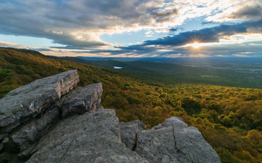
The three-state panoramic view on the Weverton Cliffs hike, just off the Appalachian Trail (AT) in Maryland, is nothing short of spectacular in any season. It’s my favorite spot to enjoy stunning sunrises and sunsets with wide sweeping views of the Potomac River below, which overlooks Maryland, Virginia and West Virginia. Summer sunset hikes to Weverton Cliffs are my absolute favorite. But, I find winter sunrise hikes, when there’s a fresh blanket of snow on the ground, to be equally breathtaking. In the springtime, beautiful wildflowers line the trail’s edge leading up the mountain. Don’t leave your camera at home for this hike. And if you use your smartphone to take photos, make sure you master its panoramic feature before you go!

Starting at Weverton Road makes for a short day hike on the AT
Marked with blue blazes like all side trails, Weverton Cliffs is just a stone’s throw off the Appalachian Trail. Most hikers gain access from the south, heading northbound, which is a short but steep climb with a huge payoff at the top. From Weverton Road, the hike to the cliffs and back is only about two miles round trip. I recommend this section due to the short distance — like the Superior hiking trail in Minnesota, it makes for a great hike for beginners and families who are willing to put in a bit of a workout. The trail terrain is rocky and narrow in sections with significant elevation changes, but I find the climb eases up on the switchbacks.
Start at Harpers Ferry trailhead for a more challenging Weverton Cliffs hike
If you prefer longer hikes, I recommend starting in Harpers Ferry and heading northbound to Weverton Cliffs. You can also hike southbound from Gathland State Park to Weverton. Not only will you rack up more mileage, but if you start in Harpers Ferry, you’ll be able to say you were in four national parks units in one day: Harpers Ferry National Historical Park, Chesapeake & Ohio Canal National Historical Park, the Potomac Heritage National Scenic Trail and the Appalachian National Scenic Trail.

My tips for hiking Weverton Cliffs on the Appalachian Trail
The AT from Weverton Road up to the cliffs can get busy at times, especially on the weekends in the spring and summer. I recommend an early or late start time or hiking during the week as opposed to the weekend if your schedule permits. Even though it’s a short hike, bring a snack or a journal. Once you see the view, you’re going to spend some time soaking it all in. On your section hiking tour of the Appalachian Trail, keep in mind that the trail is marked with white blazes, including the section that is on the C&O Canal. All side trails, like the Weverton Cliffs Trail, are marked with blue blazes.


Weverton Cliffs - Good to Know
Beginner to intermediate hikers
Rocky and sometimes narrow trail with lots of trees
750’
Weaverton Road Park & Ride for northbound hikers; Gathland State Park for southbound hikers
A wooden sign with blue letters directs people to the overlook
Any
Black bears, copperheads, ticks and timber rattlesnakes
2. Annapolis Rock/Black Rock Cliffs
If you’ve ever seen photos of an overlook on the Maryland section of the Appalachian Trail, they were probably taken at Annapolis Rock. I can’t stay away from Annapolis Rock and Black Rock Cliffs — just one mile apart on the Appalachian Trail — due to striking views of rural Maryland. My go-to route for access to both of these views is hiking the Thurston Griggs Trail to the AT. We then head southbound, first to Black Rock and then to Annapolis Rock. The Thurston Griggs Trail is a moderate, rocky climb any time of year, but it can be especially tricky in the fall when fallen leaves can betray your footing.
You’ll also find several small water crossings along the way. If you enjoy peace and solitude on the trail like I do, this is definitely the route to take. For me, the soothing sound of trickling water and wildlife are icing on the cake.
Annapolis Rock is a popular section of the Appalachian Trail
I recommend starting early or hiking to Annapolis Rock on a weekday because there are only a few parking spots at the Thurston Griggs trailhead, tucked away at the end of a residential street. The vast majority of hikers heading to Annapolis Rock start at the parking lot off of Maryland Route 40, just east of the entrance to Greenbrier State Park. Despite the large lot size, it fills at peak times, especially on Saturdays and whenever the weather is good. I find this also translates to a very busy section of trail on the AT, excluding cold and bad weather days.
Starting at Route 40 for the Annapolis Rock hike
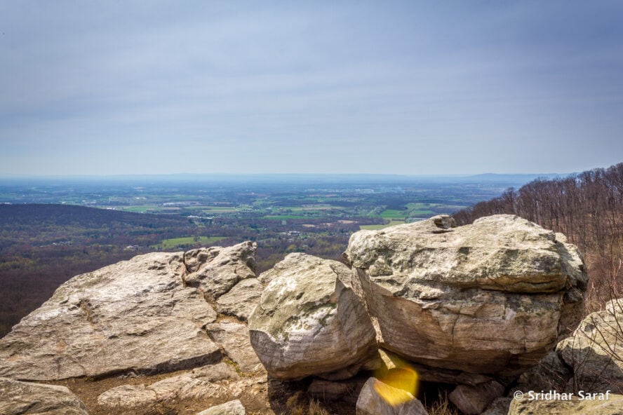
My recommendation is to hike from Route 40 to Annapolis Rock, which is moderate and gradual with a few steep sections. You’ll pass a low lying section that is frequently wet and muddy, depending on rainfall. Part of the trail often freezes and becomes a slick stretch of land during the winter months. Once you work your way up the mountain, the blue blaze side of the Annapolis Rock hike is well marked, whether you’re hiking north or south on the AT. Once you turn onto the blue blaze trail, you’ll pass through a small camping area before arriving at the top of the impressive rock formations, also popular with rock climbers. On a clear day, the southeast view from Annapolis Rock is beautiful, looking out over Greenbrier Lake.
Black Rock is is a smaller but equally impressive viewpoint
Black Rock is located one mile north of Annapolis Rock on the Maryland Appalachian Trail. You might have a harder time finding the markers on this side trail to Annapolis Rock. You’ll want to be aware of the distance you’ve traveled and be on the lookout for a wooden sign with blue lettering. You’ll see a sign for hikers traveling both north and south, but they’re on trees several feet above eye level. Black Rock isn’t as large as Annapolis Rock but the view from there is equally as impressive with a 180-degree panoramic view looking west. From the highest rocks, you can still see Greenbrier Lake in the distance. Annapolis Rock is by far the busiest of the two overlooks when it comes to hiker traffic. I think of Black Rock as the perfect spot to stop, rest for a bit and enjoy your favorite trail snacks.
Things to know before hiking Annapolis Rock
A couple things you should consider: The Appalachian Trail is marked with white blazes and side trails with blue blazes. The side trails to Annapolis Rock, Black Rock Cliffs and the Thurston Griggs Trail are marked with blue lettering on wooden Signs. Signage for Black Rock, which are up on trees, can be difficult to see and easily missed, especially when trees are fully covered.
If you enjoy peace and solitude on the trail like I do, this is definitely the route to take. For me, the soothing sound of trickling water and wildlife are icing on the cake.


Annapolis Rock/Black Rock Cliffs - Good to Know
Beginner to intermediate hikers
Fairly wide path with some rocky sections
1820’ (trail to Annapolis Rock); 1800’ (Black Rock Cliffs)
Greenbrier State Park (for northbound hikers); US Route 40 Appalachian Trail Parking Lot (for northbound hikers); Thurston Griggs Trail (for southbound hikers)
The Appalachian Trail is marked with white blazes and side trails with blue blazes.
Summer, fall
Black bear, copperheads, ticks and timber rattlesnakes
3. High Rock
If you’re up for a challenge and want to tackle a more difficult hike, I suggest hiking from Pen Mar Park to High Rock, the highest point on the AT in Maryland. I’ll admit that the entire 40-plus miles of Appalachian Trail in Maryland are considered easy hiking when compared to the terrain of the entire trail. Compared to other trails in the region, however, I consider some sections of the AT in Maryland to be moderate to difficult. You can even hike 0.2 miles north and carefully cross the railroad tracks to reach the Maryland-Pennsylvania border — if you wanted to say you began your hike at the Mason-Dixon Line.
Why I recommend hiking this section of the Maryland Appalachian Trail
The High Rock hike begins with a beautiful view from the country park and starts out easy. Don’t expect for the ease to last for long because the terrain soon turns rocky. You then follow a 500 ft ascent through a boulder field where you really have to pay close attention to the white blazes to stay on course. This section of the AT has the most elevation change anywhere in Maryland.
High Rock features a steep climb to Raven Rock and a boulder field
If you still want a good workout but you don’t want to climb through the boulders, you can hike to High Rock by starting at Raven Rock and then travel northbound. Parking is available on the wide shoulders of Maryland Route 491. This hike is definitely a more scenic route to High Rock, especially if you appreciate geology. It begins with a steep climb before leveling out and includes a beautiful view from Raven Rock. You can take a side trail to see Devil’s Racecourse, an impressive boulder field where you can hear the water trickling from below.
Graffiti-covered rocks at High Rock are part of the iconic AT highlights
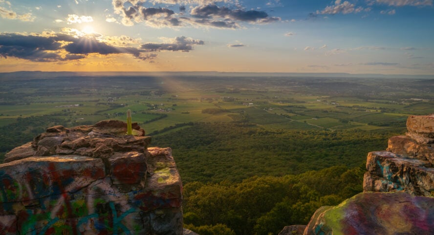
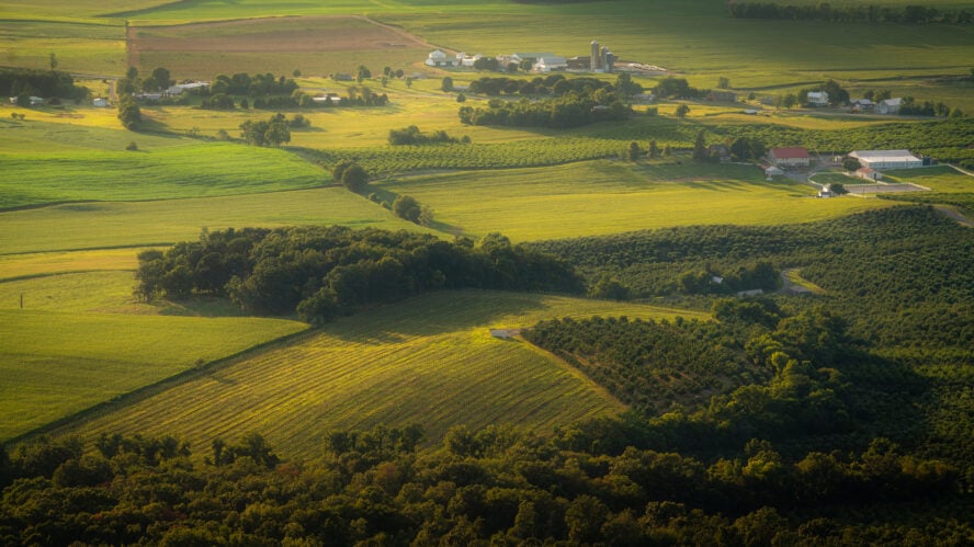
I recommend the blue blaze trail to High Rock because it’s well marked with the typical blue lettered wooden signs when traveling northbound or southbound on the Maryland Appalachian Trail. You might know about the iconic High Rock overlook because of its large graffiti-covered rocks on the Appalachian Trail. If you can get past the less-than-natural-looking spray paint, the view is really beautiful. Located on Mount Quirauk, you can see Waynesboro, Pennsylvania and the Cumberland Valley with panoramic views of rural farm fields below. Be cautious, especially when the rocks are wet, because the paint has made the rocks slippery. You won’t find a barrier at the edge.
Hang gliding is a popular option at the HIke Rock hike
High Rock was once a popular hang-gliding launch site that can now be glided via permit only. The overlook can get crowded because of vehicle access direct to High Rock, but I find the satisfaction of hiking so much better! If you’re camping or having someone shuttle you from High Rock to your starting point, plan to be there at sunset. I find there’s nothing like it!
If you can get past the less-than-natural-looking spray paint, the view is really beautiful. Located on Mount Quirauk, you can see Waynesboro, Pennsylvania and the Cumberland Valley with panoramic views of rural farm fields below.


High Rock - Good to Know
Intermediate
Rocky with large boulders
1905′ (trail to High Rock)
Maryland Route 491/Raven Rock Road (for northbound hikers); Pen Mar Park (for southbound hikers)
The trail to High Rock is marked with blue lettering on a wooden sign
Black bear, copperheads, ticks and timber rattlesnakes