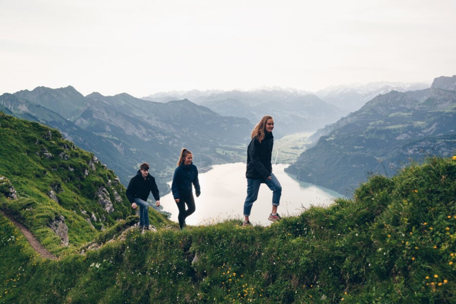

There’s a reason professional outdoor athletes like myself flock to Austin. Whether you’re sightseeing on foot or a local seeking a thigh-crushing workout, Austin has trails for every level of hiker. With over 300 days of sunshine per year and an abundance of trails, lakes, climbing areas, and swimming holes, it’s a city made for the urban adventurer. Top off your Austin hiking with some live music and tacos and you’ll be living like a local.

Whether you’re looking for a challenge, ready to swim and soak up the sun with friends as if you were hiking in San Diego, or want a family adventure that takes you past some of the city’s best sights, here are five of the best hikes Austin has to offer.
1. Mount Bonnell
Situated near the heart of the city, Mt. Bonnell is the highest point in Austin (775 feet). It’s one of the best places to get a skyline view of downtown, Hill Country views to the west, and Pennybacker Bridge over Lake Austin (part of the Colorado River). Mt. Bonnell is considered one of the best sunset viewing spots in all of Austin (or if you’re an early bird, sunrise). Best yet, this short but steep hike is family-friendly and dog-friendly (though because of the stairs, it isn’t great for wheelchairs or strollers). I recommend bringing a picnic (or take-out tacos).
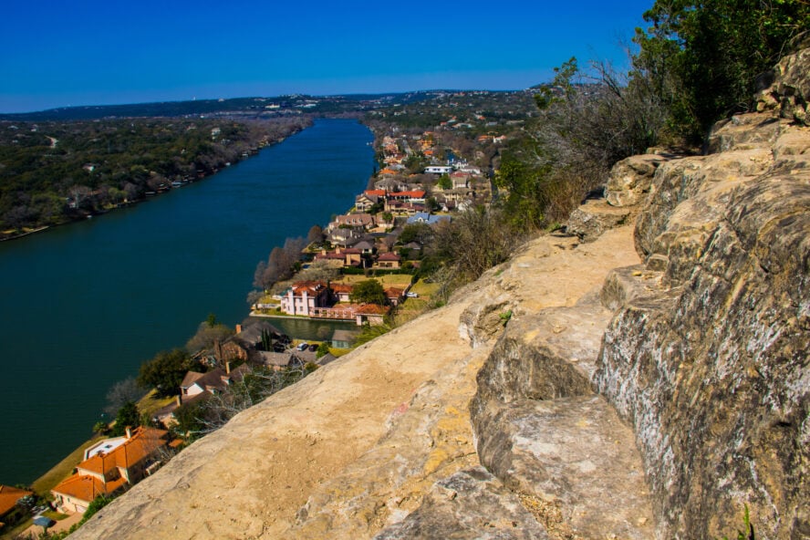
Located in Covert Park, to reach the summit, you’ll climb a wide 102-step limestone staircase to a viewing deck and pavilion. It’s mercifully mostly shaded. Stick to the stairs and main trail, which is well-maintained and easy-to-follow. There are some offshoot trails (which aren’t sanctioned) and come close to the cliffs, so I wouldn’t recommend them if you have little ones.
It can get crowded — but it’s worth it
Mt. Bonnell can get crowded — especially at sunset. But once you reach the top, you can see why the climb and crowds are worth it. Mt. Bonnell has attracted locals and visitors since at least the mid-1800s. These days, it’s a popular viewing spot for 4th of July fireworks and the ABC Kite Festival over Zilker Park in March. If you’re looking for a workout in winter months, join local runners, who enjoy doing laps on the staircase.
Mt. Bonnell is open from 5 am to 10 pm, so it’s perfect for sunrise and sunset watchers alike. I’ve found that if you’re trying to squeeze in a busy day of shopping, music, and restaurants, that it’s best to visit Mt. Bonnell early before other attractions open. It’s a great way to kick off the day and one of the best free things to do in the city.
Mt Bonnell is one of the best places to get a skyline view of downtown, Hill Country views to the west, and Pennybacker Bridge over Lake Austin.


Mount Bonnell - Good to Know
Easy to moderate
0.5 mile round trip, climbs 102 steps
Yes, for leashed dogs
None. Free parking along the street.
Year-round, though avoid mid-day in the summer when temps can get to 100F
3800 Mt Bonnell Rd, Austin, TX 78731. From the MoPac Expressway, take the 35th street exit west, passing Camp Mabry. Turn left onto Old Bull Creek Road and then right on Mt Bonnell Rd to the parking area on your left.
The closest bus stop is a 30 minute walk to the trailhead. If you’re visiting Austin without a car, use a ride-share or rent a car.
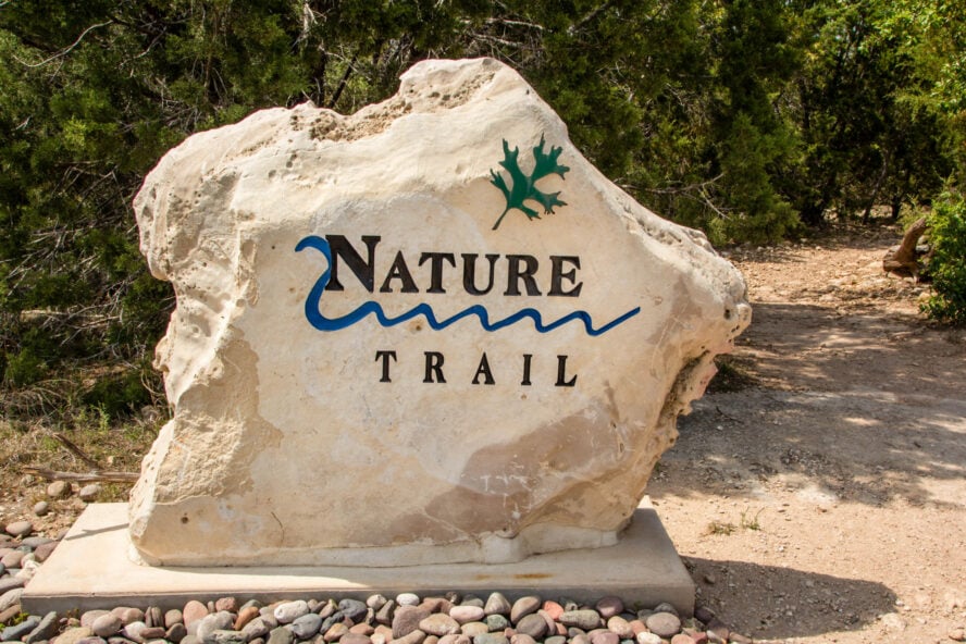
2. River Place Trail
One of the best places to get a quad-workout in town, the River Place Trail is the place to go in the city to train for the Grand Canyon or Guadalupe Peak. Like many locals, I like that by doing the Canyon Trail twice, it’s got almost the same elevation profile as the Grand Canyon or Guadalupe Peak in Big Bend National Park. Not bad for not having to leave the city! This shady but endurance-y hike is open to dogs (if they’re in shape!). Bring plenty of water, though. I feel bad for the humans and dogs who forgot their water in the car. Although folks will hike and run it year-round, if it’s not too muddy, the River Place Trail is an excellent Austin hiking trail in December.
The Canyon Trail isn’t just a locals’ training place for mountain hikes, but a scenic place to visit by itself. It gives a taste of Texas Hill Country without having to travel out of the city. You’ll cross small creeks on stepping stones, some which are worthy of a photo-op. Turtles bask in the waterways.
Be ready to climb the stairs
Don’t let the first of half of the hike fool you, though. The trail climbs log-framed wooden stairs through dense oak and mesquite forest. I counted 80 steps in a row, so be prepared to get a workout. Pass a small waterfall before topping out at the highpoint at Panther Junction at 900 feet.
This is one of the most well-groomed trails I’ve seen and it’s all maintained by volunteers. Worried about getting lost? Frequent trailside mileage signs show you how far you’ve gone and even have QR codes to pull up where you are on the trail map.
The best time to hike the River Place Trail
The only downside with the River Place Nature Trail is that it can get busy, especially on weekends. I recommend visiting on a weekday (when it’s free) or getting there at sunrise before the crowds. If you’re a faster hiker or runner, I’ve found that I had to wait to pass slower folks. Be patient and courteous — this is a popular trail and seeing other people is just part of the fun. There’s also quite a few dogs on this trail. Keep that in mind if you or your canine companions have trouble with other dogs.
Especially if it’s muddy, I recommend hiking shoes or boots with good traction for the River Place Canyon Trail. Not everyone I saw had trekking poles, but if you think it’ll help with the steps, bring a pair. Lastly, I can’t repeat it enough: don’t forget water!
By doing the Canyon Trail twice, it’s got almost the same elevation profile as the Grand Canyon or Guadalupe Peak in Big Bend National Park. Not bad for not having to leave the city!


River Place Trail - Good to Know
Moderate to strenuous
4.6 miles roundtrip and 1,300 feet of gain
Yes, for leashed dogs. There are many dogs here so you may want to avoid if your dog isn’t yet socialized.
$10 fee per person on weekends (card only — no cash). Residents can hike free with ID.
Spring, Fall
The Canyons Trail Address: 4740 River Place Blvd, Austin TX 78730
Little Fern Canyon is considered the most scenic in the River Place Trail System, but parking is limited at the Little Fern Trailhead. If you want to see it, park at the Panther Hollow Trailhead (it’ll only add a flat 1.0 mile to the Little Fern hike) or add it onto your hike of the Canyon Trail.
3. Barton Creek Greenbelt
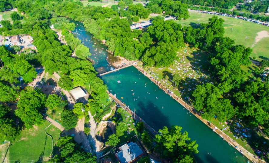
Barton Creek Greenbelt is a favorite hiking destination for locals and visitors alike. Starting at Zilker Park near Barton Springs Pool, this seven-mile trail (with an additional five miles on the other side of the river) hits many of Austin’s classic outdoor spots. That’s one reason it’s considered one of the best trails in Texas and Austin’s most beloved trail. The Greenbelt is popular with hikers, bikers, runners, walkers, swimmers, mountain bikers, and rock climbers (yes — there’s even a crag). With swimming holes, cliffs, and the 300-foot “Hill of Life,” it’s easy to see why this trail is the place to be in Austin.
The Greenbelt is 12 miles long — with extensions coming — but you don’t have to go the whole length to get a taste of what makes Barton Creek such a great place to spend the day. The Greenbelt has six access points, so you can hop off and on where you please. To avoid backtracking and to maximize the number of things you get to see, I recommend parking at one trailhead, hiking to another trailhead, and then ride-sharing back to your car (or use the bus stop at Zilker Park). Note: this works well for hikers, runners, and climbers, but is trickier for bikers.
Where to cool off with a swim
To get the longest hike possible, start at Zilker Park, home to the famous Barton Springs Pool. One of the top attractions in Austin, this limestone-lined swimming pool is fed entirely with water from natural springs. A year-round destination in Austin, its water temperature is always between 68 and 74F. Of course, the advantage of hiking the Barton Creek Trail is to find other less-trafficked swimming holes with no entrance fee. Locals each have their favorite spots along the creek.
From Zilker Park, it’s a flat 1.2 miles to the Spyglass Trailhead. I think it’s worth skipping unless you want the extra mileage. You can more easily access the popular Campbell Swimming Hole from the Spyglass Access Point. Continue south on the trail to pass numerous climbing and bouldering areas. The Gus Fruh Trailhead also has a deep swimming hole nearby and the famous limestone rock climbing cliffs with the great pun-ny name, Urban Assault. The main Loop 360 Greenbelt Access point has copious parking and access to the Seismic Wall climbing area. The Gaines Creek and Twin Falls trailhead have access to the Twins Falls swimming hole, but the trailhead can be tricky to find. If you want to hit Twin Falls, I recommend starting at a different trailhead and ending your hike at the Gaines Creek/Twin Falls trailhead. Let your ride-share driver use their GPS to pick you up.
My favorite Barton Creek trailhead
Trails End is a less-trafficked trailhead but my favorite because the geography is more diverse and it feels wilder, like Texas Hill Country. There’s easy access to the Sculpture Falls swimming hole and the 300-foot high Hill of Life. It’s common to see mountain bikers and runners climbing the hill looking for a challenge and workout.
Wherever you start or end the Barton Creek Trail, it’s easy to see why it’s Austin’s playground. In some parts, there’s trail on both sides of the river, so you can explore up to 12 miles of terrain. Just beware that there’s no restrooms, water, or trash bins along the trail and remember to keep your dog on a leash.
Wherever you start or end the Barton Creek Trail, it’s easy to see why it’s Austin’s playground.


Barton Creek Greenbelt - Good to Know
Easy to Strenuous
1 to 7 miles (multiple start and end points)
Yes, leashed dogs allowed
Some trailheads have parking fees (usually around $5)
Year-round, but it’s most fun on a sunny day after it has rained when the swimming holes are filled with water.
Numerous trailheads
If you’re hiking or running, use a rideshare service to pick you up at the end of your trip. That way, you can take a one-way hike and don’t have to backtrack.
4. Ann and Roy Butler Hike-and-Bike Trail and the Ladybird Lake Boardwalk
The Ann and Roy Butler Hike-and-Bike Trail and Ladybird Lake Boardwalk is considered “Austin’s most recognized and popular recreation area.” Locally called the “Town Lake Trail,” it’s one of the best hiking trails in Austin to see skyscrapers and lush nature. Since it’s an urban path right along the river (and built over the water!), there are even opportunities to get off trail and jump in a kayak or paddleboard. Although the full trail is a ten-mile loop around the lake, this flat and well-graded 2.2-mile hike hits the highlights and is suitable for families and people of all ages and abilities.
Even if you’ve visited Austin before, the boardwalk is new as of 2014. It won a Texas Society of Architects award because it’s designed to float and meander over the river like a hiking trail would do on land. The city commissioned artist Ken Little to decorate the boardwalk with western ranching-style belts cast in bronze with song lyrics from Texas singers and songwriters. This part of the trail is so fun that you can convince non-hikers to join you.
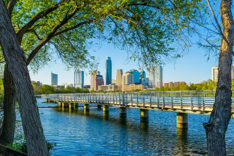
The Ann and Roy Butler Hike-and-Bike Trail runs ten miles around Lady Bird Lake (a dammed section of the Colorado River) — so you’ve got options of where to start and end. I like that the trail is in the middle of downtown, so it’s easy to access and tie in with other activities in the area. I like that it takes you through forested areas, panoramas along the water’s edge, and offers views of skyscrapers. The Ladybird Lake Boardwalk balances the feel of being in nature with the feel of being in Austin.
The best way to hike this trail
I recommend starting the trail at International Shores Park, dropping by Peace Point and heading west, ending at the Statesman Bat Observation Center 2.2 miles later. If you time it right, you’ll walk into the sunset along the boardwalk and end at the Bat Observatory right as the bats emerge from under Ann Richards Congress Avenue bridge. Home to the world’s largest urban bat colony, 750,000 to 1.5 million Mexican free-tailed bats fly out each dusk in the summer.
What I love the most about this hike is that it hits so many Austin attractions, but still feels like a way to get exercise and experience some peaceful nature. It takes you away from the cars and traffic stops and (best yet) is completely free. If you’re strapped for cash or just need to stretch your legs, I recommend taking a boardwalk stroll and visiting the bats. It’s a quintessential Austin experience.
What I love the most about this hike is that it hits so many Austin attractions. I recommend taking a stroll on the boardwalk and visiting the bats. It’s a quintessential Austin experience that’s completely free.


Ann and Roy Butler Hike-and-Bike Trail and the Ladybird Lake Boardwalk - Good to Know
Easy
2.2 miles one-way, flat (4.4 round-trip)
Yes, leashed dogs are ok
None. Free street parking along S. Lakeshore Blvd.
Year-round, summer for bat viewing
International Shores at Lady Bird Lake Metropolitan Park, 1800 S Lakeshore Blvd, Austin, TX 78741
Visit during sunset for views over the lake and to time your hike with when the bats emerge from the bridge
AustinTexas.Gov includes a free downloadable map
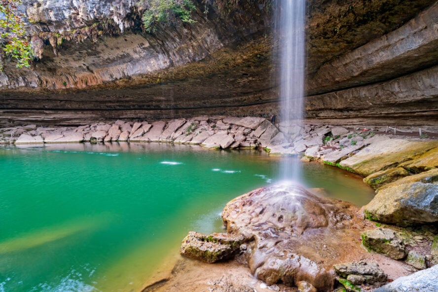
5. Hamilton Springs Pool
One of the best hikes near Austin, this short but steep and rugged trail takes you to a 50-foot waterfall and a 25-foot deep turquoise-green swimming hole surrounded by a limestone collapsed grotto. I think that the geologic features here would seem more at home in Thailand or Hawaii than in Texas. This is the hike to take to shower under waterfalls, bask on the sandy beach, or swim in a tropical-colored pool. The only downside is that depending on which season you are visiting, you will need to purchase permits online well in advance. Still, it’s well worth it for what is considered one of Texas’ best-kept secrets.
One of the best waterfalls and swimming holes near Austin
The trailhead starts at a rustic ranger cabin in the semi-arid uplands of juniper and oak savannah. These rolling hills and meadows are filled with native wild grasses and wildflowers that bloom in spring. Then, descend on rugged and steep trail through a riparian zone along Hamilton Creek — the source of the waterfall and pool. There’s hiking sticks available at the trailhead that can help on the descent. Finally, you’ll reach fern-covered limestone cliffs and the turquoise green swimming hole. A trail even curls under part of the collapsed grotto, formed by thousands of years of water erosion. (Geologists and the rangers insist that it’s a “collapsed grotto,” but I think it looks more like a limestone cave.)
See rare and endangered species
Part of the 31,000-acre Balcones Canyonlands Preserve, this area is home to rare and endangered species including the chatterbox orchid and the western-most colony of the eastern red bay. It’s also home to the federally endangered Golden-cheeked Warbler and many other birds. Check with the entrance desk if you’re a birder — they maintain a list of the many species seen in the reserve, including many who seasonally migrate through in the spring.
It’s worth noting that rangers test the pool’s water each day for safety. This should go without saying, but when the water is gross, you can’t swim in the pool. Often storms bring in runoff that contaminates the water, so check the weather a few days before you plan to visit. Still, the rangers insist that the park is just as busy with hikers on days when the pool is closed. Guided hikes are available every Saturday at 10 am. On other days, you can take a self-guided tour using the map available at the entrance station and follow numbered stops along the trail.
This is the hike to take to shower under waterfalls, bask on the sandy beach, or swim in a tropical-colored pool. It’s one of Texas’s best-kept secrets.


Hamilton Springs Pool - Good to Know
Moderate to strenuous
0.5 miles round-trip
No
Reservations required everyday between March and October and weekends and holidays November through February. Reservations must be made online. Expect to pay an online reservation fee, per vehicle parking fee, and/or a per person entrance fee. Some fees can only be paid online with credit/debit card and some are cash only. I found it confusing. More explanation of the fee structure explained here.
Late spring and summer (reservations required)
24300 Hamilton Road, Dripping Springs, TX 78620
Don’t forget your towel or swimsuit! Check the reservation system well in advance. Your online reservation covers only 1 vehicle and up to 8 people, so find your friend with an 8-seater truck and carpool down there together.
Find out about the Permit Reservation System from Travis Country Parks
My Tips for Hiking in Austin
The best time to visit Austin
Austin is a fun place to visit and live year-round. But if you’re timing your trip to get the best weather, most folks find temperatures are best during spring and fall. From March to May and September to November, it’s usually in the 70s or 80s during the day. Texas summers can be tricky for visitors — although that doesn’t stop it from being the most visited time of year outside of the big music festivals. In summer, Austin gets humid and is often in the 90s with afternoon rainstorms. October and March are considered by locals to be the best months because rain is less infrequent and temperatures are mild.
If crowds aren’t your thing, Austin sees the fewest visitors in December and January. Although Texans consider those months cold, depending on where you’re visiting from, it may be the balmy break you need. Aside from Barton Springs developed pool (which maintains near constant temperatures year-round), many of the swimming holes are too cold to enjoy. Still, it’s easier to snag a permit for some trails and you’ll sometimes have trails to yourself. Remember that if you visit in winter months, there’s fewer hours of daylight. Start longer hikes early and plan to be off the trails by twilight at 5:30 pm.
No matter what month you visit, if you intend to visit a swimming hole, be sure to check the weather beforehand. Flash flooding happens every year in Austin. It can be dangerous for hikers, bikers, and all outdoor adventurers. Check the weather a few days before your hike and be sure to check the day’s weather to determine if afternoon storms are coming your way.
Hiking in Austin with Dogs
Austin is considered one of the most dog-friendly cities in the U.S. — and that’s true for its trails, too. It’s common to see people running, biking, and going on hiking tours with dogs. You’ll even see dogs at the climbing crags and on paddleboards.
Hiking with your dog etiquette applies the same in Austin as anywhere. While Austin is one of the cities with the most off-leash dog parks anywhere, you’ll need a leash for most trails. Every city is a little different, so be sure to read up on local Austin dog etiquette before you go, too.
For dog owners, expect a lot of mud (and plan your car set-up or rental car set-up for that inevitability). Some places where your dog may want to swim, like Ladybird Lake, fluctuate in toxic algae levels, so check levels before Fido goes headfirst into the water. If you’re hitting a swimming hole along Barton Creek, keep an eye on your dogs to reduce the chance they’ll roll in poison oak.
One of the best parts of Austin for dog owners is that after you’re done hiking, Austin has among the most dog-friendly restaurants anywhere.

What to Pack for an Austin Hiking Trip
Austin is a laid-back and outdoorsy city, so you can wear some of your lifestyle-fashioned hiking apparel for daily use around town. A secure pair of sandals is a must if you intend to hike into Austin’s famous swimming holes. Luckily, those same sandals can serve as your daily shoes too (as long as they’re comfortable for walking). Don’t forget sunscreen and your swimsuit!
There’s plenty of sun here, so you’ll want a hat and sunglasses. If you forget them, it’s easy to find a trendy shop around town that can sell you an artistically designed trucker hat and sunglasses to complete your iconic Austin look.
How to get to trailheads in Austin
Depending on where you’re staying in the city and which trails you want to visit, I recommend that you rent a car. While there’s plenty of rideshare companies in town, some of the best trails are far from the city center. Those tabs can add up. Austin’s bus and light rail system is one of the best in Texas, but often doesn’t serve hiking destinations. If you’re only in town for a few days and are mostly sticking near downtown, you can see a lot by renting a bike or using one of the bikeshare services, like Austin BCycle.
If you’re new to hiking and need some additional info, check out these hiking tips for beginners.