I dip a blade into the river and am bathed in purity, as I imagine it feels to be plunged into Juan Ponce de León’s mythical long lost fountain of youth.
The icy spring-fed stream, in the middle of summer’s heat, is pulsing with runoff that crests the brim of my kayak and buffets my strokes. Every splash or involuntary capsize rejuvenates the spirit and, I like to think, restores my crows feet and creaky bones.
It’s something about the water. Maybe it’s in my blood.
As an Oregon native reaching back at least five generations, I know many of my grandmothers loved the rivers as much as I do; water skiing, catching crawdads and swimming the waterways kept them as young at heart as they keep me.
While all sorts of activities along the water’s edge can be soothing to the soul, there’s no replacement for the intimacy felt by kayaking in Oregon. And I am pretty sure if you take your own dip in our local drink, you’ll agree.
The Wild and Scenic Kayaking in Oregon
Oregon is world-renown for its prolific and pristine waterways. In fact, the state has the most Wild and Scenic river mileage in the lower 48 (2,173 miles to be exact), owing partly to the progressive-and-preservation-minded constituents. It’s also worth noting, Oregon seems geographically precocious when it comes to this type of terrain.
In addition to the fresh waters that hug their way down scenic mountains, gorges and canyons, the state is bordered by the Pacific Ocean. In between you’ll find alpine, desert and temperate forest, along with plenty of lakes to kayak in Oregon. Sometimes these are standalone units to paddle and sometimes they give way to each other along the trace of a river or coastline.
From the basalt rock river beds of Central Oregon to the lava tube river tunnels of the High Cascades, the unmatched scenery is what keeps me looking for the best places to kayak in Oregon. And where to kayak in Oregon is exactly what I will share with you.
1. Deschutes River, Central Oregon

I hail from Central Oregon and one of the reasons I moved there was all the great paddling accessible by way of the Deschutes River. From easy access day trips on the town section to remote multi-day excursions, there are kayak trips for everyone.
An oasis
The Deschutes River is a lush refuge in the arid and harsh high desert. Towering ponderosa pines and aspen groves line the banks intermingling with fairly fresh (according to geologic time) sharp ah-ah lava—flows which oozed from the Newberry Formation thousands of years ago. This lava creates an intricate network of tubes—bridges or tunnels—and bedrock which the river flows in and out of numerous times on its path to the mouth of the Columbia River.
During your time on the water you are sure to see great blue heron, osprey, belted kingfisher, beaver, otters, deer and even bighorn sheep in some locales, along with relics from by-gone railroad and timber operations.
Thrills accessible from town and beyond
Much of the river from its headwaters at Lava Lake to its middle section at Cline Falls State Park is flat water and easily navigable. My favorite stretch is central to Bend and located right in the middle of town: Riverbend Park to Bill Healy Bridge. This area can be paddled year round and is ideal in the summer. It is 1-2 miles one-way and is very accessible to newbies (note that if you’re just getting into the sport, you’ll want to read my kayaking tips for beginners to help you get started).
If you want to challenge yourself with a small thrill, paddle as far upstream from Riverbend Park as possible, until you hit a natural Class 1 rapid just upstream of Bill Healy Bridge. Try ferrying in and out of the small currents all channelized by fallen rocks and boulders in the river profile. Be ready for a fish tale or possible capsize. Consider wearing a skirt and helmet.
Towering ponderosa pines and aspen groves line the banks intermingling with an intricate network of lava tubes and bedrock all the way to the mouth of the Columbia River.
– K.M. Collins


Deschutes River, Central Oregon - Good to Know
Beginner to expert
It ranges from I to V with lots of choice of section and runs
Flat water, on a river with current. It’s best to paddle upstream first, if possible
The Bend Paddle Trail Alliance has a map/booklet which outlines the best places to flatwater paddle on the Deschutes River, especially on the upper reaches. The map is available for purchase at the Bend local paddle shop, Tumalo Creek Kayak and Canoe, as well as retail and hired
Fall. Central Oregon often has beautiful Indian summers filled with warm weather and colorful foliage
Depending on where you access the Deschutes River a Deschutes Forest National Forest Pass may be necessary. For details on keeping the Deschutes River healthy see the Deschutes River Watershed Council page
Accommodations are offered all over Bend. For the budget visitor Bunk and Brew Historic Lucas House is the hostel for you. You may even find a kayaking friend to paddle with there. Once you’re unpacked and settled in, go for a short walk to find one of three breweries downtown or one of the other 14 in and around Bend. My personal favorite spot for microbrews and crowd pleasing pub fare is Brother Johns (a nickname for Mount Bachelor, the Cascade peak from which much snow melt fuels the Deschutes). Or, try Deschutes Brewery, named for the river, obviously
Many roads lead to Bend, Oregon. It is in the heart and center of Oregon
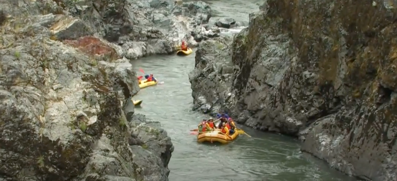
2. Rogue River, Southern Oregon

The Rogue River is the quintessential experience for kayaking in Southern Oregon. An original Wild and Scenic river designated for protection in 1968, the Rogue tends to define the pristine and untouched aesthetic kayakers seek.
A historic river known the world over
In the Siskiyou Mountains and Kalmiopsis Wilderness, the Rogue River has some of the most beautiful scenery of any river, in the state, or even the world over. Smooth and dark Madrone trees, various types of towering oaks and lush wildflowers all adorn a steep, and oftentimes, cliffed out river bank.
Stops at Whiskey Creek Cabin, Zane Gray’s Cabin at Winkle Bar and Rogue River Ranch—all in the National Historic Registry—are just a handful of the sites and buildings preserved by the Bureau of Land Management.
You can see it all in 3-5 days
The best way to see all 35 miles of the wild and scenic Rogue is on a commercial multi day river trip with a professional outfitter like OARS, the one I guide with. Recommended vessel? An inflatable kayak. Why commercial? The trip requires a lot of logistics and extensive gear. While some folks do organize private trips, they are incredibly experienced boaters. For most, a commercial trip is the best route.
An inflatable is my recommendation
Whitewater can be a tricky type of water to navigate in a rigid kayak. A traditional kayak requires expertise,like knowing how to roll and other maneuvers, for example, while an inflatable kayak is incredibly forgiving to a novice. It’s possible to traverse the Rogue River in a raft, but you’ll see and feel so much more navigating a smaller, more nimble vessel.
A range of rapids
On the trip you’ll experience all the rapids, from class I to class IV up close and personal with the watchful eye of professional raft guides hot on your tail in case anything goes sideways. Going into each rapid you and the other kayakers receive beta (or directions) from a guide and then try your hand at the rapid yourself. Meanwhile the guides carry all your belongings, food, camp equipment and everything but the kitchen sink on the rafts. The guides set up camp and cook the meals while you splish and splash.
Fine for beginners
Completely untrained novices sign-up for commercial inflatable kayak river trips all the time. During the most recent trip I guided, I inflatable kayaked Blossom Bar (class IV) for the first time. Guests aren’t allowed to kayak it (though they are allowed to paddle nearly everything else on the river) because it’s such a consequential rapid. Instead, guides paddle the kayaks past the biggest portion of the rapid called “the move” to ducky beach where guests are invited to get back in the yaks.
Initially I was incredibly intimidated but with a recent drop by a magnitude of 2,000 cfs (cubic feet per second) in water level, I found that the rapid was much easier in an inflatable kayak (than a raft) and I will be stoked to kayak the entire river someday soon.
Completely untrained novices sign-up for commercial inflatable kayak river trips all the time. The guides set up camp and cook the meals while you splish and splash.
– K.M. Collins


Rogue River, Southern Oregon - Good to Know
Novice to intermediate
Class I – class IV
All downriver with swift and whitewater currents. Steep cliffs, wilderness
Summer time. While the fall and spring are nice as well, the weather isn’t as consistent. You may experience the cold, rain, snow or all three
If you go with a commercial trip they will handle the permitting. If you go with a private group you will need to apply for a permit or get a cancellation permit at Rand
Many people fish on the Rogue River, typically on drift boat trips. For food and drink check out the west coasts famous In and Out Burger in Grants Pass. A quick stop into Sawyer Paddles and Oars in Gold Hill is also worth the thrill of seeing the digs of a homegrown southern Oregon paddle company. They can also outfit paddlers with last minute supplies
From Portland head South on I-5. From California, head North on I-5. Take the Merlin Road, exit 61. Stay in Galice or head all the way to the launch site at Grave Creek
3. Willamette River, Willamette River Valley

The Willamette is a 187 mile river which drains the northwest quadrant of Oregon through its floodplain, the Willamette Valley. This river valley is incredibly fertile making it for great agriculture including many vineyards, and it touches numerous cities on the I5 corridor. The Willamette is a thread of connectivity for anyone in its vicinity. It also goes right through downtown Portland, reminding me of Chicago River, one of the best kayaking spots near Chicago, although with fewer crowds.
Disneyland for boaters
Further up in the watershed there are some stout whitewater runs housed in a multitude of forks that attract hardshell enthusiasts (the real deal, big kid rapid-runners). Down river, towards the mouth, the Willamette is a haven for water skiers, trollers and other motorboatists.
The down river can be affected by the coastal pressure cells, gails and tides that ride upriver through the Columbia and haunt the confluence point near Sauvies Island, an area that doesn’t quite qualify as sea kayaking, but tidal and brackish all the same. Scappoose Bay makes a nice and super mellow half-day kayaking outing if you’re in the area.
Retrace the steps (and paddle strokes) of early settlers
When I think of the Willamette River, I think of fertile soils growing grapes for wine and monuments to historic events like Champoeg State Heritage Area. Kalapuya Indians, fur trappers, explorers and settlers all passed through the Willamette River Valley and you can retrace some of their steps by kayaking from Champoeg to Canby Ferry, perhaps a 5 mile jaunt down river.
Accessible terrain
This stretch of river has no whitewater though it is deep and wide. Not only does a Champoeg launch give you the chance to camp on-site and explore the park’s offerings like Manson Barn and Farmstead (a 1860s-style garden and barn) and the Pioneer Memorial Building (a pavilion and plaza on the banks of the Willamette marks the site of the famous 1843 vote that formed the first government in the Northwest), there are gorgeous wild pheasants roaming the premises and tons of facilities and amenities to be taken advantage of.
Having grown up in the Willamette Valley myself, just a stone’s throw away from Champoe in southwest Portland, the river holds lots of meaning. The McKenzie River, mentioned later in this article, drains into the Willamette and it connects to the Columbia which the Deschutes drains into. The Willamette has been a thoroughfare since the days of yore in what is now the I-5 corridor. It’s a common ground—or common waters oasis—that has connected river recreationalists, sleepy farm operators and urban commerce movers and shakers since time immemorial.
When I think of the Willamette River, I think of the Kalapuya Indians, fur trappers, explorers and settlers that all passed through the region.
– K.M. Collins


Willamette River, Willamette River Valley - Good to Know
Novice
Flat water, down river
Flat water with some waves and maybe white caps on a windy day
Willamette River Water Trail Map. You can find almost endless sample itineraries on the website
Summer time
A day use parking permit is required at Champoeg, see link for details
Check out the facilities, amenities and interpretive sites at Champoeg State Heritage Area
Take exit 263 along the I-5 corridor and follow highway 219 North until it dead ends at Champoeg
4. Columbia River, Columbia River Gorge in Northern Oregon

Scoured out by a flood of epic proportions, the Columbia River Gorge has a magnificence and grandeur rarely matched in the states, let alone the world. Paddling below its towering layers of basalt and paleo soils on either bank makes you feel infinitely small in the best possible way. There are innumerable put-ins and take-outs along the river, while the same is true for campsites at state parks, scenic viewing stops and other historic and interpretive points of interest.
Early explorers
Pre-Lewis and Clark, the reputation of Columbia River preceded it—select settlers in explorative circles on the east coast heard whispers of a massive water thoroughfare known as the River Oregon. When explorers like Peter Skene Ogden and David Douglas experienced the river, their records noted a cosmopolitan causeway with trading posts consisting of elaborate native commerce piggybacked by trappers. Innumerable languages were spoken and goods of all kinds proffered.
When I am kayaking in the gorge, I like to think about early peoples navigating the same waters by canoe, not for overblown romantic purposes but for business endeavors on behalf of their communities and families. Commuting back and forth as business professionals in their own right.
From my father to me to you
My favorite route to kayak was shown to me by my father—and that was shown to him by a long lost high school sweetheart (although he would never admit that). The put-in is at Rowena Ferry Road which terminates north on a peninsula jutting out into the Columbia River towards the Klickitat River on the opposite side of the gorge in Washington.
The crossing can take between 20 and 30 minutes in favorable conditions. Once on the other side, the mouth of the Klickitat River can shift and change between visits. Sometimes much sediment is built up and one might need to walk their kayak. When my father and I made the trip we found many birds and many blackberries.
Remember, you have to get back too
On the paddle back, white caps on the river had kicked up and the waters were far more rough than at the onset. It took us more like an hour to get back. During the return ferry my father was a bit ghost-faced and was white knuckling the paddle for fear of a capsize. Keep this in mind and be sure you are confident in your ability to traverse rough waters.
Despite the possibility of choppy and difficult conditions, I like this kayaking trip because I am most certain many before me had to venture across the Columbia in similar and worst circumstances. Imagining what those folks went through makes me appreciate modern gear, radar and instantaneous moment-to-moment weather reports.
I like to think about early peoples navigating the same waters by canoe, not for overblown romantic purposes but for business endeavors on behalf of their communities and families.
– K.M. Collins


Columbia River, Columbia River Gorge in Northern Oregon - Good to Know
Intermediate to advanced
More of a choppy waves sea kayak than a river/whitewater kayaking trip
Can be anything from glassy to choppy depending on weather, wind, tides and other variables
Early mornings or evenings
Depends on where you go, but not for the area mentioned above
Check out the hop and outdoor oriented towns of Hood River and White Salmon while your in the area
Take exit 76 off I-84 to access the Rowena Road put-in
5. McKenzie River, Cascade Range

The McKenzie River is a great place to crossover into whitewater. Just ask any Oregonian, and like me, they’ll say this is where they experienced their first rapids.
Dip your toes into whitewater
If you’re looking to challenge yourself and move from flat water to light whitewater, the McKenzie River from Forest Glen to Silver Creek is the perfect spot. The best part? There is actually an inflatable kayak on the market named the McKenzie, intended for this exact purpose. It comes in a single and a tandem, in case you want to brave things with a buddy. Coincidence, I think not?
Forest Glen to Silver Creek: Beginner friendly
Deep in the Cascade Range, meandering through basalt tunnels and popping in and out of the surface, until a recent forest fire, the McKenzie was also hidden in a shroud of underbrush. Post-fire it’s far more exposed and easy to scout from the highway that parallels it. The friendliest stretch to try your hand at whitewater on is Forest Glen to Silver Creek. The rapids top out at class II+ even during spring high water. That being said, check flows through American Whitewater and call the local ranger station for updates if it’s your first run. Note that wood or newly fallen trees can be a particular hazard in the spring—and anytime of year.
What you’ll love about this stretch as a beginner is that there are pools between each rapid so in the event a capsize occurs, you’ll have plenty of time to self-rescue and get back in your boat. Rapids like Frogger, Eagle Rock and Screamer will challenge your limits but are totally accessible to the well prepared novice.
Keep challenging yourself upstream
Once you’ve mastered this stretch, pick away at sections up river. The further you move up river, the more you will challenge yourself. I learned to whitewater kayak in this exact way with the help of Tumalo Creek Kayak and Canoe, mentioned earlier in the article.
Deep in the Cascade Range, meandering through basalt tunnels and popping in and out of the surface, until a recent forest fire, the McKenzie was hidden in a shroud of underbrush.
– K.M. Collins


McKenzie River, Cascade Range - Good to Know
Experienced flat water boater, novice whitewater boater
Class II+
Steeper gradient than flatwater, fallen logs and rock obstacles
See Soggy Sneakers: A Paddler’s Guide to Oregon’s Rivers guide book or American Whitewater
Mid-summer; the water is very cold here
None required for the section described above
The McKenzie River from Blue River to Forest Glen is a top notch section for a maiden voyage whitewater run. As kayaking skills progress, check out upper sections of the McKenzie River profile. Unwind at near-by Bag-by hot springs
Forest Glen and Silver Creek are both off 126
6. Clackamas River, Northwest Oregon

Located on the west side of the Cascade Range, the forests surrounding the Clackamas River are green and full of diverse plant life. The Clackamas is known as a classic Pacific Northwest River with great, intermediate Class III hydraulics in its upper reaches. On the lower plains, before the Clackamas outlets into the Columbia, the river calms and is ideal for floating or kayaking.
An epicenter of boating culture
Annually, the Clackamas River hosts Clack Fest, a boating festival with head-to-head, slalom and downriver races. In addition, the middle Clackamas is a favorite for sessioning and playboating, a form of kayaking where the boater faces upstream and practices doing tricks while surfing a wave or hydraulic.
Before kayakers sought out the Clackamas as a whitewater haven, 10,000 years ago it was inhabited year-round by Native American hunters, fishers and gatherers. Since that time the land near the river has been sold for logging purposes and even to early railroad companies. Most recently PG&E (Pacific Gas and Electric Company) has used the watershed for hydraulic power gathered through dams.
Dipping your toe in
Perhaps even more accessible than the novice-friendly McKenzie River run mentioned earlier, is the Clackamas section from Barton Park to Carver. Rated as a class II and only 5 miles long, this is a great stretch to get started on whitewater. Consider an inflatable kayak unless you already have experience in a hard shell.
While traveling down the river you may find you are accompanied by floaters. Although the stretch is lined in parts with houses, because of a dense forest it doesn’t have the urban feel of the Willamette. This is a very popular stretch after work or in the evening when the lighting permits. Since the river is fed in part by spring run off, expect it to feel more like Class II+ in the spring and more like Class II- in the summer. There may be times in the summer when flows are too low for the river to be navigable, hence its popularity with floaters.


Clackamas River, Northwest Oregon - Good to Know
Novice on the Barton Park to Carver stretch of water
II on Barton to Carver, up to V on the upper Clackamas
Pool drop with run outs on the lower section, more stout and difficult on the upper section
The best map and description is in Soggy Sneakers: A Paddler’s Guide to Oregon’s Rivers
Spring and early summer for best water flows
Standard invasive species permit, see below in additional information section
Just an an hour southeast of Portland, you can do this as an easy day trip from the city. And if you’re in the upper reaches near Mount Hood, check out some of the best rock climbing in Oregon at Trillium Lake Crag
Just outside Northeast Portland near Damascus, Oregon
Additional Information to Know About Kayaking in Oregon
There are a few things you’ll want to note about kayaking in Oregon before setting your GPS for Portland and heading out on the open road. Here’s a quick and dirty of must knows before you go.
Do you need a permit to kayak in Oregon?
Each river stretch likely has its own permitting system. Some might require a forest service or parks pass while others may require a recreation pass specific to the water way. A good way to check is by calling the local land manager directly or checking American Whitewater, which notes all stretches of water navigable in the U.S, current hazards and flows. The latter two bits of information are also important research before getting on the water.
Invasive Species Permit
A Waterway Access Permit is required for non-motorized boats 10 feet and longer. The Aquatic Invasive Species (AIS) Permit is included in Waterway Access Permits are required for paddle craft 10 feet and longer, and an out-of-state aquatic invasive species permit is required for motorized boats operating in Oregon waterways.
Safety: Wear your life jacket!
Bring and wear a life jacket or personal flotation device when you are kayaking. U.S. Coast Guard statistics show that drowning was the reported cause of death in 81% of recreational boating fatalities in 2021, and that 83% of those who drowned were not wearing a life jacket.
Remember your Leave No Trace principles
It’s best to take only memories and leave nothing behind while in the wilderness, on a protected river or outside anywhere. Check out the link for details!
A Refresher
Kayaking in Oregon is widely considered the pinnacle when it comes to paddling in the U.S. (to take nothing away from all the places to kayak in Florida, Colorado or elsewhere). Part of this is the many Wild and Scenic waterway designations and the rest is the nature of the landscape and countryside. Beaches, mountains, deserts and every type of terrain in between is woven with rivers, lakes and the sea.
If you haven’t dipped a kayak blade into an Oregon waterway and enjoyed the nurturing sway yet, I highly suggest you give it a taste. Who knows, you might just find your own fountain of youth.