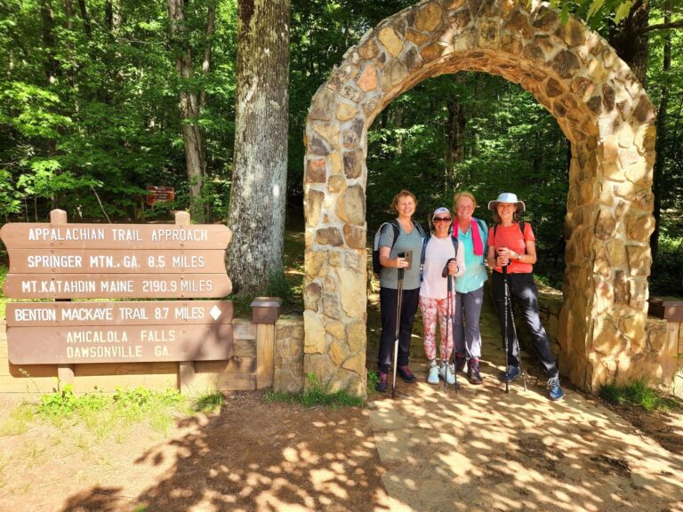
Prior to actually getting on the trail and starting your epic journey, you’ll have a 10-day orientation in Georgia to prepare. Over the first 3 days, you’ll go over gear, clothing, food, resupplies, and all the logistical stuff with the hike organizer and your fellow thru-hikers. Then on Day 3, you’ll shuttle to Amicalola Falls State Park, where you will register for the thru-hike. You will then hike up Springer Mountain in the afternoon, and on Day 4, you officially begin the hike! The guide will be with you for the first week, hiking along the A.T., making sure you’re comfortable and ready hiking alone.
-
The Appalachian Trail needs no introduction. Thru-hiking its 2,190 miles is on top of many bucket lists, but actually embarking on this 5-7 month journey is something only the bravest do—and only a portion of thru-hikers finish it. With a supported thru-hike of the AT, your chances of succeeding significantly increase. You’ll have your support vehicle—a motorhome where you store all your extra food, gear, clothing, and toiletries—meeting you every 1-3 days, and this will also serve as a security check. Once a week on average, you’ll be transferred into town, where you can resupply, shower, and do laundry. Embark on an epic journey and finish one of the most famed long-distance trails in the world.
-
The thru-hike, i.e. the orientation, will most likely start on March 30, 2025. If you choose this itinerary, you’re committing to the full thru-hike. Thru-hiking the Appalachian Trail is expected to last 5 to 6 months—the price covers the sixth month as well. During your time on the A.T., you will have a terrific support system, including a support vehicle, shuttles into town, logistics planning, and the orientation.
If you’re interested about what you can expect from hiking in each of the 14 states that the A.T. passes through, we encourage you to look it up—there are numerous guidebooks written about the trail and the internet is also a great source of information. Learn how to prepare for thru-hiking the Appalachian Trail and check out these 15 AT hiking tips for first-timers by a three-time AT thru hiker.
To learn more about what you can expect regarding the logistics of AT’s supported hike, scroll down and check out the FAQ.
-
-
You’ll spend your first month passing through Georgia and North Carolina.
Georgia is a fantastic place to get into the mindset of thru-hiking—the trail is wide and smooth and the terrain is relatively easy compared to the rest of the trail. You’ll begin your journey in Springer Mountain and soon you’ll get used to life in the wilderness.
Distance: 78.1 miles (125.7 km)North Carolina starts to give you an idea of (literal) ups and downs of the AT. Just south of the Smokies, you can expect long climbs and many scenic views. The NC portion of the trail continues along the border with Tennessee.
Distance: 96.4 miles (155.1 km)Keep in mind that the weather will be very cold with possible snow and ice at times. Average day temperatures could be anywhere between 20 and 50° F, while at night it could go down to 0° F.

-
Hike through your first trail town on the AT! These communities recognized as valuable places for thru-hikers, providing food, supplies, history, recreation, and much more. Once you’ve passed through the Smokies, the weather usually starts to warm up, and it could be time for a gear change.
Border of North Carolina & Tennessee runs along Great Smoky Mountains NP ($25 permit required), the most biologically diverse and the most visited national park in the States. Spectacular vistas are guaranteed, as you’ll frequently climb above 5,000 and 6,000 ft (1,524-1,829 m) and pass through the highest point of the AT, the 6,625-foot (2,019-m) Clingmans Dome. You’ll reach your first trail town, Hot Springs.
Distance: 217.8 miles (350.5 km)Tennessee welcomes you with the 2nd trail town of the AT, Erwin. Other than that, highlights of the state might be high-elevation summits, dense forests, and Laurel Fork, a serene gorge featuring 40-foot waterfalls. Hopefully, you’ll hit your 3rd trail city, Damascus, Virginia, just in time for a hiker festival, where you can expect a parade,arts & crafts booths, gear booths, prize giveaways, food trucks, and more!
Distance: 74.7 miles (120.2 km)
-
Weather begins to warm up so you’ll need to switch to summer gear, which means a lighter backpack! Average day temperatures are around 50 to 90°F during the day, while the night brings a bit cooler weather at around 40 to 60°F.
Virginia has more miles of the AT than any other state, accumulating nearly a quarter of the entire trail length, and it’s a place where you’ll spend at least a month. While Southern Virginia is a challenging section featuring long climbs along the Blue Ridge Parkway, Northern Virginia and Shenandoah National Park boast mellow sections on farmland and rolling hills. Exit the park around Front Royal, and you’ll soon enter West Virginia.
Distance: 541.7 miles (871.8 km) + 25.2 miles (40.6 km) along VA/WV border
-
In July, the weather starts getting hot and humid. Be prepared for day temperatures going above 85° F. The terrain starts to get easier and flatter, but the trail itself becomes rockier.
West Virginia’s section of the Appalachian trail is by far the shortest, but still very important for thru-hikers as they pass through Harpers Ferry. Apart from being a site of notable Civil War battles, it’s also home to Appalachian Trail Conservancy’s headquarters and a symbolic AT midpoint.
Distance: 2.4 miles (3.9 km)Maryland is a fan favorite—it hosts some of AT’s gentlest and flattest terrain, you can hike it in just 2 days, and it’s close to the buzzing Washington, D.C. Consider Maryland the calm before the storm, as you have the rocky Pennsylvania next up.
Distance: 40.9 miles (65.8 km)Pennsylvania, also known as “Rocksylvania”, is where you get to show what you’re made of. While the north features rocky terrain that’ll test your feet, southern PA offers some of the smoothest terrain of the whole AT. Factor in historic landmarks and charming towns along the way as well as expansive views off the top of ridges, and you’ll find that you have to gird your loins for Pennsylvania’s rewards.
Distance: 229.8 miles (369.8 km)
-
Longer days and flatter terrain during this month make hiking a bit easier, allowing many hikers to pick up the pace, with many covering 15-20 miles (24-32 km) a day. These states don’t have long stretches of the AT, so you’ll go through them in a matter of days to a week. The trail runs through populated areas, along roads, and through farmlands. Weather is still hot and water sources can be contaminated with farm pasture runoffs, so make sure you’re filtering your water.
New Jersey offers two great things: the feeling of remoteness in the wilderness and proximity to major cities. Elevation changes are generally moderate, and you’ll go through a whole spectrum of great views. AT also passes through the Wallkill National Wildlife Reserve, where you might encounter the state bird—the eastern goldfinch.
Distance: 72.4 miles (116.5 km)New York has plenty to look forward to, but with its steep climbs and tough scrambles, it’s no walk in the park. Pass a Trailside Museum and Zoo in Bear Mountains (which is also the lowest elevation point on the entire AT), find numerous trailside delis, and you might even get a chance to see the Manhattan skyline from a distance.
Distance: 93 miles (149.7 km)Connecticut, which is among the shortest sections of the AT, still features tough, rocky climbs—after which you’re rewarded with long miles of easy hiking and relaxing river walks. For most of the state, you’ll be hiking through the green tunnel, but every now and then, you’ll make your way out of the trees to witness spectacular panoramas.
Distance: 52 miles (83.7 km)Massachusetts boasts longer views and higher elevations—on a clear day, you can see up to 90 miles (145 km) in the distance. From river walks and fields of conifer woodlands to charming New England towns, this state has it all. Massachusetts is also home to Mt. Greylock, the mountain which served as an inspiration for Melville’s Moby Dick.
Distance: 90.2 miles (145.2 km)
-
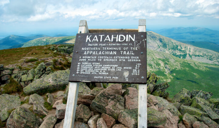
By now, you’ll have already built up your strength and stamina—and now’s the time when you’ll need it the most. The remaining 3 states are the hardest part of the entire Appalachian Trail with steep and rocky climbs up to 5,000-6,000 ft (1,524-1,829 m) high. Daily logistics and planning are also a must, due to no campsites at the Appalachian balds. You should finish up the hike by October 15 at the latest, when Baxter State Park—the end point of the thru-hike—closes the mountain down for hikers.
Vermont comes to the rescue if you’re sick of rocky terrain—there’s a reason why it’s called The Green Mountain State! Don’t let its dense forests and rolling pastures fool you, the trail is still challenging with vertical ascents up to 4,000 ft (1,219 m). Savor the verdant Vermont while you can, as the next state’s terrain is not as forgiving.
Distance: 150.8 miles (242.7 km)New Hampshire’s portion of the AT offers more miles above the treeline than any other state. It’s nearly all within the White Mountain National Forest, and you can expect incredibly steep terrain. Mind your step, especially if there’s bad weather, and be prepared for a very tiring part of the AT. Still, New Hampshire will remain an unforgettable section with epic views that make the struggle worth it.
Distance: 160.9 miles (258.9 km)Maine—the last part of the thru-hike. You made it! Maine is AT’s most challenging, rugged, and wild state, featuring wildlife and landscapes that are rare to see anywhere else on the trail, such as moose and sparkling lakes. You’ll encounter lots of slippery slopes, alpine bogs, and unbridged crossings. This is where you’ll pass the toughest mile, Mahoosuc Notch field filled with massive boulders, before you reach the infamous, final 100 miles of wilderness—a middle-of-nowhere section taking you to Baxter State Park and the final, most difficult ascent on Mt. Katahdin! The northern terminus is a place where thru-hikers take in the views and appreciate what they’ve just achieved.
Distance: 282 miles (453.8 km)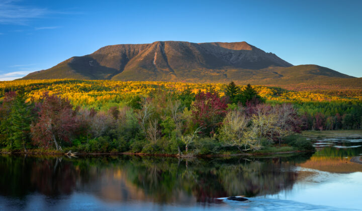
-
Congratulations on completing the iconic Appalachian Trail! Once you’re ready to leave the epic Mt. Katahdin, and finally go back to civilization for more than a day, you’ll picked up from Baxter State Park and transferred to Millinocket in Maine, a 45-minute drive. Meet your group of thru-hikers and have a celebratory dinner. After spending the night in Millinocket, your tour organizer can transfer you to the nearest bus station. Airport transfers can be arrange at an additional cost.
-
-
-
Included:
-
- Logistics planning
- 10-day orientation package (more on that in the “What’s included in the 10-day orientation?” section)
- Support vehicle (for storing extra gear, food, clothes, and supplies) — you’ll meet the support vehicle every 1-3 days
- Transportation to town for resupplies & doing laundry
- Occasional snacks and drink at the support vehicle
- Celebratory dinner on the last day
- Drop-off from the trail’s ending to Millinocket or nearest bus station
Not included:
-
- Flights to Atlanta at the beginning of the thru-hike and back home at the end of the thru-hike
- Shuttles to airports (unless you’re doing the 10-day pre-trip orientation, then you’ll get picked up from Atlanta Airport)
- Food during the thru-hike
- Lodging during the thru-hike
- Travel and medical insurance — mandatory
-
-
The 10-day pre-trip orientation is a fantastic way to prepare for your thru-hike. An experienced thru-hiker will give you insight into how to do resupplies, shuttles, hitchhiking, hostels, and all the ins-and-outs of the logistics and planning. You will also gain experience using gear and equipment out on the trail.
Hikers who choose to do the thru-hike, be it the whole way through or just a month-long section, have this 10-day orientation already included in the price.
Included:
-
- 10-day orientation package (3 days of orientation + 7 days of hiking)
- Lodging during the 3-day orientation (hotels or a bunk at a hostel)
- Lodging on the last day of hiking before you continue on your own (included for thru-hikers that are continuing on their own only)
- Food during the 3-day orientation
- Food on the last day of hiking before you continue on your own (included for thru-hikers that are continuing on their own only)
- Shuttles
- Pick-up in Atlanta at the airport or bus station
- Shuttle to Amicalola Falls SP and Springer Mountain
Not included:
-
- Flights to Atlanta
- Lodging once on the trail
- Food once on the trail
- Shuttle back to the airport (in case you’re only doing this 10-day orientation and not continuing with the thru-hike)
- Travel and medical insurance
-
-
After much research, you’ve made up your mind and decided to thru-hike the Appalachian Trail, but what now? There are many decisions and preparations ahead—logistics, gear, resupplies, just to name a few—but you don’t know where to get started? The whole trail measures 2,190 miles (3,524 km) in length, so carrying all your belongings, camping gear, and food every single day for 5 months is no walk in a park.
So, imagine this: you’re carrying a light backpack, doing longer mile days, not stressing about the food and resupplies, all the while getting the classic thru-hike experience of pitching a tent in the woods every night.
This is where we come in! Apart from a 10-day, pre-trip orientation to ensure everyone’s comfortable hiking on their own, a support vehicle will follow you all the way through. You’ll hike at your own pace and meet your support vehicle every 1-3 days. Here you’ll have lots of space for your extra food, gear, clothing, and toiletries.
About once a week, you’ll be transferred to a near-by town where you can resupply and do laundry. This way, you don’t have to hitchhike or pay for expensive shuttles into town.
This is a fantastic trip for solo travelers, as the support vehicle also serves as security—each hiker needs to check in every time they reach the vehicle or a crew member will hike back until they find them. Apart from the support vehicle serving as storage and security, you can also take showers, clean up, or take a break if you have a slight injury.
It’s also worth noting that if there’s ever been the time for a supported thru-hike, 2025 is the year. Due to severe flooding, many of the southern trail towns were decimated, and hikers will have to find their way to get further away from the trail for resupplies—having a support team on your side means that you’ll get transferred to potentially more distant towns for resupplies and lodging.
-
What we’re offering is a supported thru-hike, and you can read more about it above.
However, it’s also possible to slackpack (basically day hikes) most of the A.T., but there will be extra costs. This covers extra fuel costs, maintenance costs, and everyday shuttles in the morning and the afternoon. Apart from that, you will have to pay for lodging and food while in town. Another thing to keep in mind if you decide to slackpack is that you must be willing to pay for the driver’s lodging for the night if there is nowhere else for them to sleep.
Slackpacking the A.T. is doable, but expensive. Hikers must understand the costs involved for this type of hiking—if you want to slackpack for more than 50% of each month, the price is $1,500 per person, per month, plus all the lodging and food costs while you’re in town.
-
This supported thru-hike will roughly take 5-6 months, during which time you’ll get stronger and fitter. However, you still need to be prepared for such a demanding experience of thru-hiking the Appalachian Trail. Even if you’re doing a month or two, great fitness is still a must.
No experience is universal—among many other things, your age, health, and current fitness level determine how ready you are for the hike. Going on this supported A.T. thru-hike has lots of benefits that will put less strain on your body and shorten your time on the trail. Apart from carrying a significantly lighter backpack, you’ll also meet your support vehicle to resupply and have frequent access to amenities.
There’s no shortage of books, guides, and diaries about the AT, so it’s best to go through some of them and find out just how much preparation you will need—the internet is your friend here. Check out how to prepare for the thru-hike of the Appalachian Trail and don’t miss out on these 15 tips for a thru-hiking first timer!
-
The camaraderie, trail magic, and the sheer number of hikers all make the trail accessible for just about anyone. People of all ages, from 5 to 86 have hiked the trail.
The hiking community varies in age, occupation, experience and fitness levels. While there are hikers in their 20s and 30s, there are even more hikers in their 50s or even 60s. The only criteria you have to fit is to have a desire to be outdoors!
Everybody over the age of 16 is welcome on this hiking adventure.
-
This is a fantastic adventure for solo travelers! Actually, a great majority of thru-hikers hike (or at least start hiking) alone.
The support vehicle also serves as security—each hiker needs to check in every time they reach the vehicle or a crew member will hike back until they find them.
You will also meet many hikers who share the same values and goals, and likely make friends for life!
-
There are many gear lists for thru-hiking the AT available online. However, there may be some items here that you consider unnecessary or some that didn’t make the list, but you’d still like to take them. Feel free to contact us should you have any questions or dilemmas regarding the equipment, we’re happy to help!
Obligatory equipment
-
- Backpack large enough to carry all the items you need for the day, or a couple of days until you meet the support vehicle (55-65L bag)
- Rain cover for backpack
- Hiking poles
- Tent (should be under 3 lbs)
- Sleeping bag (try to stay under 2 lbs, keep in mind that temperatures can drop to 0°F during the night, Therm-a-Rest recommended)
- Sleeping pad (under 2 lbs, Therm-a-Rest recommended)
- Waterproof compression sack for the sleeping bag (Sea to Summit eVent recommended)
- Water filter (Katadyn Vario or Katadyn BeFree recommended)
- Hydration bladder (2L capacity)
- Camp stove (PocketRocket or Jetboil recommended)
- Cooking pot (titanium recommended)
- Fuel canister (5-7 oz propane / butane blend)
Clothing
-
- Baselayer clothing, fleece layer, insulating jacket
- Waterproof rain jacket (and pants if you prefer it)
- Hiking (wicking) clothing
- Hiking socks and underwear
- Lightweight hiking boots or shoes
- Camp shoes (flip flops, Tevas, Crocs — something to walk around camp)
- Gaiters
- Gloves
- Bandana
- Sunhat or some sort of head cover
Personal gear
-
- Physical guidebook (in case your phone fails you)
- Drawstring sack to place your food in (needs to have some sort of tie at the top so it can be hung by a rope)
- Compression sack for your clothes
- Ziploc bags (quart & gallon) for food and valuables
- Camp food (resupplies every couple of days)
- Headlamp
- Ear plugs
- Lighter
- Cooking gear (utensils, spices, cup, small knife)
- Sunglasses
- Camera — optional but recommended
- Charger, cable, and a power bank
- Pepper spray — optional
Toiletries and first aid supplies
-
- Sunscreen and SPF lip balm
- Personal medication
- Toilet paper
- Wet wipes
- First aid kit (ibuprofen, bandaids, blister prevention…)
- Biodegradable soap and deodorant
- Toothbrush and toothpaste
- Hair ties, comb
- Bug spray
-
-
Group size
The maximum group size for this supported AT thru-hike is 10. It takes a minimum of 5 people for this tour to operate.
Pricing & guarantee to run for…
- The month-by-month supported thru hike (choice to hike a month, two, or however many you wish)
-
- A 30% deposit is required upon booking.
- The rest of the balance is due 90 days prior to departure.
- There are no refunds after January 1, 2025, so as to make sure hikers are absolutely certain about doing the thru hike.
- The supported thru-hike (lasting 5 to 6 months, price remains the same)
- A 30% deposit is required upon booking.
- The rest of the balance is due 90 days prior to departure.
- There are no refunds after January 1, 2025, so as to make sure hikers are absolutely certain about doing the thru hike.
- Since this is a big 5 to 6-month undertaking, we will collect entries for the trip for up to 20 people. First 10 people that confirm their booking by paying a $5,000 deposit will get to go, and the other 10 will join a waitlist in case anyone has to cancel their participation.
-
You’re doing a northbound thru-hike of the A.T., meaning that your adventure starts in Georgia. As you have a 10-day orientation prior to getting on the trail (included in the price of the tour if you’re doing the full thru-hike or the month-by-month thru-hike), most people fly into Hartsfield-Jackson Atlanta International Airport (ATL). You will be picked up at the airport around 1pm on Day 1 of the orientation.
A.T. ends in Baxter State Park, Maine. You will be picked up and transferred to Millinocket or the nearest bus station. Shuttle to the nearest airport is also available, but at an additional fee.
-
Medical and travel protection is mandatory. To make your booking and traveling experience as carefree as possible, simply choose Redpoint—the official 57hours insurance partner!
Redpoint tailors their protection packages for adventure travel, offering a comprehensive travel program, even in remote locations. Trip cancellation, natural disasters, pandemic coverage, medical evacuation, primary medical expenses—regardless of the travel interruption that may happen, Redpoint will have you covered.
Once your booking is confirmed and your trip is paid in full, you will be offered to purchase Redpoint’s protection. If you need any help or require more information, let us know and we will be happy to help!
-
Have more questions?
Read our FAQ