-
Thru-hiking the Appalachian Trail is on top of every serious hiker’s list. Not a lot of them dare to undertake it and even fewer people thru-hike it all—less than a 1,000 people manage to finish the AT yearly, and in 2024, you’re bound to be one of them. With our all-inclusive slackpack-supported thru-hike, the only thing you have to worry about is putting one foot in front of the other—from Georgia to Maine—and enjoy the journey at your own pace. You’ll be carrying a very light backpack with essentials for the day, allowing you to cover more distance. When evening comes, your guides will pick you up and transport you to the nearest lodging, and in the morning, they’ll take you back to the trail. Food of your own choice is also included in this supported thru-hike! Minimize all the risks hikers usually struggle on the AT with and maximize your fun and chances of success!
-
The hike will start in late-April or early May. This is a rough estimate of what a 5-month thru-hike of the Appalachian Trail northbound will look like. Each hiker can hike at their own pace. Learn how to prepare for thru-hiking the Appalachian Trail and check out these 15 AT hiking tips for first-timers by a three-time AT thru hiker.
There might be a few times that hikers will have to overnight on the trail due to lodging being too far. In that case, your guides will set up the camp near the trailhead and provide all the following equipment: camp stove, cooking pot, fuel canister, tent, sleeping bag and pad, and waterproof compression sack for the sleeping bag.
To learn more about what you can expect regarding the logistics of slackpacking the Appalachian Trail, scroll down and check out the FAQ.
.
-
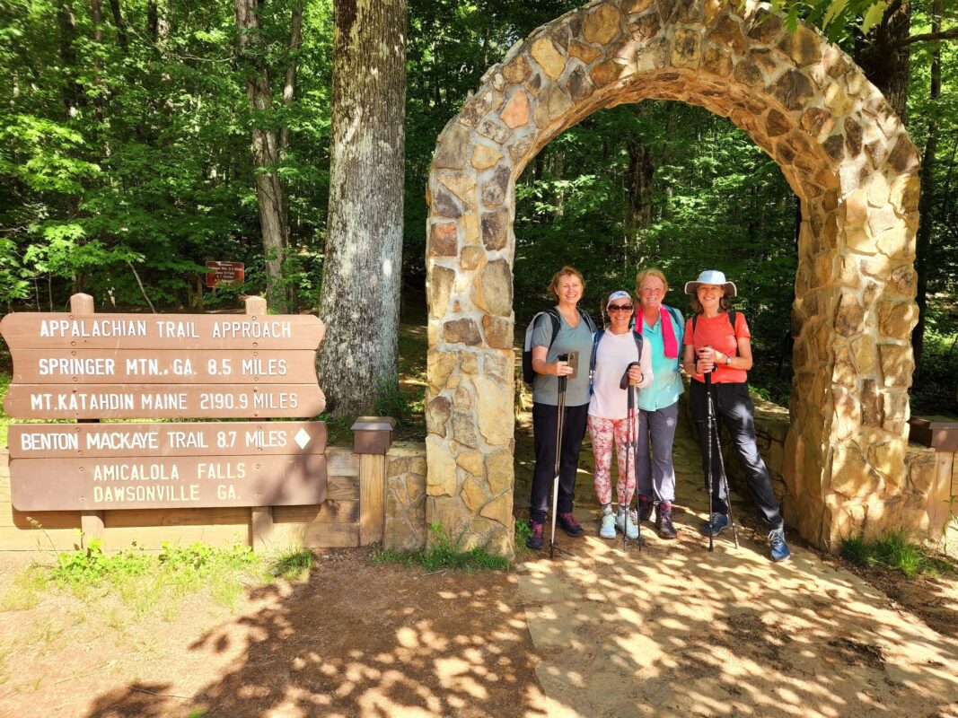
Prior to actually getting on the trail and starting your epic journey, you’ll have a 3-day orientation in Villa Rica, GA, to prepare. You’ll go over gear, clothing, food, and the itinerary with your guides and your fellow thru-hikers. Shuttle to Amicalola Falls State Park, where you will register for the thru-hike. Then you’ll get transferred to Springer Mountain, the southern terminus where your life-changing adventure begins.
Each evening, thru-hikers will be picked up and transported to the nearest lodging facility, campground, or campsite area—whichever makes the most sense logistically and timewise. Note that there will be a few times that hikers will have to overnight on the trail because of no access points and long mileage days between roads. In that case, your guides will provide and set up tents and other needed gear.
-
You’ll spend your first month passing through Georgia and North Carolina.
Georgia is a fantastic place to get into the mindset of thru-hiking—the trail is wide and smooth and the terrain is relatively easy compared to the rest of the trail. You’ll begin your journey in Springer Mountain and soon you’ll get used to day hikes through the wilderness.
Distance: 78.1 miles (125.7 km)North Carolina starts to give you an idea of (literal) ups and downs of the AT. Just south of the Smokies, you can expect long climbs and many scenic views. The NC portion of the trail continues along the border with Tennessee.
Distance: 96.4 miles (155.1 km)Keep in mind that the weather will be very cold with possible snow and ice at times. Average day temperatures could be anywhere between 20 and 50° F, while at night it could go down to 0° F.

-
Hike through your first trail town on the AT! These communities recognized as valuable places for thru-hikers, providing food, supplies, history, recreation, and much more. Once you’ve passed through the Smokies, the weather usually starts to warm up, and it could be time for a gear change.
Border of North Carolina & Tennessee runs along Great Smoky Mountains National Park (for which $25 permits are required), the most biologically diverse and the most visited NP in the States. Spectacular vistas are guaranteed, as you’ll frequently climb above 5,000 and 6,000 ft (1,524-1,829 m) and also pass through the highest point of the AT, the 6,625-foot (2,019-m) Clingmans Dome. You’ll reach your first trail town, Hot Springs.
Distance: 217.8 miles (350.5 km)Tennessee welcomes you with the 2nd trail town of the AT, Erwin. Other than that, highlights of the state might be high-elevation summits, dense forests, and Laurel Fork, a serene gorge featuring 40-foot waterfalls. Hopefully, you’ll hit your 3rd trail city, Damascus, Virginia, just in time for a hiker festival, where you can expect a parade, arts & crafts booths, gear booths, prize giveaways, food trucks, and more!
Distance: 74.7 miles (120.2 km)
-
Weather begins to warm up and hikers need to switch to summer gear. Average day temperatures are around 50 to 90° F during the day, while the night brings a bit cooler weather at around 40 to 60° F.
Virginia has more miles of the AT than any other state, accumulating nearly a quarter of the entire trail length, and it’s a place where you’ll spend at least a month. While Southern Virginia is a challenging section featuring long climbs along the Blue Ridge Parkway, Northern Virginia and Shenandoah National Park boast mellow sections on farmland and rolling hills. Exit the park around Front Royal, and you’ll soon enter West Virginia.
Distance: 541.7 miles (871.8 km) + 25.2 miles (40.6 km) along VA/WV border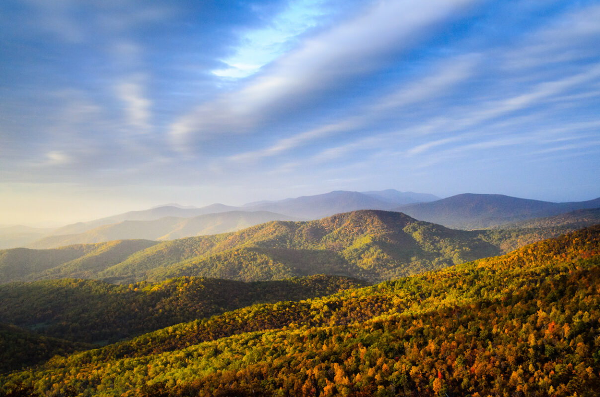
-
In July, the weather starts getting hot and humid. Be prepared for day temperatures going above 85° F. The terrain starts to get easier and flatter, but the trail itself becomes rockier.
West Virginia’s section of the Appalachian trail is by far the shortest, but still very important for thru-hikers as they pass through Harpers Ferry. Apart from being a site of notable Civil War battles, it’s also home to Appalachian Trail Conservancy’s headquarters and a symbolic AT midpoint.
Distance: 2.4 miles (3.9 km)Maryland is a fan favorite—it hosts some of AT’s gentlest and flattest terrain, you can hike it in just 2 days, and it’s close to the buzzing Washington, D.C. Consider Maryland the calm before the storm, as you have the rocky Pennsylvania next up.
Distance: 40.9 miles (65.8 km)Pennsylvania, also known as “Rocksylvania”, is where you get to show what you’re made of. While the north features rocky terrain that’ll test your feet, southern PA offers some of the smoothest terrain of the whole AT. Factor in historic landmarks and charming towns along the way as well as expansive views off the top of ridges, and you’ll find that you have to gird your loins for Pennsylvania’s rewards.
Distance: 229.8 miles (369.8 km)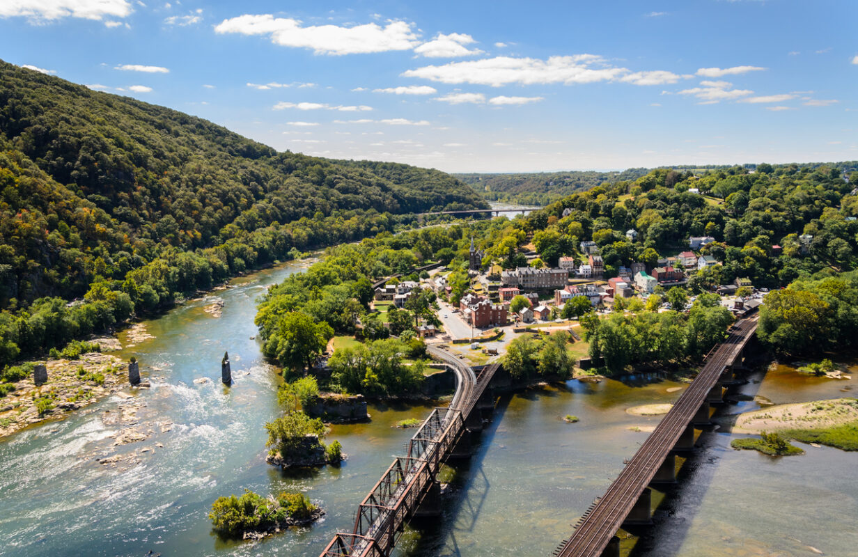
-
Longer days and flatter terrain during this month make hiking a bit easier, allowing many hikers to pick up the pace, with many covering 15-20 miles (24-32 km) a day. These states don’t have long stretches of the AT, so you’ll go through them in a matter of days to a week. The trail runs through populated areas, along roads, and through farmlands. Weather is still hot and water sources can be contaminated with farm pasture runoffs, so make sure you’re filtering your water.
New Jersey offers two great things: feeling of remoteness in the wilderness, but still being very close to major cities. Elevation changes are generally moderate, and you’ll go through a whole spectrum of great views. AT also passes through the Wallkill National Wildlife Reserve, where it’s likely you’ll meet the state bird—the eastern goldfinch.
Distance: 72.4 miles (116.5 km)New York has plenty to look forward to, but with its steep climbs and tough scrambles, it’s no walk in the park. Pass a Trailside Museum and Zoo in Bear Mountains (which is also the lowest elevation point on the entire AT), find numerous trailside delis in this state, and there’s even a chance to see the Manhattan skyline from a distance.
Distance: 93 miles (149.7 km)Connecticut, which is among the shortest sections of the AT, still features tough, rocky climbs—after which you’re rewarded with long miles of easy hiking and relaxing river walks. For most of the state, you’ll be hiking through the green tunnel, but every now and then, you’ll make your way out of the trees to witness spectacular panoramas.
Distance: 52 miles (83.7 km)Massachusetts boasts longer views and higher elevations—on a clear day, you can see up to 90 miles (145 km) in the distance. From river walks and fields of conifer woodlands to charming New England towns, this state has it all. Massachusetts is also home to Mt. Greylock, the mountain which served as an inspiration to Melville to write Moby Dick.
Distance: 90.2 miles (145.2 km)
-
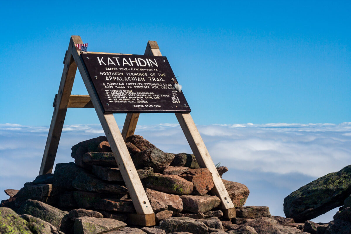
By now, you’ll have already built up your strength and stamina—and now’s the time when you’ll need it the most. The remaining 3 states are the hardest part of the entire Appalachian Trail with steep and rocky climbs up to 5,000-6,000 ft (1,524-1,829 m) high. Daily logistics and planning are also a must here, due to no campsites at the Appalachian balds. Hikers should finish up their hike by October 15 at the latest, when Baxter State Park—the end point of the thru-hike—closes the mountain down for hikers.
Vermont comes to the rescue if you’re sick of rocky terrain—there’s a reason why it’s called The Green Mountain State! Don’t let its dense forests and rolling pastures fool you, the trail is still challenging with vertical ascents up to 4,000 ft (1,219 m). Savor the verdant Vermont while you can, as the next state’s terrain is not as forgiving.
Distance: 150.8 miles (242.7 km)New Hampshire’s portion of the AT offers more miles above treeline than any other state. It’s nearly all within the White Mountain National Forest, and you can expect incredibly steep terrain. Mind your step here, especially if there’s bad weather, and be prepared for a very tiring part of the AT. Still, New Hampshire will remain an unforgettable section with epic views that make the struggle worth it.
Distance: 160.9 miles (258.9 km)Maine—the last part of the thru-hike. You made it! Maine is AT’s most challenging, rugged, and wild state, featuring wildlife and landscapes that are rare to see anywhere else on the trail, such as moose and sparkling lakes. You’ll encounter lots of slippery slopes, alpine bogs, and unbridged crossings. This is where you’ll pass the toughest mile, Mahoosuc Notch field filled with massive boulders, before you reach the infamous, final 100 miles of wilderness—a middle-of-nowhere section taking you to Baxter State Park and the final, most difficult ascent on Mt. Katahdin! The northern terminus is a place where thru-hikers take in and appreciate what they’ve just achieved.
Distance: 282 miles (453.8 km)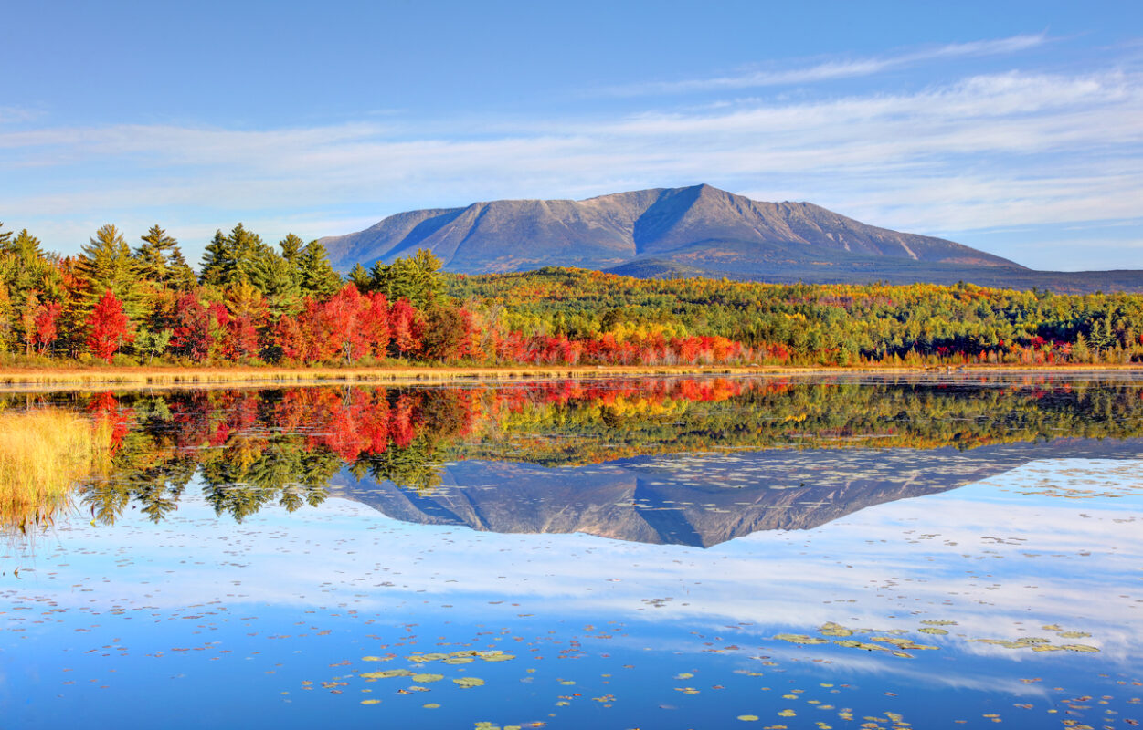
-
Congratulations on completing the iconic Appalachian Trail! Once you’re ready to leave the epic Mt. Katahdin, and finally go back to civilization for more than a day, your guides will pick you up from Baxter State Park and transfer you to Millinocket in Maine, a 45-minute drive. Meet your group of thru-hikers and have a celebratory dinner. After spending the night in Millinocket, your guides can transfer you to the nearest bus station. If you need to reach an airport, your guides can arrange that at an additional cost.
-