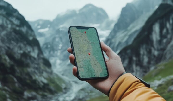
We shift to digital tools, starting with a deep dive into CalTopo: building routes, layering map types, caching offline data, and sharing trip plans with your group. After classroom instruction, we head into the field for scenario-based exercises that integrate both analog and digital systems. We practice pulling up saved routes offline, track our GPS position in real time, and cover practical strategies for battery management in remote and winter conditions.
-
A standalone 1-day course focused on digital land navigation tools. We cover CalTopo from the ground up: route planning, map layering, offline GPS, and trip sharing before heading into the field for scenario-based exercises that put it all into practice. We also cover battery management strategies for remote and winter conditions. Some familiarity with map reading is helpful but not required. Groups are capped at 6 participants. Module 1 can be taken the day before if you want the full analog foundation first.
-
-
-
Included:
-
- Experienced, local backcountry navigation instructor with extensive knowledge of the area
- Printed topographic map
- Certificate of completion (2-day course only)
Not included:
-
- Food, snacks, and water
- Baseplate compass (Suunto A-10 or equivalent) — required, not provided
- Smartphone with CalTopo downloaded and offline maps cached
- Transportation to and from the meeting point
- Anything not mentioned in the “Included” section above
- Insurance — recommended, available to add at checkout
- Guide gratuities — optional
-
-
This land navigation course involves some light hiking in Colorado terrain to practice navigation skills in the field, but it is not physically demanding. Basic fitness is required.
If you are comfortable walking on uneven terrain for a few hours, you are good to go. No prior navigation or backcountry experience is required. The course is designed to work for complete beginners.
-
If you want the full picture, take both modules back-to-back over the weekend. The two days are designed to work together, analog one day and digital the next, and you’ll walk away with a certificate of completion and a skill set that covers every situation the backcountry can throw at you.
If you’re starting from scratch or want to nail the fundamentals first, Module 1 is your entry point. We cover topographic maps, compass work, and real-world route-finding decisions entirely without relying on your phone.
If you’re already comfortable reading terrain and want to level up with digital tools, Module 2 focuses on CalTopo, offline GPS, and integrated field navigation.
-
Here’s a list of the equipment you need to bring:
-
- Baseplate compass (Suunto A-10 or equivalent) — required, not provided
- Smartphone with CalTopo downloaded and offline maps cached before the course
- Daypack with the 10 essentials: navigation tools, sun protection, extra insulation, headlamp, first aid kit, fire starter, repair kit or multi-tool, food, water, and emergency shelter
- Layered clothing appropriate for the season
- Sturdy hiking footwear
- Water bottle or hydration system (at least 1L)
- Lunch and snacks for the day
Dress comfortably and for the weather in clothes you can move in. We suggest bringing clothing appropriate for the season. Layers are best and don’t wear jeans.
Got everything you need? Grab your gear through Active Junky and earn cash back on top outdoor brands — plus a $10 bonus on your first $25+ purchase. Shop now at Active Junky!
-
-
Group sizes and pricing
-
- For this land navigation course in Colorado, the usual client-to-guide ratio is 6:1.
- It takes a minimum of 3 people for this tour to operate. The maximum group size is set at 6 participants.
A land navigation course in Colorado can be arranged for larger groups. Contact us to make arrangements.
Min. age requirements
-
- If you are older than 18, you’re good to go.
- Minors older than 12 may be permitted to join the land navigation course in Colorado on a case-by-case basis, but must be in the presence of a parent or legal guardian.
If your group has participants under the age of 18, contact us prior to booking to make arrangements.
-
-
The starting point of your land navigation course in Colorado is 204 Ryan Gulch Road, Silverthorne, CO 80498. The nearest major airport is Denver International Airport (DEN). Most participants drive from the Denver metro area via I-70, approximately a 1.5-hour drive. For those coming from western Colorado, Eagle County Regional Airport (EGE) is roughly 45 minutes away.
You will meet your guide at 204 Ryan Gulch Road, Silverthorne, CO 80498, either on the first or the second day, depending on the module you’ve chosen. Exact meeting time will be confirmed upon booking.
-
We highly recommend that you cover all your bases with insurance. To make your booking and traveling experience as carefree as possible, you’ll be offered to simply insure your trip with Redpoint at checkout.
Redpoint—the official 57hours insurance partner—tailors protection packages for adventure travel, offering a comprehensive travel program, even in remote locations! Trip cancellation, natural disasters, pandemic coverage, medical evacuation, primary medical expenses—regardless of the travel interruption that may happen, Redpoint will have you covered.
-
Have more questions?
Read our FAQ